
Rämistrasse
| Rämistrasse | |
|---|---|
|
|
|
 |
|
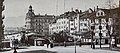
| Lower Rämistrasse, view to the west to Bellevue | |
| Basic data | |
| place | Zurich |
| Quarter | Old town , Hottingen , Fluntern , Oberstrass |
| Created | 1836 |
| Name received | 1865 |
| Connecting roads | Quaibrücke , Universitätsstrasse |
| Cross streets | Utoquai , Limmatquai , Oberdorfstrasse , Hirschengraben , Zeltweg , Hottingerstrasse , Zürichbergstrasse , Gloriastrasse , Schmelzbergstrasse , Tannenstrasse |
| Places | Bellevue , potato market , Heimplatz (peacocks) |
| Buildings | Art house , theater , canton school Rämibühl , university , ETH , university hospital |
| Tram | Bellevue, Kunsthaus, Cantonal School, ETH / University Hospital |
| use | |
| User groups | Motorists, trams |
| Technical specifications | |
| Street length | 1311 m |
The Rämistrasse is a 1311 meter long street on the southeast edge of the old town of Zurich . The road belongs to the main axis from Bellevueplatz towards Winterthur .
course

The Rämistrasse leads slightly uphill from Lake Zurich to the university district in the lower area of the Zürichberg . For the first 500 meters it connects Bellevue and Heimplatz , usually called Pfauen . In the upper area of this section, after the junction of the Hirschengraben , it runs in a breakthrough in the Hohe Promenade .
From Heimplatz, the street follows the district boundary between the old town and Hottingen to Zürichbergstrasse. In this area it makes an arc to the north, besides a slight curve in the lower part the only change of direction in the street. As a result, it forms the border between the old town and Fluntern .
After the intersection with Tannenstrasse, the street axis changes its name and is henceforth called Universitätsstrasse .
history
The road was laid out in 1836 after the demolition of the Rämibulwerk of the city fortifications . The name of the bulwark comes from a field name that can be traced back to a landowner Remi ( Remigius ) . The bastion extended roughly from Heimplatz to the universities, its center was at the old canton school . The name Rämistrasse was probably first used in 1865.
As an extension of the Oberen Strasse , which connected Zurich with Winterthur, and using the space gained by the removal of the city fortifications, the new Rämistrasse led down less steeply from the heights of the Zürichberg to the city. Oberstrass, Fluntern and Hottingen were still independent communities at that time.
Below the Rämibollwerk, next to the Wolfbach, the Hottinger gate led through the city fortifications. The moraine hill of the Hohe Promenade rose between Wolfbach and the lake . There was already a cut between this and the Winkelwiese: the moat of the second city fortifications (Oberer Hirschengraben), which had been expanded into a road towards the lake from 1784. In the lower course, this route was continued at the Oberdorftor in Schmidtengasse . The piercing through the promenade hill between Hirschengraben and Wolfbach took place after 1830. The square between Oberdorfstrasse and Waldmannstrasse was the former potato market. The name is still used today, but is not an official street name for the city.
The Rämistrasse between Wolfbach and Lake Zurich made use of the new cut and then led over the last part of the Oberer Hirschengraben, the Kartolffelmarkt and the Schmidtengasse.
After the bastions had been razed, the bank area on Lake Zurich also developed, first a harbor was created, then the Salzhausplatz and the Bellevue Hotel, later the Bellevue Platz, which after the construction of the Quaibrücke in 1873 became one of the most important traffic junctions in the City developed. The park at Wolfbach with a pool was also given up for an urban square and converted into a square at the end of the 1880s, today's Heimplatz. Towards the end of the 19th century, more and more high urban houses were built along the lower part of the street and around Heimplatz.
Around 1900, looking west towards the Bellevue. Only the scaffolding poles stand from the Denzler houses on Torgasse.

Comparable situation in 2013

Rämistrasse 1902, view of Heimplatz

same place 2009

Old canton school on Rämistrasse (right) with Wolfbachbassin below the gymnasium


Development

There are important public buildings along Rämistrasse. A formative and powerful building was the old canton school built in 1842 in the curve above the Wolfbach with parks. After the cantonal high school for adults was housed there for a long time , the building now serves the university . At the same time, other public buildings were built on the street.
The university hospital at the upper end of Rämistrasse was also opened in 1842 . Opposite him, the construction of a building for the Federal Institute of Technology began in 1858 and opened in 1864. Initially, the university was also located there, and in 1914 it was able to open its own main building, adjoining it south on Rämistrasse. Other buildings in the university quarter along Rämistrasse are a university building from 1908, which houses the library of the law faculty in its inner courtyard , and the archaeological collection .
The Kunsthaus and the Schauspielhaus are located in the peacock complex at Heimplatz . Above Heimplatz is the Rämibühl Cantonal School on the right-hand side behind some town villas .
traffic

The Rämistrasse is an important axis in Zurich, which leads the traffic to the south and east around the old town. Starting at the Bellevue traffic junction, it also serves as an axis from the center to the eastern districts of the city. The street is part of Hauptstrasse 17 , which connects the areas in the north of the city to the right bank of Lake Zurich . It is also part of the Rämi-, Universitäts- and Winterthurerstrasse axis that leads to Winterthur. In their extension in the south-west, the Quaibrücke and General-Guisan-Quai open up the south-west of the city.
In Raemistrasse runs over the entire length of the tram lines 9. The line 5 leads from Bellevue to the junction in the Gloriastrasse, the line 6 from the Tannenstrasse also to the junction in the Gloriastrasse.
Web links
Individual evidence
- ↑ a b c The Rämistrasse. In: Gang dur Alt-Züri. Retrieved December 29, 2019 .
- ↑ City map. In: Geoportal City of Zurich. Retrieved on December 30, 2019 (explanations on Rämistrasse).
- ^ Mathias Dürst: The Hirschengraben. In: Gang dur Alt-Züri. Accessed December 30, 2019 .
- ↑ Tina Fassbind: Zurich pretties up the potato market . In: Tages-Anzeiger . November 14, 2017, ISSN 1422-9994 ( tagesanzeiger.ch [accessed December 29, 2019]).
- ^ Matthias Dürst: The Bellevueplatz (also called the Bellevue). In: Gang dur Alt-Züri. Accessed December 30, 2019 .