
City fortifications of Zurich

The city wall and city fortifications of Zurich were built in several steps between the 13th and 18th centuries and were completely removed in the 19th century, apart from a few small remains.
See also: List of technical terms in fortress construction
The first city fortification
The first city fortifications from the 11th / 12th centuries. Century is only partially explored. It ran to the left of the Limmat from the Lindenhof , which was still fortified by a palace, along Kuttelgasse to today's Bahnhofstrasse and turned off at Kappelergasse to the bank of Lake Zurich, which at that time was still further west . To the right of the Limmat, presumably along Kirchgasse to Hirschengraben , then along Seilergraben to Gräbligasse, where it ran down to Limmat.
The oldest fortification of the Lindenhof goes back to Roman times. Since the 2nd century BC A Roman military post seems to have existed in Turicum . In the late Roman times a fort with ten towers was built on the hill. The fort existed until the early Middle Ages when a Carolingian and later an Ottonian palace was built on its foundation walls . The Palatinate was first mentioned in a document in 1054. Almost nothing is known or archaeologically documented about the Carolingian Palatinate. The second, Ottonian Palatinate from 10/11. Century is better documented. It was one of the centers of the Duchy of Swabia and had a palace building and a chapel. In the 11th / 12th In the 18th century, the complex was converted into a castle, which was last mentioned in 1172. Whether the complex was destroyed according to plan after the Zähringer died out in 1218 or whether it gradually disappeared as a quarry cannot be proven for certain.
The second city fortification

The second city fortification from the 13th century is well documented by several plans and contemporary illustrations, such as the Murer plan. It followed the Limmat to the left from Bahnhofquai (at Mühlesteg ) from Werdmühlestrasse via Werdmühleplatz to the confluence of Rennweg with Bahnhofstrasse, then ran along Bahnhofstrasse to Börsenstrasse, which formerly formed the bank to Lake Zurich. On the right side of the Limmat, the fortifications began at today's Hotel Bellevue and led along Torgasse up the hill above Rämistrasse to Hirschengraben via Seilergraben to Central.
In the 16th century, bulwarks were occasionally built to reinforce or modernize the system of the second city fortifications. The best-known and largest of these was the Rennweg bulwark, which is said to have been constructed on the model of the Milan castle . From 1620, the city council had plans for a new fortification made, but up until 1638 only a few reinforcements were made to the old structures by adding so-called outer works to reinforce the old towers.
The total length of the walls was approx. 2400 meters. The walls were eleven meters high and up to 2.7 meters thick. They were reinforced by 16 towers, five of which served as city gates. Towards the lake, the city was protected by a double row of palisades , the so-called "Schwirren". A special gate in the water, the Grendeltor, served as a passage . Sometimes houses or rows of houses were built into the city wall, for example at the Oetenbachkloster, at the Kappelerhof or in the Torgasse. The walled area was about 38 hectares and included the settlement area and the six monasteries as well as vineyards and gardens as well as workshops and the port. The section of the wall to the left of the Limmat was reinforced by moats, the frogs' moat and the Sihl moat. Because this was not possible on the right side of the Limmat, a deep ditch and a smaller wall were dug below the wall, followed by a second, less deep ditch. At the Wollishoferturm and the Wolfsturm, water courses were led through the walls.
Towers and gates of the city wall to the right of the Limmat

(see colored Murer map, Arabic numerals 1–10)


- Grendeltor , built in the middle of the 15th century, served as a passage through the palisade structure made up of "buzzing", called "Grendel". Guard's apartment in frame work (so-called “Grendelhütte”) above the archway made of ashlars, access via a staircase leaning against the curtain wall, demolished in 1836.
- Langenörlisturm or Fischers- or Salzturm ( 2 ), first mentioned in 1444, later referred to as "Salzturm", formed the lower end of the Torgasse and was first attached to the Lochmannsche Haus and then to the Haus zum Egli, demolished in 1889.
- Bollwerk am Dorf ( 3 ), built in 1525 to reinforce the southern fortifications, next to it the so-called “coal port”, 1671 converted into a salt store, demolished in 1881.
- Oberdorftor ( 4 ), first mentioned in 1266, with drawbridge, passage towards Rapperswil, inside originally open, later bricked up, with clock after 1580, broken off in 1812.
- Geissturm ( 5 ) or Powder Tower , served as a powder store, as it was the tower furthest away from the urban settlement, explosion in 1652 by lightning, a pavilion was built instead of the tower.
- Lindentor or Junkerntor ( 6 ), first mentioned in 1149, "Lindentor" after the linden trees planted on the wall, passage in the direction of Hottingen , original tower open on the inside, broken off in 1580 and replaced by a bulwark with two rondelles, "Junkerntor" probably because of the nearby Residences of wealthy families, demolished in 1813. The permanent house to the Engel or St. Michaels Pfrundhaus was added, demolished in 1580.
- Schrättelisturm or Wolfsturm ( 7 ), since 1576 "Wolfsturm" (after the Wolfsbach, which was led into the city by the tower), served a. a. for storage of ammunition and powder, canceled in 1784.
- Neumarkt - or Kronentor ( 8 ), first mentioned in 1257, passage towards Winterthur («Obere Strasse»), 1340 «Neumarktsturm», 1404 «Neumarktstor», after 1637 «Kronentor» (after the inn «zur Krone»), with drawbridge, 1629 Reinforcement of the gate tower and gatehouse with outer works, demolished with the adjoining house "zum Kronentor" in 1827.
- New tower or Ketzerturm ( 9 ), rarely also Gräblisturm (after Gräbligasse), first mentioned in 1314, "New Tower" since 1526, "Ketzerturm" from 1588, was used to store military equipment and as a prison (including for the Anabaptists ), Since 1543 it has been fitted with the old St. Peter's tower clock, 1631 reinforced by a bulwark, demolished in 1878.
- Niederdorftor ( 10 ), first mentioned in 1270, with drawbridge, passage in the direction of Schaffhausen and Eglisau («Untere Strasse»), 1629–33 reinforcement by a Vorwerk, since 1675 with clock, demolished in 1824.
Towers and gates of the city wall to the left of the Limmat
(see colored Murer map Arabic numerals 11–23)
- Oetenbachbollwerk ( 11 ), built in 1532 instead of a wooden fortification in the garden of the former Oetenbach monastery , first an open roundabout, 1642 provided with a roof, 1764 converted into an economic building for the newly built orphanage, demolished in 1903. Ulrich von Regensberg's tombstone was found during demolition the back of which had been used as a window ledge.
- Oetenbacherturm and Oetenbacher Amtshaus ( 12 ), the former built around 1292 as a step tower, expanded and raised in 1545, built with two wide arches over the water supported by buttresses, connected to the monastery with a three-story covered bridge, in 1772 partially demolished completely in 1813.
- Rennwegtor or Rennwegbollwerk ( 13 ), first mentioned in 1355, part of the city expansion to the west, replaced the Kecinstürlin as the most important passage to the west to the bridge at St. Jakob an der Sihl (road to Baden), demolished and replaced by a bulwark in 1521, two roundabouts with gate and guard house, both roundels later covered with a roof, 1789 construction of a stone bridge over the frogs' pit, demolished in 1865.
- Neuturm , Kuttelturm or kauffelerturm ( 14 ), mentioned for the first time in 1224, at the lower end of Kuttelgasse (originally "Neue Gasse", as it emerged from the first town fortifications filled in around 1300), demolished in 1816.
- Ketzistürli and tower at Ketzistürli or Augustinian bulwark ( 15 ), first mentioned in 1224, originally the main passage to the west to the bridge at St. Jakob an der Sihl (road to Baden), replaced with a bulwark in 1575, a rondelle with a gate, later covered , canceled 1812/13.
- Augustinerturm ( 16 ), first mentioned in 1315, demolished in 1811.
- Hartmannsturm or Löwenturm ( 17 ), first mentioned in 1444, broken off in 1816.
- Wollishoferturm ( 18 ) and Wollishofertürchen, little door mentioned for the first time in 1293, tower in 1444, the passage into the tower was relocated in 1576, from 1650 Katzentor, since 1630 with clock, 1788 construction of a stone bridge over the Fröschengraben, demolished in 1815.
- Abbess Tower or Werkhofturm ( 19 ), first mentioned in 1444, demolished in 1829.
- Kappelerhof ( 20 ), first mentioned in 1270, administrative building of the Kappel monastery , demolished in 1878.
- Kratzturm ( 21 ), first mentioned in 1293, since 1444 "Kratzturm" (after the quarter " Kratz "), reinforced in 1621 by the bulwark "am Spitz", 1803 extension of a social building, demolished in 1877 (extension of Bahnhofstrasse).
- Ravelin im Kratz ( 22 ), built in 1541, a roundabout without a roof, 1583–1586 extension of the municipal Bauhaus, elevation and roofing of the roundabout, demolished in 1886.
- Wellenberg ( 23 ), served as a prison, 1778 extension of a front building on the north side with two interrogation rooms, partly burned out in 1799, demolished in 1837.
Aristocratic towers on both sides of the Limmat
(see colored Murer map, Roman numerals I-IX)

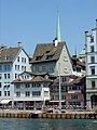
- Mülner - or Schwerttürme ( I ), from the 13th century, residence of the Mülner knight family, former hotel and today's house at the sword includes two former towers on the west (front sword tower) and on the north side (rear sword tower) of the building complex, towers as Part of the house has been preserved to this day.
- Red Tower ( II ), from the 13th century, property of the Counts of Rapperswil, 1486 municipal magazine for fire extinguishers, later converted into a coffee house, as a café littéraire meeting place for radicals and liberals, demolished in 1938.
- Hottingerturm ( III ), from the middle of the 12th century, property of the Counts of Kyburg, fief of the noble von Hottingen, later converted into a municipal department store and salt store, demolished in 1856.
- Manesse , Schwenden or Blarerturm ( IV ), from the 13th century, name of the Manesse family, later by the Schwend and Blarer families, demolished after 1834. The rear building of the Manesseturm at Napfgasse 4 is still today as a listed building " Schober Confectionery ".
- Brunnenturm or Lamparterturm ( V ), from the 13th century, name of Lombard merchants, then named after the fountain that was built in front of the tower in 1568, repeatedly renovated and rebuilt, still preserved as a tower today.
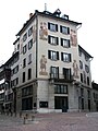
- Grimmenturm ( VI ), first mentioned in 1324, first named after the Bilgeri family, then after Johannes Bilgeri the Elder. J., called “Grimme”, awarded to the Beguines in 1350, later the official residence of the city chairman “common monasteries”, since the 16th century with a clock, remodeling and renovation in the 19th century, preserved as a tower to this day, is considered to be on best preserved aristocratic tower in Zurich.
- Bilgeriturm ( VII ), from the 13th century, name of the Bilgeri family, included in the new building of the guild house for shoemakers in 1742, has been preserved to this day.
- Wellenberg ( VIII ), first mentioned in 1301, name of the "von Wellenberg" family, broken off in 1948/49. Today Hotel Wellenberg.
- Glentnerturm ( IX ), from the 13th century, name of the Glentner family, rebuilt several times, preserved as a residential building to this day ( Limmatquai 76).
The third city fortification
|
|||
| 1 bulwark of paradise | 12 Stadelhoferbulwerk | ||
| 2 Niederdorf ports | 13 Bauschänzli | ||
| 3 St. Leonhard's bulwark | 14 Pointed bulwark | ||
| 4 crown bulwark | 15 Wollishoferporte | ||
| 5 crown ports | 16 bear bulwark | ||
| 6 Schönenberger bulwark | 17 "Katz" bulwark | ||
| 7 Rämibulwerk | 18 Sihlporte | ||
| 8 Hottingersteg | 19 lion bulwark | ||
| 9 St. Annabollwerk | 20 Seidenhof bulwark | ||
| 10 Geissberg bulwark | 21 foundry bulwark | ||
| 11 Stadelhoferporte | |||


From 1642 the third city fortification was built according to the plans of Hans Georg Werdmüller and city engineer Johann Ardüser . The work, for which the Antistes Breitinger campaigned, ruined Zurich's finances and led to violent political disputes , according to the testimony of the then town clerk Waser . It was not completed until the second half of the 18th century. On the right bank of the Limmat, the inner side of the bastions ran from the lake along the street Schanzengasse over the Hohe Promenade to Heimplatz , over the Kantonsschulstrasse to the university or to the Polyterrasse, along the Leonhardsstrasse, then across the street «Auf der Mauer» down to the confluence of Stampfenbachstrasse with Neumühle-Quai. On the left, the Papierwerd was included in the fortification and a moat, which still exists today as a "Schanzengraben", was created, which originally flowed into the Limmat at Bahnhofsplatz, but later led into the Sihl at the Usteristrasse-Gessnerallee intersection . The inside of the bastions roughly followed the line Bahnhofsplatz, Löwenstrasse, Talstrasse and ended at the scratching tower. The ship's scoop was built at the Spitz and served as a naval arsenal for the navy with the Neptun and other ships. The upstream naval port with "Schiffschanz" extended the defense system.
The complex comprised 15 bulwarks, eight on the right and six on the left of the Limmat and one, the so-called Bauschänzli in the Limmat. Further jumps were also built far outside the city on the Käferberg , the Zürichberg , the Burghölzli and against Albisrieden ( Letzinen ). The fortification followed a complicated system, which, according to Konrad Escher, was a mixture of the New Dutch with the French and Tenaill systems. A main wall with a lower wall, both separated by a ditch from the glacis with a covered path. The outside and the lower parts of the ramparts were covered by walls or by earth overgrown with grass. The bulwarks followed a five-sided ground plan, acute or obtuse angled, each with two flanks and two "faces" (sides facing the attacker), connected to the neighboring bulwark by a curtain wall. Individual bulwarks also had casemates . There was a ravelin in front of almost every curtain, some of them with inner and outer walls. The corners of the bulwarks and ravelins had bay-like sentry houses.
Demolition of the city fortifications

After a long dispute, the entrenchments of the third city fortification were razed by 1834 according to a resolution of the Grand Council of the Canton of Zurich on January 30, 1833. The demolition was justified by their military worthlessness as well as by the hindrance to the growth of the city and the traffic obstruction, especially at the gates. However, psychological and political reasons also played a role. The rural population saw the redoubts as a symbol of urban power, which is why, after the urban privileges were finally abolished in 1830, the demolition of the redoubles was also a strong symbol of the town's political disempowerment. The walls and towers of the older city fortifications were gradually demolished until 1878. Remnants of the wall were destroyed in 1990 when the Zurich Central Library was rebuilt. Today only very isolated sections of the wall can be viewed, for example in a cellar behind the choir of the Preacher's Church. Remnants of the bulwarks are still in the garden of the Rechberg, the Bauschänzli, the bulwark "zur Katz" (named after its guns, the so-called "cats") in the old botanical garden at the Ethnological Museum , the rest of the highest cavalier - a gun emplacement that the the neighboring works clearly dominated - the left bank of the hill and parts of the Schanzengraben exist.
See also : History of the City of Zurich
State of research and older theories
Little is known about the city's oldest fortifications. In 1829, Salomon Vögelin suspected in his work “Das alten Zürich” that the medieval aristocratic towers in the city were remnants of earlier fortifications. According to Vögelin, the designations “ Oberdorf ” and “ Niederdorf ” indicated that these city quarters were not originally located within the walls. In 1878 his grandson Friedrich Salomon Vögelin formulated the thesis that the first fortification of the city was built in the 9th century, from the 10th to the 12th century it was expanded with the second fortification, the third wall, which is well documented by the Murer plan was then created in the 13th century. This thesis has often been doubted, but it held up into the 1970s. Peyer proved in 1972 that the aristocratic towers were younger than previously assumed, that is, they had not been used for an early fortification. During excavations no traces of older fortifications were found, so that in 1982 Schneider put forward the thesis that Zurich was an “open city”, i.e. without fortifications, until the 13th century. In further excavations on the occasion of the new building of the central library in the 1990s, surprisingly, remains of an earlier fortification from the 11th or 12th century were found. In 1997 remains of these older fortifications were also found during control excavations under the Rennweg, in Fortunagasse and Kuttelgasse. Other finds near Kappelergasse also seem to fit this era. The current state of research was well documented in 2004 in an exhibition and an accompanying volume.
literature
- Christine Barraud Wiener, Peter Jetzler: The Art Monuments of the Canton of Zurich , New Edition I. The City of Zurich I: City in front of the Wall, Medieval Fortifications and Limmatraum, Basel, 1999. ISBN 3-909164-70-6
- Karl Grunder: The Art Monuments of the Canton of Zurich , New Edition IV. The City of Zurich IV: The Redoubts and the Baroque Suburbs, Basel 2005 ISBN 3-906131-81-5 . See also
- Konrad Escher: The Art Monuments of the Canton of Zurich , Vol. 4. The City of Zurich, Part One, Basel, 1939
- Reinhold Kaiser: Castrum and Palatinate in Zurich: a conflict between the archaeological evidence and the written tradition? , in: L. Flenske (Ed.): Pfalzen - Reichsgut - Königshöfe. Deutsche Königspfalzen , Vol. 4, Göttingen 1996, pp. 84-109
- Hans Conrad Peyer: "Zurich in the Early and High Middle Ages", in: E. Vogt u. a .: Zurich from primeval times to the Middle Ages , Zurich 1971, pp. 165–227
- Jürg E. Schneider: «Zurich», in: Stadtluft, millet porridge and mendicant. The city around 1300. Urban archeology in Baden-Württemberg and Northern Switzerland , exhibition catalog Zurich and Stuttgart, 1992, pp. 69–91
- City walls. A new image of the city fortifications of Zurich , text for the exhibition in the Haus zum Rech, Zurich 2004 (urban history and urban development in Zurich; publications on archeology, monument preservation and urban planning, 5)
- Salomon Vögelin: The old Zurich , 2 vols., Zurich, 1878–90
- Hans Peter Treichler : Bulwarks of Reaction: The Zurich Schanzen. In: Hans Peter Treichler: The mobile wilderness. Biedermeier and the far west. Schweizer Verlaghaus AG, Zurich 1990, pages 209-229. ISBN 3-7263-6523-0
Pictures of the remains of the city fortifications

Remains of the "zur Katz" bulwark on Schanzengraben today, location Schanzengraben- Promenade. The platform for the corner tower is clearly visible, and in the background the tower of the old pumping station.
View to the north over the Schanzengraben to the “zur Katz” bulwark and the old botanical garden .
in the background the wall between Seilergraben and Hirschengraben, which was built in the 20th century, and reconstructed remains of the city wall at Seilergraben in Gräbligasse near Niederdorf
Archaeological excavation Parkhaus Opéra: Remains of the baroque city fortifications in the area of the Stadelhoferbulwerk

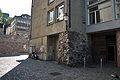
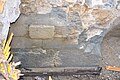
Remains of the old city wall at Hirschengraben, today in the basement of the Zurich Central Library

Limmat-side retaining wall of the Lindenhof or the remains of the wall of the Roman fort and the Carolingian , later Ottonian royal palace .

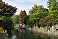
Bauschänzli , view from the Quaibrücke
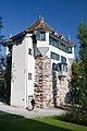
The Hardturm on the Limmat, built between 1200 and 1300 , is now used as a residential building.
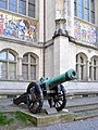
32-pounder bronze cannon, battery piece with the gun barrel designation "MERCURIUS". Cast by Hans III Füssli in Zurich in 1678; the fittings were forged by the sword smith and city locksmith Jakob Herder. Exhibited in the courtyard of the National Museum in Zurich.


Pictures of still existing aristocratic towers in the old town
The Glentnerturm

The Bilgeriturm on Neumarkt

The fountain tower

The Grimmenturm on Neumarkt

Grimmenturm around 1836
The “stone house” at the former Lindentor, residential tower of the Manesse and von Meiss families


Historical pictures of the city fortifications

The Augustinertor and the frog pit

The raceway gate with bulwark

The wave mountain

The Grendeltor on an engraving by HJ Kull

The Oberdorftor

The Niederdorftor with Vorwerk

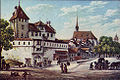
The Lindentor with bulwark
The Kronentor with Vorwerk

The new tower or tripe tower

The Tiefenhof linden tree on the Fröschengraben with the abbess tower / workshop tower around 1829

The Crown Gate 1827

The scratching tower and the building garden hill around 1871

The Crown Porte 1774

Bulwark "zur Katz" from the north, sepia drawing by Emil Schulthess , 1834/1835
A contemporary view of the cannon position "zur Katz" at today's Old Botanical Garden with a view of Enge-Zürichsee-Albis


Historical photographs of the city fortifications

The heretic or witch tower before 1878

The Rennweg gate before 1865

Rennwegtor 1865, shortly before the demolition
The Oetenbach bulwark before 1903

The frog pit with the scratching tower around 1864

The scratching tower with the building garden around 1877


Web links
- Burgenwelt: City fortifications of Zurich
- Summary of curriculum vitae fortress engineer Hans Georg Werdmüller (PDF; 2.8 MB)
Individual evidence
- ↑ A double row of palisades protected the Limmat runoff on the lake side, the «Schwirren». Lake fortifications near the shore, which should prevent enemy ships from landing, are generally referred to as buzzing - the most important are at Arth , Brunnen and Stansstad . They are derived from Letzinen , which mostly used topographical features in the form of hedges, wooden fences, palisades and later stone walls with trenches .
- ↑ From Middle High German swir 'Uferpfahl'; See Schweizerisches Idiotikon Vol. IX Sp. 2132, Article Schwir , especially meaning 1aλ column 213.
- ↑ From Old High German grintil or Middle High German grindel, grendel , 'bar, crossbar, bar, barricade, drawbar, plow tree'; For more information see Schweizerisches Idiotikon Vol. II Sp. 757, Article Grendel , Bed. 1.
- ↑ The Hardturm was part of the Letzimauer , which was an outbuilding of the earlier city fortifications of the Reichsvogtei Zurich, and at that time was far outside the actual city wall . This line of defense led from the Hardturm on the left bank of the Limmat to Friesenberg Castle on the Uetliberg. The Letzimauer was paired with a defensive moat , which should have given the street Letzigraben its name. The Letzistrasse still reminds of the extension of this defensive line to the Zürichberg on the right side of the Limmat .