
Bauschänzli
| Bauschänzli | ||
|---|---|---|
 |
||
| Waters | Limmat | |
| Geographical location | 683 370 / 246902 | |
|
||
| length | 60 m | |
| width | 40 m | |
| surface | 0.2 ha | |
| Highest elevation | 2 m | |
| Residents | uninhabited | |

The Bauschänzli ( Zurich German Buuschänzli [ˈbuːˌʃæntslɪ] , “small Bauschanze”) is a public square on an artificially created river island in the center of the city of Zurich .
Location and origin of name
The name comes from the former building site and Bauhaus in the former Kratzquartier on the left bank of the Limmat and on Lake Zurich . Today the Bauschänzli is located in District 1 in the immediate vicinity of the town hall , the « Frauenbadi » and the Quaibrücke . It is accessible from the Stadthausquai via a footbridge. On Johann Heinrich Vogel's plan of the Statt Zürich including the same fortification works from 1705 there is the name “Schänzli im See”.
history
Prehistoric settlement

In prehistoric times, the area near the lake basin was densely forested, the shore was rich in bays, and with the small and large Hafner there were two small islets inhabited by people in Lake Zurich not far from today's shore. There were probably several, only temporarily inhabited villages in the vicinity of the Bauschänzli and the Quaibrücke. Other settlement areas under the embankment in the Riesbach , Enge and Wollishofen quarters (in Haumessergrund) and Alpenquai have only been partially archaeologically researched. The currently best researched epoch of the settlements in the lake basin near Zurich is the cultural layer of the Pfyn culture (3850–3450 BC). So far ten villages of the Pfyner culture have been identified in the urban area, which were probably not inhabited at the same time.
More than 6000 years ago, the first wetland settlements - referred to by Ferdinand Keller as pile dwellings - were built near the water in the vicinity of the Bauschänzli , the remains of which were largely excavated in the 1860s as part of Arnold Bürkli's quay constructions. Under the outer walls of the building jump, up to the Quaibrücke, a stone and bronze age pile field stretched, which was probably documented by Ferdinand Keller around 1868/69. The layers of waste from the population of that time can be seen in places as small mountains of witnesses with brown cultural ribbons. The archaeological diving team of the city of Zurich has carried out investigations since the 1960s and was able to detect remarkably early traces of early history farmers on the lake shores. The settlement period is based on the period from 4100 BC. Until 1000 BC Dated; animal bones, hazelnut shells, charcoal, flint chips and ceramic shards were found in the deposits . The oldest ceramic shards date from around 4000 BC. BC, whereby two small shards clearly stand out from the other finds: They show typical decorations that are otherwise only known from Liechtenstein.
Medieval city fortifications

Together with the “zur Katz” bulwark , the Schanzengraben and the Lindenhof , the Bauschänzli is one of the last surviving relics of the baroque city fortifications and was probably completed in 1660 as the “Schänzlein in dem Wasser” (Schänzlein in dem Wasser).
Under the impression of the Thirty Years' War , the Zurich Council decided to fortify the city on a large scale according to the most modern knowledge of the time. With the council decision to build the hill in 1642, the new construction of the city fortifications was approved and an advisory commission was set up by Mayor Salomon Hirzel . After a lengthy evaluation of the most varied of fortification systems , Johann Georg Werdmüller's project was no longer built as a curtain wall, but as a contemporary Sternschanze, thus anticipating the groundbreaking construction method (Vauban fortress) by Sébastian le Prestre de Vauban (1633–1707). Expectant Müller's project of Lake Zurich took over at the outflow existing Limmat mounting that Grendeltor and its palisades , the so-called "buzz", as well as those already on the murerplan shown 1576 semicircular tower from the year 1540/41 the opposite work space ( "Steinhof") of the stonemasons and carpenters. These parts of the existing city fortifications were expanded from 1657 to include the pentagonal Ravelin "Kratz" in the Limmat. The bulwark, open on the city side, was connected to the Kratzquartier or the “Bauhaus” by a footbridge with a drawbridge. Large parts of the Kratzquartier had served as a work yard, which is why the house of the town's "builder" stood here, which was converted into a town house at the beginning of the 19th century.
Conversion as an urban recreational area


In 1747 eleven trees were planted on the Bauschänzli, which can be seen in the etching Von dem Helmhaus zu Zürich against the Bau-Haus by Johann Balthasar Bullinger and the colored city map (1788/93) by Johannes Müller. When the state property was divided up between the canton and the municipality in 1804 , the jumps initially remained state property. Only in 1841 did the Bauschänzli become the property of the city , with the stipulation that it had to remain an undeveloped public space in the long term . Despite the peaceful use of the facility, the new owner is urged by the military commission to «plant young trees in such a way that a horse-drawn gun can go round unhindered». Plans and drawings from that period show the Bauschänzli with a wide variety of gardens. Contemporary photographs secure the representation on Franz Schmid's picturesque plan of the city of Zurich and its surroundings from 1846, which shows a tall tree population with a large poplar pyramid in the middle.
At the latest when the city fortifications were razed in 1834, the former ski jump was also used as a vegetable garden by the city architect . With the demolition of the Kratzquartier, these remains of the city fortifications should also be removed; the new town house planned here was built between 1898 and 1900 next to the Fraumünster . In 1842 the city of Zurich replaced the drawbridge at the Bauhaus with an arched bridge, the "Bridge of Sighs". Since 1856, the Bauschänzli has been connected to today's Stadthausquai by a flat footbridge (renovated in 1988).
From 1835 to the construction of the Quaibrücke in 1882/84, the Bauschänzli also served as a landing stage for the steamships of today's Lake Zurich shipping company . On July 19, 1835, the steamship Minerva was launched near the «Holzschanze» on today's Utoquai. The invited guests gathered under the thunder of cannons and bells on the Bauschänzli. The "Minerva" set off on her maiden voyage to Rapperswil at exactly 11 o'clock .
The Bauschänzli today
In 1907 the city council approved a request from Eduart Krug, landlord of the "Metropol", to set up a beer garden on the Bauschänzli, after the city's "Promenade Commission" had approved the matter. The farm building was built in 1934 by the city master builder Hermann Herter, and the outer walls were renovated in the winter of 2001/2002 with the help of the cantonal preservation authorities. Originally a café house should have been built on the river island - as a beer garden with around 700 seats, the Bauschänzli is one of the largest among Europe's garden restaurants.
With the renovation work - amounting to 3.9 million Swiss francs - during the first half of 2006, the island was included in the municipal “Plan Lumière” and has been subtly illuminated in the evenings since then. In order to meet the criteria of environmental compatibility with energy-optimized luminaires with an energy consumption of 350 kWh / year and to avoid light pollution , there is no lighting in late autumn and winter (as long as the deciduous trees have no leaves). The outside area of the self-service restaurant, which has only been open in summer since 1991, as well as the “Limmatblick” restaurant and the new “Schänzli Bar” have also been redesigned. With its total area of 1835 m², the Bauschänzli also serves as the venue for the Zurich Oktoberfest and as the location for the Circus Conelli . The Zurich Oktoberfest first took place in 1995, initiated by the Zurich restaurateur Fred Tschanz. Since the redesign until the end of 2018, his company has been running the restaurant on the Bauschänzli.
So that the tree population can develop sustainably despite intensive use, a new concept for the protection of the trees was developed. The chestnut species Aesculus hippocastanum (Baumannii) with a long flowering period as well as few spiny fruits and fruit fall replaced the sick trees. In the course of the first phase of renovation, the chestnut trees on the east side, along the Limmat, were replaced and the largest possible trees were planted so that the typical beer garden character is retained. The trees on the west side will be replaced in a later stage, depending on the health of the weakened tree population. The newly planted trees received a tree protection that prevents compaction in the root area and is partly combined with a bench. Tree protection regulations specially developed for the Bauschänzli ensure that the young trees are preserved.
gallery

Wellenberg , Grendeltor and the presumable predecessor of the Bauschänzli in Christoph Silberysen's Swiss Chronicle , 1576
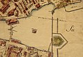
The upper Limmatraum on the Müllerplan from 1790, at the top right the Grendeltor with the buzzers and at the lower edge of the picture the Bauschänzli

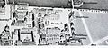
The Kratzquartier and the Bauschänzli in the city model by Hans Langmack, around 1800
"Picturesque plan of the city of Zurich and its surroundings" around 1846
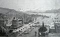
Grandhotel Bellevue, on the right the Bauschänzli, 1890


Web links
- Transformations in Zurich
- Underwater archeology of the city of Zurich: sites
- Swiss National Museum : special exhibition “The pile dwellers”, images of the finds
- Bauschänzli on the ETHorama platform
Individual evidence
- ↑ Stadthausquai, the Zürcher Frauenbadi in the Limmat
- ↑ a b c d e f g Redesign of the outside area of the Bauschänzli restaurant, Zurich's old town. Documentation for the reopening on May 9, 2006. Published by the property management of the City of Zurich, May 2006.
- ^ Office for Urban Development of the City of Zurich: Information board Euro08 platform
- ↑ Pile dwelling settlement is an outdated archaeological term that has been replaced in the circumalpine region by the newer term wet soil settlement .
- ^ Underwater Archeology of the City of Zurich: Projects & Evaluations ( Memento of April 9, 2012 in the Internet Archive ), accessed on February 9, 2009
- ↑ a b Gang dur Alt-Züri: Das Bauschänzli on Stadthausquai , accessed on February 6, 2009
- ↑ A double row of palisades protected the Limmat runoff on the lake side, the «Schwirren». Lake fortifications near the shore, which should prevent enemy ships from landing, are generally referred to as buzzing. They are derived from Letzinen , which used topographical features.
- ↑ a b Neue Zürcher Zeitung (November 29, 2003): The most beautiful “building district” in Switzerland ( memento of September 17, 2008 in the Internet Archive ) , accessed on November 8, 2008
- ↑ In 1846 the art dealer Hans Felix Leuthold published the picturesque plan of the city of Zurich and its surroundings drawn by Franz Schmid . Schmid (1796–1851) came from Schwyz and is considered one of the most important panoramic draftsmen of his era.
- ↑ A hundred years. Pictures from the history of the city of Zurich from 1814–1914 . Zurich 1914/1915.
- ↑ Bauschänzli ( memento of September 10, 2012 in the web archive archive.today ), accessed on February 8, 2009
- ↑ Media release by the City of Zurich (May 9, 2006): The newly designed Bauschänzli is open again ( Memento from September 10, 2012 in the web archive archive.today ) , accessed on February 6, 2009
- ↑ The Müllerplan (1794) served the architect Hans Langmark as the basis for his detailed model of the city of Zurich, on which he worked for 22 years; In 1942 it was acquired by the city of Zurich. It is exhibited on the ground floor of the Building History Archive of the City of Zurich ( Memento from May 27, 2011 in the Internet Archive ) in the “zum Rech” building at Neumarkt 4 and is freely accessible during opening hours.