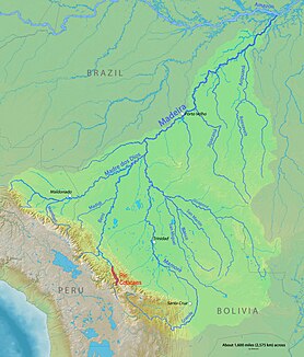
Río Cotacajes
| Río Cotacajes | ||
| Data | ||
| location |
|
|
| River system | Amazon | |
| Drain over | Río Alto Beni → Río Beni → Rio Madeira → Amazon → Atlantic | |
| Confluence of |
Río Sacambaya and Río Negro 16 ° 49 ′ 49 ″ S , 66 ° 48 ′ 55 ″ W |
|
| Source height | 1380 m | |
| muzzle |
Río Alto Beni Coordinates: 15 ° 56 ′ 9 ″ S , 66 ° 52 ′ 9 ″ W 15 ° 56 ′ 9 ″ S , 66 ° 52 ′ 9 ″ W. |
|
| Mouth height | 543 m | |
| Height difference | 837 m | |
| Bottom slope | 6.7 ‰ | |
| length | 125 km (as Sacambaya-Cotacajes: 263 km) | |
The Río Cotacajes is a tributary of the Río Beni and is located on the eastern slopes of the Andean Cordillera in the South American state of Bolivia .
The Río Cotacajes rises on the southeast edge of the Serranía de Sicasica , has a total length of 264 kilometers from the source of the Río Tallija and belongs to the river system of the Amazon . From its source downstream, the river is first named Río Tallija (27 km), then Río Leque (35 km), then Río Ayopaya (40 km), and then Río Sacambaya (37 km). The river bears its name "Río Cotacajes" from the union of Río Sacambaya and Río Negro (Cochabamba) and has a length of 125 kilometers as " Río Cotacajes ". At its mouth, the Río Cotacajes joins the Río Santa Elena and then bears the name Río Alto Beni .
Individual evidence
- ↑ Recursos hidricos superficiales ( Spanish )
Web links
- Cocapata creció y ya es el municipio 46 In: Los Tiempos March 22, 2009 (Spanish)
