Río Petrohué
| Río Petrohué | ||
|
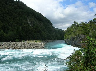
The waterfalls of the river in the upper reaches. In the background the Osorno . |
||
| Data | ||
| location | Región de los Lagos ( Chile ) | |
| River system | Río Petrohué | |
| origin |
Lago Todos los Santos 41 ° 8 ′ 27 ″ S , 72 ° 23 ′ 59 ″ W |
|
| Source height | 178 m | |
| muzzle |
Reloncaví Fjord Coordinates: 41 ° 23 ′ 12 " S , 72 ° 18 ′ 28" W 41 ° 23 ′ 12 " S , 72 ° 18 ′ 28" W. |
|
| Mouth height | 0 m | |
| Height difference | 178 m | |
| Bottom slope | 4.9 ‰ | |
| length | 36 km | |
| Catchment area | 2644 km² | |
| Drain |
MQ |
278 m³ / s |
|
Narrow gorges and steep, densely overgrown bank slopes shape the upper reaches of the river |
||
|
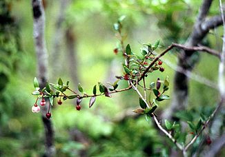
Chilean guava ( Ugni molinae ), at the "Saltos de Petrohué" waterfalls |
||
|
Male tornado duck. This species breeds in the Petrohué River |
||
Río Petrohué is the name of a river in the southern Chilean lake district .
It is the only outflow from Lake Todos los Santos to flow into the Reloncaví Fjord after 36 km in a wide delta . Despite its short length of only 36 km, the mean discharge is relatively high at 278 m³ / s. This corresponds roughly to the average flow rate of the Alpine Rhine into Lake Constance . During its course, first in a south-westerly and then in a southerly direction, the Río Petrohué receives only a few smaller streams. The river probably also absorbed water from Lake Llanquihue up until historical times , but this drainage was shifted by volcanic activities of the Osorno and Calbuco . About 6 km after the river leaves the lake, it falls over some basalt cliffs in several thresholds, a total of over 20 m in depth. In the upper reaches, the river has usually cut deeply into the volcanic deposits, so that many sections of the river are limited by steep bank slopes and are difficult to access. In the lower reaches, the river widens, branches out into various channels separated by sediment banks and finally flows into a wide, often branched boulder delta.
The water quality of the Río Petrohué has so far been excellent throughout its entire course due to the extensive lack of pollution factors. The strong increase in excursion, fishing and water sports tourism, especially in the area of the waterfalls, could, however, lead to a deterioration without accompanying measures.
The upper and middle reaches of the river lie in the oldest Chilean national park Vicente Perez Rosales . The entire course of the river lies within the vegetation of the Valdivian rainforest, whose dense, evergreen vegetation characterizes its river banks.
climate
The climate is cold-temperate. The area lies in the zone of the southern west wind drift , the climate of which is characterized by frequent strong westerly winds, moderately cold winters, moderately warm summers and annual rainfall of around 3000 mm / m². In summer the temperatures reach over twenty degrees, in winter they drop to 5–7 °. Frost days are rare, even snow only falls on a few days and usually does not stay for a long time. Since the river mainly contains water from Lake Todos los Santos and melt water from the surrounding mountains, it does not heat up above 15 ° Celsius; in August it is coolest with an average of 8 °. Only in the area of some hot springs are the water temperatures significantly higher.
flora
The banks of the Río Petrohué are lined with the dense vegetation of the Valdivian rainforest, the main tree of which is the Coihue ( Nothofagus dombeyi ), an evergreen pseudo beech species. Three other representatives of this genus occur in the area of the river, but are less common. Among the conifers , the most impressive is Fitzroya cupressoides , the Patagonian cypress, which can reach heights of growth of over 50 m and a very old age. The fruits of the Chilean guava ripen in autumn and are then sold as fresh fruit or processed into jam. Overall, the flora of the Valdivian rainforest is extremely species-rich and diverse.
fauna
There are 30 species of mammals in the vicinity of the river, of which the nutria and the southern river otter are directly water-bound and occur in the river system of the Río Petrohué. The avifauna is also abundant, but most of the birds live in the hinterland of the river. But is characteristic of the river itself, the Torrent Duck , which breeds on the edge of the river and can also be observed in the area of the falls. Baird sandpipers can occasionally be seen on the gravel banks of the less disturbed lower reaches, and red-breasted fishermen sitting on overhanging branches over calmer stretches of water . The long-winged steamship duck occurs in the estuary area, which is already heavily influenced by the ocean .
Originally the Río Petrohué only four species were native to the over- and middle reaches: Perca trucha , a Bar Chart ( Percichtys trucha ), which can reach a length of 40 cm, Bagre ( Trichomycterus sp. Areolatus ?), A trichomycteridae which panchax Peladilla ( Aplochiton taeniatus ), as well as the New World earfish Basilichthys australis , which is endemic to Chile and is called in the Pejerrey region . As its name suggests (Pejerrey = king fish), the latter was particularly valued as a food fish. The lower reaches and the estuary were and are more species-rich due to the oceanic influence.
Today, alien species predominate in the lake and river system, such as brown trout , rainbow trout , Atlantic salmon , silver salmon and king salmon . The originally North Pacific king salmon has developed self-sustaining populations and new migration traditions since specimens likely escaped or were released from aqua farms in the 1980s. Rainbow trout and brown trout are the most common fish in the Petrohué and most other Chilean rivers today. They make up more than 80% of the biomass in fish and are increasingly displacing the original fish fauna.
Others
The Río Petrohué is considered one of the best fishing spots in Chile. It owes this reputation only to species that were not originally native to the river system. The representatives of the salmonids , which are so popular with the anglers , did not appear in all of South America. The river is also becoming increasingly popular among water sports enthusiasts , rafters and white water canoeists, so that at its exit from Lago Todos los Santos, along the entire upper course, but especially at and near the waterfalls, a tourist infrastructure has been created and is being further expanded. It remains to be seen to what extent the negative consequences of this development can be contained through appropriate measures.
Web links
Individual evidence
- ↑ Doris Soto et al .: Establishment of Chinook salmon (Oncorhynchus tshawytscha) in Pacific basins of southern South America and its potential ecosystem implications . In: Revista Chilena de Historia Natural 80: 81-98, 2007. pdf span / engl.
- ↑ Todos los Santos - Archive ( Memento from April 13, 2013 in the web archive archive.today )
- ^ Establishment of Chinook salmon (Oncorhynchus tshawytscha) in Pacific basins of southern South America and its potential ecosystem implications . In: Revista Chilena de Historia Natural 80: 81-98, 2007. P. 85 pdf span / engl.
- ↑ Todos los Santos - Archive ( Memento from April 13, 2013 in the web archive archive.today )
- ↑ Fishbase (English)
- ↑ Doris Soto et al .: Establishment of Chinook salmon (Oncorhynchus tshawytscha). in Pacific basins of southern South America and its potential ecosystem implications . In: Revista Chilena de Historia Natural 80: 81-98, 2007. pdf span / engl.
- ↑ Doris Soto et al : Southern Chile, trout and salmon country: invasion patterns and threats for native species In: Revista Chilena de Historia Natural 79: 97-117, 2006 pdf span./engl.


