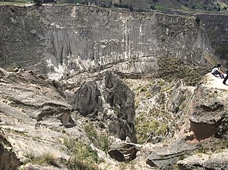
Rio Toachi
|
Río Toachi upper reaches: Río Zumbahua |
||
|
Río Toachi gorge near Zumbahua |
||
| Data | ||
| location |
|
|
| River system | Río Esmeraldas | |
| Drain over | Río Blanco → Río Esmeraldas → Pacific Ocean | |
| Headwaters |
Cordillera Occidental 1 ° 3 '52 " S , 78 ° 50' 34" W. |
|
| Source height | approx. 4250 m | |
| muzzle |
Río Blanco coordinates: 0 ° 6 ′ 42 ″ S , 79 ° 13 ′ 48 ″ W 0 ° 6 ′ 42 ″ S , 79 ° 13 ′ 48 ″ W. |
|
| Mouth height | approx. 330 m | |
| Height difference | approx. 3920 m | |
| Bottom slope | approx. 25 ‰ | |
| length | approx. 160 km | |
| Catchment area | approx. 2600 km² | |
| Right tributaries | Río Sarapullo , Río Pilatón , Río Memé | |
| Reservoirs flowed through | Toachi Dam | |
| Big cities | Santo Domingo de los Colorados | |
| Small towns | San Jose de Alluriquin | |
| Communities | Zumbahua , Sigchos | |
The Río Toachi is an approximately 160 km long left tributary of the Río Blanco in northwest Ecuador .
River course
The Río Toachi rises in the Cordillera Occidental , almost 25 km south-southeast of the Caldera Quilotoa at an altitude of about 4250 m . It flows through the mountains in a predominantly northerly direction. After about 13 km he passes the village of Zumbahua . The river is called in the upper reaches, up to the confluence of the Río Tigua at river kilometer 132, Río Zumbahua . The Río Toachi flows east past the Quilotoa crater. At river kilometer 105 he passes the village of Sigchos to the west . At river kilometer 55 the Río Sarapullo meets the Río Toachi coming from the southeast. After another 10 kilometers, the Río Pilatón joins the Río Toachi at La Unión del Toachi , also coming from the right. This then turns towards west-northwest, later to the northwest. The Río Toachi flows through the western foothills of the mountains and passes the small town of San José de Alluriquín . It finally leaves the mountains and flows along the northern outskirts of the provincial capital Santo Domingo de los Colorados through the coastal lowlands in northwest Ecuador. After another 20 kilometers, the Río Toachi meets the Río Blanco. One and a half kilometers above the mouth, the Río Memé meets the Río Toachi on the right. The E20 highway runs along the river between La Unión del Toachi and Santo Domingo de los Colorados .
Catchment area
The Río Toachi drains an area of an estimated 2600 km². The catchment area extends over a length of 80 km along the ridge of the Cordillera Occidental and is flanked to the east by the Illinois , Corazón and Atacazo volcanoes . In the southwest the catchment area borders on that of the Río Vinces , which drains the western flank of the Cordillera Occidental.
Toachi-Pilatón hydropower project
The project is being implemented under the management of CELEC (Corporación Electrica del Ecuador). Work began in 2011 at the latest. There were various delays and interruptions during the construction phase. The commissioning of the various power plants is planned between the end of 2019 and 2021.
Parts of the facility have already been completed. The project includes a weir ( ⊙ ) on the Río Pilatón, 14.5 km above its confluence with the Río Toachi. From this part of the water reaches a settling tank. From there, a 5.9 km long tunnel and an attached water lock lead the water to the Sarapullo power plant , a cavern power plant with three 16.3 MW Francis turbines . From this a 470 m long drainage canal leads to the Toachi Dam reservoir ( ⊙ ). The barrier structure forms a 59 m high concrete gravity dam. The flood relief is designed for 1200 m³ / s. Above the dam, the Río Sarapullo flows into the Río Toachi. There is a small hydropower plant with a 1.4 MW Francis turbine below the dam. This should use the ecologically necessary minimum runoff of 4 m³ / s for the downstream course of the river. The remaining amount of water is fed to another cavern power plant , the Alluriquín power plant , via an 8.6 km long tunnel and connected moated castle ( ⊙ ) . This is equipped with three 68 MW Francis turbines. A 500 m long drainage tunnel then leads the water back to the Río Toachi ( ⊙ ). The discharge point is about 2 km below the confluence of the Río Pilatón. The total installed capacity of the hydropower project is 254.4 MW.
![]() Map with all coordinates: OSM | WikiMap
Map with all coordinates: OSM | WikiMap
Individual evidence
- ↑ a b Toachi Pilatón . CELEC. Retrieved March 1, 2019.
- ↑ a b c Toachi-Pilatón Dam (Ecuador) . Lombardi SA. Retrieved March 1, 2019.
- ↑ Toachi - Pilatón hydroelectric project will start operation in 2021 . www.bnamericas.com. 1st March 2019.
