Berdyansk Raion
| Berdyansk Raion | |
| (Бердянський район / Berdjanskyj rajon) | |

|

|
| Basic data | |
|---|---|
| Oblast : | Zaporizhia Oblast |
| Administrative headquarters : | Berdyansk |
| Area : | 1,776 km² |
| Residents : | 25,680 (2015) |
| Population density : | 14.46 inhabitants per km² |
| KOATUU : | 2320600000 |
| Municipalities : | 8th |
| District administration | |
| Address : | пр. Перемоги 3 71100 м. Бердянськ |
| Rajonsvorleiter: | Stanislaw Frolov |
| Website : | Information is missing |
| Overview map | |

|
|
| Statistical information | |
The Berdjansk Raion (Ukrainian Бердянський район / Berdjanskyj rajon ; Russian Бердянский район / Berdjanski rajon ) is an administrative unit in the Zaporizhia Oblast in southeastern Ukraine . The center of the raion is the city of Berdyansk , but this is not part of the raion itself.
geography
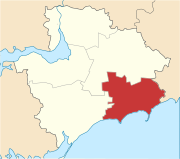
The Rajon is located in the southeast of the Zaporizhia Oblast , it borders in the north with the Rajon Bilmak , in the northeast for a short distance with the Rajon Nikolske (in Donetsk Oblast ), in the east with the Rajon Manhusch , in the south with the Sea of Azov , in West to the Prymorsk Raion and in the northwest for a short distance to the Chernihivka Raion . By Rajon flow the Berda (Берда) that Obytitschna that (Обитічна) Kiltytschtschja that (Кільтиччя) Burtytschtschja (Буртиччя) and Berestowa (Берестова), extends to the south the Berdyansk Spit (Бердянська коса) in the Sea of Azov, the area is flat with altitudes between 10 and 200 meters (highest elevation 241 meters) and is characterized in the south by the Black Sea lowlands , in the north extends the Azov highlands .
history
The Rajon was created in 1923 and was initially called Novoslawiwka Rajon (the main town was Novoslawiwka - today Ossypenko ), in 1925 Berdyansk became the capital and the Rajon was changed to its current name, then changed to Ossypenko Rajon in 1939 after the main town was renamed . After the occupation by German troops, the Rajonsgebiet was incorporated into the Reichskommissariat Ukraine in 1942 and was located here in the general district of Dnepropetrovsk , Berdjansk district . After the end of the Second World War it came back to the Soviet Union / Ukrainian SSR , since 1958 it bears its current name again, since 1991 it has been part of today's Ukraine. Between the end of 1962 and 1965, Prymorsk Raion was part of the Raion area.
Administrative structure
At the communal level, the Rajon is divided into a settlement council, a rural municipality and 8 district councils, each of which is subordinate to individual localities.
The administrative area includes:
- 1 urban-type settlement
- 35 villages
- 1 settlement
Urban-type settlement
| Urban-type settlements | ||
|---|---|---|
| Surname | ||
| transcribed in ukrainian | Ukrainian | Russian |
| Andriivka | Андріївка | Андреевка (Andrejewka) |
Villages and settlements
| Villages | |||
|---|---|---|---|
| Surname | Parish assignment | ||
| transcribed in ukrainian | Ukrainian | Russian | |
| Andriwka | Андрівка | Андровка (Androwka) | Andriwka |
| Azovsk (until 2016 Lunacharske ) | Азовське (Луначарське) | Азовское (Azovskoye) / Луначарское (Lunacharskoe) | Azovsk |
| Berestowe | Берестове | Берестовое (Berestowoje) | Berestowe |
| Dachno | Дахно | Дахно | Andriivka |
| Derevetske | Деревецьке | Деревецкое (Derewezkoje) | Chervon pole |
| Dmytrivka | Дмитрівка | Дмитровка (Dmitrowka) | Dmytrivka |
| Dolynske | Долинське | Долинское (Dolinskoje) | Dolynske |
| Dowbyne | Довбине | Долбино (Dolbino) | Berestowe |
| Hlodowe | Глодове | Глодово (Glodowo) | Berestowe |
| Ivanivka | Іванівка | Ивановка (Ivanovka) | Andriivka |
| Kalaytanivka | Калайтанівка | Калайтановка (Kalaitanowka) | Berestowe |
| Kosa | Коза | Коза | Dolynske |
| Krymka | Кримка | Крымка (Krimka) | Dolynske |
| Kulykiwske | Куликівське | Куликовское (Kulikowskoje) | Novopetrivka |
| Malynivka | Малинівка | Малиновка (Malinowka) | Berestowe |
| Mykolaivka | Миколаївка | Николаевка (Nikolayevka) | Berestowe |
| Novoivanivka | Новоіванівка | Новоивановка (Novoiwanowka) | Berestowe |
| Novopetrivka | Новопетрівка | Новопетровка (Novopetrowka) | Novopetrivka |
| Novosilske | Новосільське | Новосельское (Novoselskoye) | Andriivka |
| Novosoldatske | Новосолдатське | Новосолдатское (Novosoldatskoje) | Berestowe |
| Novotrojitske | Новотроїцьке | Новотроицкое (Novotroitskoye) | Novotrojitske |
| Olenivka | Оленівка | Оленовка (Olenowka) | Dolynske |
| Ossypenko | Осипенко | Осипенко (Ossipenko) | Ossypenko |
| Polousivka | Полоузівка | Полоузовка (Polousowka) | Andriwka |
| Radywoniwka | Радивонівка | Радивоновка (Radiwonowka) | Berestowe |
| Sachno | Сахно | Сахно | Andriivka |
| Shevchenka | Шевченка | Шевченко (Shevchenko) | Dmytrivka |
| Shevchenkoe | Шевченкове | Шевченково (Shevchenko) | Dolynske |
| Sofiivka | Софіївка | Софиевка (Sofievka) | Andriivka |
| Staropetrivka | Старопетрівка | Старопетровка (Staropetrovka) | Novopetrivka |
| Chervon pole | Червоне Поле | Червоное Поле (Tscherwonoje Pole) | Chervon pole |
| Trojany | Трояни | Трояны | Andriwka |
| Trojizke (until 2016 Karla Marxa ) | Троїцьке (Карла Маркса) | Троицкое (Troitskoje) / Карла Маркса (Karla Marxa) | Berestowe |
| Uspenivka | Успенівка | Успеновка (Uspenowka) | Andriivka |
| Settlements | |||
| Berdjanske | Бердянське | Бердянское (Berdjanskoje) | Chervon pole |

