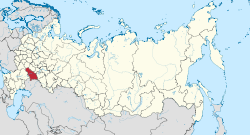
Pugachovsky rajon
| Rajon
Pugachovsky rajon
Пугачёвский район
|
||||||||||||||||||||||||||||||||||||||
The Pugachovsky rajon ( Russian Пугачёвский район ) is a raion in the Russian Oblast of Saratov . The administrative center is the city of Pugachev .
geography
Geographical location
The Pugachovsky rajon is located in the northeastern part of Saratov Oblast , about 250 kilometers east of the city of Saratov . The Rajon is located east of the Volga in the steppe at the western end of the Caspian Depression and is crossed by the Great Irgis .
Neighboring communities
| Duchownitski rajon | Ivanteevsky rajon | |
| Balakovsky rajon |

|
Pereljubski rajon |
| Balakovsky rajon | Krasnopartisanski rajon | Osinski rajon |
structure
The Rajon is divided into the municipality of Pugachev and nine rural communities with a total of 64 localities. The largest settlements are (as of 2006) :
- Pugachev 44,154 inhabitants (administrative center)
- Berjosowka (Берёзово) 1285 inhabitants
- Dawdowo (Давыдовка) 1430 inhabitants
- Zavolzhsky (Zavolzhsky) 2770 inhabitants
- Klinzowka (Клинцовка) 1070 inhabitants
- Old Porubeschka (Старая Порубежка) 1470 inhabitants
- Uspenka (Успенка) 1020 inhabitants
Web links
- Information from the Oblast on the Pugachovsky rajon (Russian or English)
Individual evidence
- ↑ Itogi Vserossijskoj perepisi naselenija 2010 goda. Tom 1. Čislennostʹ i razmeščenie naselenija (Results of the All-Russian Census 2010. Volume 1. Number and distribution of the population). Tables 5 , pp. 12-209; 11 , pp. 312–979 (download from the website of the Federal Service for State Statistics of the Russian Federation)
- ^ Pugachev district map

