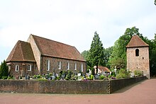
Rhaude
|
Rhaude
municipality Rhauderfehn
Coordinates: 53 ° 9 ′ 42 ″ N , 7 ° 34 ′ 15 ″ E
|
|
|---|---|
| Height : | 3 (1-3.1) m above sea level NHN |
| Area : | 4.96 km² |
| Residents : | 357 (1970) |
| Population density : | 72 inhabitants / km² |
| Incorporation : | 1st January 1973 |
| Postal code : | 26817 |
| Area code : | 04952 |
|
Location of the municipality of Rhauderfehn in the district of Leer
|
|
Rhaude is a district of the East Frisian community Rhauderfehn and is one of the oldest settlements in Overledingerland .
history
The East Frisian local historian Otto Galama Houtrouw suspects that Rhaude was founded during the time of Charlemagne . The village was possibly first mentioned as in Renuuidu as early as the 10th century . In the first secured documentary mentions of 1438 and 1439 the place is called Rawede or Rawide .
The Rhauder church dates from the 14th century.
During the Thirty Years War , Peter Ernst II of Mansfeld invaded the Overledingerland from Holland via Münster with 3,000 men on foot and 3,000 horsemen (1622). Rhaude and the neighboring town of Holte had to bear the burden of billeting. In 1637, Landgrave Wilhelm von Hessen and 7000 men moved up from the Munster. The Rhauder Schanze was stormed by General Rantfou.
In the 17th century, Rhaude was the starting point for the first beginnings of the colonists in the raised bogs to the south . Until the 19th century, the parish also remained the mother parish and parish for the neighboring moor colonies and Fehne.
The district of the old Geestdorf today covers an area of 496 hectares. The population is about 400.
On January 1, 1973, Rhaude was incorporated into the new municipality of Rhauderfehn.
people
Johann Christian Reil was born in Rhaude on February 28, 1759 . Reil was one of Goethe's personal physicians and is considered the father of general and integrative psychiatry and psychotherapy .
Web links
Individual evidence
- ^ Otto Galama Houtrouw: East Frisia. A historical and local hike towards the end of the princely period . Volume 1 and 2, Aurich 1889 and 1891. p. 193.
- ↑ a b local chronicles of the East Frisian landscape: Rhaude, community Rhauderfehn, district Leer . Retrieved October 28, 2015.
- ^ Federal Statistical Office (ed.): Historical municipality directory for the Federal Republic of Germany. Name, border and key number changes in municipalities, counties and administrative districts from May 27, 1970 to December 31, 1982 . W. Kohlhammer GmbH, Stuttgart / Mainz 1983, ISBN 3-17-003263-1 , p. 262 .


