
Ruinaulta
| Ruinaulta (Rhine Gorge) | ||
|---|---|---|
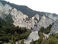
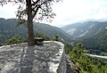
 Rhine loop seen from the viewing platform Il spir in the Ruinaulta with the RhB and pedestrian bridge between the Chli Isla in the center of the picture and the Isla Bella (left) |
||
| location | Graubünden , Switzerland | |
| Waters | Vorderrhein | |
| Mountains |
Glarus Alps Lepontine Alps |
|
| Geographical location | 743 203 / 185821 | |
|
||
| Type | canyon | |
| length | 13 km | |

The Ruinaulta or Rhine Gorge is a gorge up to 400 meters deep and around 13 kilometers long in the Vorderrhein between Ilanz and the mouth of the Hinterrhein near Reichenau in the canton of Graubünden in Switzerland . The Rhaeto-Romanic name 'Ruinaulta' is composed of the two words Ruina (scree slope , quarry) and aulta (high).
Emergence
The Ruinaulta was formed after the Flims landslide almost 10,000 years ago. At that time, more than 10 billion cubic meters of rock broke off between Flimserstein and Piz Grisch and buried the Vorderrheintal between today's villages of Castrisch and Reichenau under a mass of rubble several hundred meters thick.
Since the Vorderrhein could no longer drain away, a lake was dammed over a length of around 25 km. In the course of time, the river cut deep into the landslide masses and the resulting lake was able to flow away completely. What remained was the Ruinaulta with its steep limestone rubble cliffs in imposing erosion formations.
Access
The only continuous traffic route through the gorge is the Rhaetian Railway . A hiking trail to connect the existing trails from Reichenau to Trin Station and from Versam Station to Ilanz is being planned. In the gorge are the train stations of Trin , Versam - Safien and Valendas - Sagogn , which can be reached by road from the considerably higher situated villages. The southern road from Ilanz about Versam according Bonaduz runs high above the gorge, the main road 19 via the north Talpass of Flims . The Rhine Gorge and the surrounding communities are accessible via marked hiking trails.
Rafting trips are offered through the Ruinaulta .
The Punt Ruinaulta footbridge spans the Rhine at the Trin station . At the Valendas-Sagogn train station there is a road bridge that allows access to the train station from Sagogn.
Ruinaulta with the Rhaetian Railway

Vorderrhein near Versam-Safien station

View from the Islabord platform to the northeast. In front of the steep face of the Ruinas sut Crestaulta, the Rein Anteriur flows around the Chli Isla

View from the Islabord viewing platform in west-north-west direction above the Chrummwag

View from the artificial road Bonaduz-Versam towards Ilanz (near the Zault viewpoint)


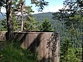
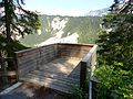
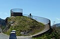
Viewing platforms
Seven platforms offer wide views of the Ruinaulta:
- Il spir near Flims-Conn, created 2006 by Corinna Menn
- Alix at Valendas
- Islabord on the road from Versam to the RhB Versam-Safien station
- Spitg on the east side of the Versamertobel
- Wackenau at the castle hill of Wackenau Castle
- Zault an der Strasse nach Bonaduz , created 2010 by Walter Bieler
- Crap Signina above Sagogn , created 2015
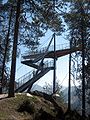
Il spir
Alix
Islabord
Spitg


Wackenau
Zault

Crap Signina


Varia
The local regional magazine is named after the Ruinaulta .
Web links
- Website Rheinschlucht - Ruinaulta
- Aerial view of the Ruinaulta
- Photos of the railway line through the Vorderrhein Gorge on eisenbahnen.at