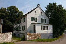
Riethrath Mill
The Riethrath Mill in Langenfeld - Richrath is a former watermill on the Riethrath Bach, which was awarded a monument in 1990 .
History of Riethrath
Presumably, Riethrath is also one of the founding places of the so-called declining Franconian land grab from the 6th and 7th centuries.
The Riethrather Hof and thus the location of Riethrath is first mentioned in a document in 1302. At that time half of the Riethrath Hof and in 1336 all of it fell to the Gräfrath Monastery , which from then on leased it. In 1513 the couple Engel [bert] and Gertrud von Rietrath leased the "Rietrather Hof und ein Kotten ibid" for themselves and their children. It is not documented when the courtyard was expanded to include a grinding mill.
The location of the mill
The Viehbach / Rietrather Bach flows in the main direction from Solingen in the east to Garath Castle in the west. Four water mills were operated in the Langenfeld area, simultaneously for several decades. The Krüdersheider oil mill is located on the upper course of the stream, known as the Viehbach, at today's city limits Solingen / Langenfeld; it is followed by the Schwanenmühle, which is the first to be documented in writing in 1341. Down the stream, the Götscher and Riethrath mills are located on the same body of water, now called Riethrather Bach. All four mill buildings are now only used for residential purposes.
The "Rietermühl" is shown on the map "Das Ambt Monheim" by Erich Philipp Ploennies from 1715 at its current location as a farm and mill. At that time both were on the right side of the stream. The course of the stream remained unchanged, only after the mill had stopped operating the stream was diverted and the mill pond disappeared.
The mill in the 19th and 20th centuries
Until the secularization in 1803, the farm remained in the possession of the Gräfrath monastery. In 1820 Jakob Michael Kreiskötter from Hilden acquired the Riethrather Hof and mill with 214 Prussian acres . In 1832 District Administrator Hauer from Opladen arranged for a check to be carried out to determine whether the Riethrath mill was in operation and whether it had to be re-assessed for tax purposes. In 1836 it says: "The Riethrath mill has long since fallen into disrepair beyond the tax bill." Apparently, Jacob Michael Kreiskötter had it restored in 1837 and the eight wall anchors with his initials and the year (JMKK 1 8 3 7) used today half hidden - can be seen on the south side. In any case, in 1843 it is noted in the files that the under- ground grinding mill has been renewed. In 1844 6 thalers were levied annually in tax for “two grinding courses and one barley course”. In 1850 the following is noted: 1 overturned water wheel, grinding stages: 1 wheat, 1 grain, 1 barley.
In 1857 the farm and mill were sold to the miller and baker Friedrich Wilhelm Klophaus, who expanded the property into a three-wing courtyard. In 1870 the tenant Friedrich Dorp ran the Riethrath mill, who is attested as a miller in the Götscher mill for the years 1872 to 1874.
The farm was managed until 1930. In 1957 the Riethrath mill was dismantled.
References and footnotes
- ^ A b c Rolf Müller: Stadtgeschichte Langenfeld Rheinland , Verlag Stadtarchiv Langenfeld 1992.
- ^ Document book Hilden
- ^ Kurt Niederau: Contributions to the history of Solingen (= anchor and sword. From the past and present of the city of Solingen. Contributions to its history, Vol. 5). Braun, Duisburg 1983, p. 7ff.
- ^ Erich Philipp Ploennies : Topographia Ducatus Montani (1715) . Edited and edited by Burkhard Dietz (= Bergische Forschungen , Vol. 20). Schmidt, Neustadt an der Aisch 1988.
- ↑ a b c Langenfeld city archives, holdings: Mayor's office Richrath, file on the taxation of the shipping trade and the mills .
- ↑ Here, “grain” means rye. The equation "rye = grain" was common in the areas where rye was the most widely grown type of grain.
- ^ Langenfeld Environmental Protection and Beautification Association: A guide through the built history of Langenfeld .
Coordinates: 51 ° 8 '28.8 " N , 6 ° 57' 14.8" E
