
Hardt (Langenfeld)
|
Hardt (Langenfeld)
City of Langenfeld (Rhineland)
Coordinates: 51 ° 6 ′ 48 ″ N , 6 ° 58 ′ 14 ″ E
|
||
|---|---|---|
| Height : | 55 m above sea level NN | |
Location of Hardt (Langenfeld) in Langenfeld (Rhineland) |
||

The Hardt is the location in the east of Immigrath (district of Langenfeld ) in the direction of Feldhausen and Wiescheid .
geography
The Hardt in Langenfeld is located on the right Rhenish middle terrace , which is also known as the Heide terrace. According to current maps of the urban area, the actual district of Hardt includes the lower part of Gladbacher Straße south of Bergische Landstraße , the western part of Hardt , the streets Am long Busch , Kaisersbusch , Zum Spürklenberg , Wacholderstraße , Hagebuttenweg and Leichlinger Straße east of the Cologne railway line –Duisburg . The Hardtbach rises and flows in the area of the A 542 and the A 3 , which crosses under the railway line in the area of Immigrather Platz . In the past, the term " Hardt " was also used to describe the forest that reached as far as the Schwanenmühle and belonged to the Dückeburg hunting area . In the 15th and 16th centuries there was a wood cooperative here for the use of the forest in the Hardt .
Today we associate with the Hardt primarily the road Hardt from the railway Troisdorf-Mülheim-Morsbroich-Opladen-Immigrath Rich Rath Speldorf the former Rhenish Railway Company of up behind the junction of the A3 , junction box Weg with its southern as northern Back streets. As far as Hardtstraße is found for Hardt street , it is only to distinguish it from the local legend of the same name.
Street history
The essential part of the history of Hardt is - as so often in Langenfeld - the history of a street. Today's road Hardt is identical to the B 229 . In sections it is called Hardt , Elberfelder Strasse , Landwehr and Ohligser Strasse . In the times when there were no fixed street names, it was also called Solinger Chaussee (1793), Solinger Straße (1836), Solinger Heerstraße (1848), Hitdorfer Heerstraße (1850), Elberfeld-Hitdorfer Chaussee (1851) and Solingen- Hitdorfer Provinzialstrasse (1885). For her very personal story, reference is made to the Provincial Road Elberfeld – Hitdorf , as it was called in other cities.
Originally, the Hardt road was only a beaten track , as was the mouse path , the oldest known trade route through Langenfeld and the Rhineland . The Hardt is probably not much older either, because north-south roads only make sense if it branches off somewhere to the east and west. A north-south connection that is now associated with the Hardt is the A 3, because of the Solingen Langenfeld junction already mentioned , although Solingen's city limits are still a good 2 km away from the motorway.
Incidentally, the Opladen - Langenfeld - Düsseldorf route of the A3 was its third construction phase and began in March 1931. On May 21, 1936, the part was finished and could be opened to traffic by Reich Minister Joseph Goebbels . But flying as early as September 1934 members of the International Road Congress in airship Graf Zeppelin , the line on what - Müller - a first-class propaganda for the Nazi had been state.

AWO day care center for the former weaving mill Theis

Art in the Hardt, sculpture swath rag
Assumption Day


Economic history
Timber industry
In earlier times, the forest was of great importance . The wood was used in particular as construction wood such as firewood , but also for furniture , tools , carriages and ships . In particular, from the Altenberger monastery , such as Gut Widdauen , a lot of wood came to Cologne as firewood and for club jumps . To protect the forest from overexploitation , brands or trademarks were set up early on. District Administrator Hauer explained their purpose in 1832 with the words:
In the duchies of Jülich and Berg , the names of those forests were " Gemarken or Erbbüsche " that belonged to a cooperative of several participants, each according to certain sub-ratios, and were usually managed independently by them under the chairmanship ("Holzgraf") of some of the larger partners who were specially authorized to do so . Their property had nothing in common with the quality of a church member. "
The large part of the Hardt once belonged to such a forest, which stretched between Hilden , Ohligs and Leichlingen (Rhineland) ( Hardtwald ). He also had names such as " gemarke van Rijchroede " (1367), " Rijchraeder Hart " (1420), " marken van Richrode " (1449) or " Richrather Gemarck " (1591). The earliest written mention dates from the year 1305, when the provost of the Gräfrath monastery acquired the right to clear clearing , the so-called "wood force" , for 7 marks . The wood cooperative was last mentioned in 1809 when the Holzgewalt company was sold. It finally came to an end with the "regulation of the Richrath brand division" on November 1, 1815. But years before that, the forest was considered to be spoiled and efforts were made to transform it into fertile landscapes and human settlements. Another attempt to reclaim the heather and wasteland was made by the community under Mayor Felix Metzmacher in 1913, when the forest was cleared and two farms were set up, namely the Heidehof and the Metzmacherhof .
Agriculture and craft
On the history of the people who lived on this street, part of an essay by the former school principal Peter Schmitz is quoted here, which can be found in the home book of the municipality of Richrath - Reusrath :
“ Anyone who wandered through our congregation in the first half of the 19th century found it slumbering in the deepest slumber. In the north and east, crossed by birch and fir forests , the colorful, shimmering heather spread like a large lake, which covered the barren sandy soil with its purple flowered apron out of grace and mercy. There was a calm over the wide, almost flat surface, as if the Lord God had finished his work of creation. Almost hidden in this Sunday silence stood frightened and dreaming isolated half-timbered houses , also smaller groups of houses, the sight of which today reminds you of long-forgotten days. A song of diligent work sounded out of them , without causing any misunderstanding in the holiday activities. The poor soil , which treated its earth children too neglectively , forced them to the loom or vice . In quiet homework , in the face of woman and child, the daily bread was earned with happy singing, in restless zeal and tenacious perseverance. In the west and south, too, where the more fertile soil created by the gravel deposits of old branches of the Rhine created better living conditions and golden fields of corn shone, the resulting greater population density forced some of the residents to look for a living through home industry . "
The text may sound a bit antiquated, but it accurately describes the living and working situation of the people in Langenfeld before the onset of industrialization . For the range of Hardt are Weber professions and suppliers for the Solingen blades industry detected primarily knife workers as " shell Schneider ", " Reider " for table knife or pen-knife , blade grinder , razor hollow grinder , razor blade grinder , sword-Leifer , pocket knife maker , scissors assemblers and inspectors , knife and scissors - Feiler as well as file cutters , next to them eyes pliesterer and Ausmacher. In order to represent the entire branch of business around the knife and blade manufacturing industry, the city also acquired the entire workshop equipment of the Wiescheider shell cutter Wilhelm Jacobs and set up his Kotten as an exhibition object in a glass exhibition hall in the Volksgarten next to the Wagner house in Langenfeld-Mitte .
Natural resources
Sand and gravel
In addition to agriculture and the home -based trade , the excavation , i.e. the exploitation of sand and gravel deposits in Langenfeld, in the area of the Hardtwald in Gladbach and in the Leichlinger Sandberge was important . Field railways were also used to transport the mined mineral resources . One of the small steam locomotives with two tipping lorries is shown on a greeting card from Immigrath in front of the Zur Hardt inn (opposite the junction between Gladbacher Strasse and Hardt ). Apparently, summarizes Müller, the means of transport must have been an attraction back then .
peat
Despite the large peat bog areas , the last preserved in Langenfeld is the Further Moor nature reserve , where the peat played . On the one hand it was due to a weak deposit, on the other hand the calorific value of the heather peat was not high enough. Therefore, in 1858, only four acres of peat cutting were statistically recorded.
industrialization
Hand weaving
The way into industry began with the processing of flax and wool . Textile processing was thus the second mainstay in addition to the manufacture of cutlery. These professional groups, who also worked from home, included the weavers in the most varied of forms when there were: cloth makers , linen weavers , wool weavers , cotton weavers , sheet weavers , silk , velvet and plush weavers , stocking weavers and weavers of silk and semi-silk ribbons . They were also to be found throughout the city, including in the Hardt . In 1852 there were 158 hand looms and 250 larger looms in Langenfeld . Six owners of larger looms have already been factory named because they were among the 250 looms of this type 92nd However, the first known owner of a textile factory in Langenfeld was a Mr. Höpker to Reusrath , which in 1819 already 60 looms his own called and 80 workers employed.
Machine weaving
In 1861, four years before the first steam engine was put into operation in Langenfeld, there were still 287 looms in private homes, although hand-weaving was already almost completely drained at that time. In 1895 just 63 people were still active in this trade . The big change came in 1865 with the locomobile steam engine acquired by Carl Theis Söhne . Why the initially successful Theis had to file for bankruptcy in 1874 is no longer understandable. Soon after it was shut down, however, another resumed production there. The "factory building" at that time has since been demolished and rebuilt instead of on the B 8 on Solinger Straße . It is the by Siegfried Dissmann named half-timbered building , which now houses the AWO - Altentagesstätte is housed.
Early industries
After this excursion into the great history of the city back to the Hardt : In 1872 the Neumann & Büren weaving mill with 130 looms settled in the Hardt . (von Galera mentions the year 1864 for the move to Langenfeld) Carl Hesselmann followed in 1873, making Hardt the second textile industry location in Langenfeld next to Mitte . Around 1900, the iron processing industry in Hardt with Kronprinz AG and Ernst Tellering & Co. , Höveler Kraft futtermittelwerke and a cardboard box factory were among the early industrial companies. In addition to other weaving mills, a ring kiln brickworks , a marble sawmill , the tube factory Höll , the Reusrath mills in Leyhausen , a flashlight powder factory and a poultry feed and dog biscuit factory were found across the city . Mention should continue in 1937 moved to Langenfeld company Wilhag, owner Wilhelmshagen Kamp , the caterpillar tractors , excavators , cranes and truck cranes , most recently under the name MFL - Maschinenfabrik Langenfeld created. The culture factory known as the showroom is located in its rooms today .
After 1945
In a difficult time after the Second World War , a new company started with the Ara shoe factory in Hardt in a division not yet based in Langenfeld. In order to be able to offer his customers not only shop window goods, the owner of several shoe shops quickly founded his own production company. He bought gas masks that had now become superfluous from Wehrmacht stocks , separated the textile straps and attached them to synthetic wood shoe soles in such a way that stable and durable sandals were created. In Ohligs , his products were torn out of his hands, says Müller, probably less because of their elegance, but because there was nothing else.
The Ara shoe factories today form the southernmost part of a large industrial and commercial area, which was designated as a relocation area and new settlement area for industry and commerce in 1953 , the industrial area East. It is located in the former Hardtwald of the Heideterrasse on the former city-owned Heidehof . The total area of the area is 240,000 square meters and was expanded by another 250,000 square meters after the closure of the Langenfeld operating part of Mannesmann AG . The companies based here today are very diverse, the former monostructure of iron processing and textile industry has been broken up. Furkamp I and II with another 470,000 square meters in total are further commercial locations today. There are also small areas on Hausinger Strasse and, more recently, on the 542 motorway .
Churches, art and culture
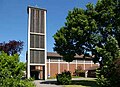
Parishes in the Hardt are today the Church of St. Maria Himmelfahrt, a Catholic church built in 1956 with exposed concrete and brick walls . The Erlöserkirche , an evangelical parish church built from dark rock , was consecrated as early as 1909 .
Since 2008, the former Rheinische Eisenbahngesellschaft , which essentially made industrialization in the Hardt possible, has been the sculpture "Die Schwadlappen" in the roundabout in front of the underpass under the Troisdorf-Mülheim-Morsbroich-Opladen-Immigrath-Richrath-Speldorf railway . In view of the centuries- long and ongoing economic history in the Hardt in particular, it is undisputed that this is not a memorial for the working population .
The Quartettverein Gladbach 1919 eV am Jansenbusch is one of the oldest still existing associations in the Hardt .
Individual evidence
- ↑ a b c d e f g h i j k l Rolf Müller, " Stadtgeschichte Langenfeld Rheinland ", Verlag Stadtarchiv Langenfeld 1992
- ^ VVV eV, home book of the community Richrath-Reusrath , Hense Druck 1928, Facsimile Verlag Rheinlandia 1986
- ↑ a b von Galera, Langenfeld (Rhld.), Von der Margrafschaft zur Stadt , Ofen, Langenfeld 1963
Districts: Langenfeld-Mitte | Immigrath | Richrath | Reusrath | Berghausen | Wiescheid
Locations and locations: Alt-Langenfeld | Brewhouse | Brandshof | Dückeburg | Feldhausen | Flachenhof | Fuhrkamp | Furth | Galkhausen | Ganspohl | Gieslenberg | Gladbach | Götsche | Götscher mill | Gravenberg | Hail cross | Hapelrath | Hardt | Hausingen | Hedge | Heinenbusch | Hoemann | Hucklenbruch | Hüsgen | Kämpe | Kaisersbusch | Limestone hedge | Katzberg | Cherry tree | Köttingen | Krüdersheide | Landwehr | Langfort | Corn flour | Neuburger Hof | Neurath | Ossenbruch | Rietherbach | Riethrather Hof | Riethrath Mill | Schelthoven | Schnepprath | Schwanenmühle | South | Stone rush | Stefenshofen | Turret | Virneburg | Wafert | Weißenstein | Widdauen | Angle | Wolfhagen | Customs House