
Leichlingen sand mountains

The Leichlinger Sandberge are located in front of the western edge of the Bergisches Land on the city limits from Langenfeld to Leichlingen . They are part of the Bergische Heideterrasse .
Location and origin
Those who used to hike through the sand pit in front of the steep drop of the Heidberg , which was "cut open" to Leichlingen , often discovered ammonites , fossilized cephalopods with limestone shells that lived in the Triassic , Jurassic and Cretaceous periods . As floating inhabitants of the open sea , their dead bodies formed the material for the white adhesive sand that was so popular in the glass and building materials industries . In order to extract this material from the former bay , today called Cologne Bay , in the open pit , almost all of the sand mountains were removed. They are, moreover, on the eastern edge of the heath terrace designated central terrace of the Rhine , which - in addition to raising the former seabed by tectonic forces - possibly across millions of years with its part in the special collection of fine white sand may have contributed.
Boulders in the sand mountains from the Moselle , Nahe and Lahn speak in favor of the Rhine helping to shape this landscape in front of the mountainous region. The Leichlinger Sandberge, as they have been called since around 1800, are today only preserved in three mountains (and half a Heidberg ) due to human activity . They are lined up in a north-south direction south of the B 229 , west of the Ziegwebersberg road and north of the Leichlinger Naturfreundehaus. The West limit the streets on Bruengersbroich , Heider Höfchen and Kapeller way to the highway A3 towards. These are from north to south, and this in the area of Wiescheid the Wenzelnberg , in Immigrath the Spürklenberg and the Kellerhansberg . Mountains that once belonged to the Sandbergen, such as the Block or the Stockberg, have only survived in street names. The heavily jagged mountains Spürklenberg and Wenzelnberg separate the streets Kapeller Weg and Auf dem Kurzenbruch , which lead to the Reinoldi Chapel in Solingen - Rupelrath .
The once rich sand deposits on the Leichlinger side facing the Ziegwebersberg road have now been almost completely dredged for the building materials industry and the glass industry . Today there is a large landfill in this area , which can be accessed via the A 542 motorway between Spürklenberg and Kellerhansberg . Despite considerable protests against the landfill, large parts of it have now been filled and have already been shut down. The rest of the Heidberg itself was declared a geological natural monument in 1983 and is thus protected from further human access. Despite this protection, natural erosion naturally continues. The best view of the geological layers of this cut mountain is from the street Am Stockberg .

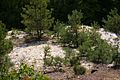
Well hidden: Heidberg natural monument

Leichlinger Sandberge: The Heidberg

Summit cross of the Wenceslas Hill
Object of desire: sand


from history
Langenfeld
Already on June 28, 1367 a "santcuyle" at "deme molenberge" of the Richrath district is mentioned. Since then, the extraction of sand in open-cast mining , in so-called sand pits / gravel pits, has been proven. However , it is not known exactly when the extraction of sand in the sand mountains began. In any case, around 1800 a gravel pond is reported for Gladbach . And in 1832, District Administrator von Hauer mentioned that there used to be an obligation to deliver 20 carts of sand (today one would speak of truck loads) to the government chancellery in Düsseldorf . This obligation was not lifted until the Napoleonic era in 1807.
When the need for white sand increased at the beginning of the 19th century , sand pits were set up in the area of Block , Kellerhansberg , Heidberg , Spürklenberg and Wenzelnberg . In this context, mention is made of the Immigrather companies Hülsbeck AG , Bergische Sandwerke GmbH , Immigrather Sandwerke Gebrüder Mismahl / "Mine yield in silver and adhesive sand" as well as a union of the Othello iron stone mine, management of the sand pit company at Kaisersbusch . Apparently, however, the expectations of some entrepreneurs were greater than hoped. The company Bergische Sandwerke GmbH, for example, went bankrupt again in 1906, as indicated by an advertisement from the Opladen Royal District Court on December 5, 1906 in the Opladener Zeitung. Other companies, on the other hand, prospered. As sales increased , new workers were always sought in the pits . For example, light railways with a gauge of 60 or 71 cm were built for the purpose of transporting the sand from the pits to Immigrath station , located on the western edge of the Hardt . In 1905, for example, the Othello union owned two steam locomotives with 25 HP and 30 HP and 50 dump trucks with a load capacity of 2000 kg each . And as early as 1908, the Mismahl brothers had a locomotive equipped with a 14 hp petrol engine . According to the maps of the Prussian New Admission, the railway lines ran via Gladbach to Immigrath station. The abandoned pits later served as landfills .
It should be added to the Immigrath - Wiescheider part of the sand mountains , that apparently only the purchase of the site and its reforestation by Mayor Felix Metzmacher prevented its complete destruction. On the Langenfeld side, the possibly archaeologically interesting areas around the Spürklenberg and the Kellerhansberg were excluded from mining. It is not reported whether the nobility from Gladbacher Hof still exerted influence due to the routing of the small railways across the courtyard.
Corpses
From the Leichlinger side were driven first, probably just around the year 1800, tunnels in the mountain to the white scattering and abrasive powders, as the special shell - sea sediments were also called to reach. When these tunnels were later rediscovered in open-cast mining , there was speculation about their importance and history. Some saw them as " robbers' nests ", others thought they were the work of the ancient Romans . Initially, the coveted "silver nests" were dismantled and the material was transported with the simplest of aids such as scoops , wicker baskets and horse and carts . Finally, by the owner of the sand operation, Karl Halbach , one of horse -drawn siding applied until about 1914 then the sand pit was a direct rail connection. From then on, three trains with up to 50 tipping lorries left the site every day . Operation of the mine was then discontinued in 1983.
The Wenceslas Hill
At 111.5 m above sea level, the Wenzelnberg is the highest point in Langenfeld. He became known beyond the city limits because of an end- stage crime committed there in the last days of the war . On April 13, 1945, 71 criminal and political prisoners were shot there in a ravine . It was 60 prisoners from the prison Remscheid - Lüttringhausen , four remand prisoners from the prison Wuppertal-Bendahl and seven in Ronsdorf incarcerated end forced labor . The men were no court ruling by a Gestapo - Detail shot and buried immediately. After an initial exhumation of the dead and a funeral on May 1, 1945, the town hall in Solingen-Ohligs those killed were again reburied . Since January 19, 1965, the dead man's final resting place has been the site of her murder again. Since then, the memorial has also been the gravestone in their cemetery .
The summit cross of the Wenceslas Hill is located above the memorial . Towards the location of Gravenberg is the elevated tank of Stadtwerke Langenfeld , the ceiling of which at 116.3 m still towers over the summit of Wenzelnberg. Not far away from the memorial is also the memorial for the fallen soldiers of the First World War and the Second World War , insofar as they were men from Wiescheid and Feldhausen .
The location of Gravenberg is presumably related to the moated castle Haus Graven not only in a name but also in a historical context. To what extent there could be a connection to the suspected history of Spürklenberg and Kellerhansberg is completely open.
Wall systems on Spürklenberg

Soccer field of the Gravenberger SV 06 club

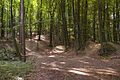
Behind Spürklenberg and Wenzelnberg

St. Reinoldi in the former Dückeburg hunting area


The Spürklenberg
At 111 meters above sea level, the Spürklenberg is only slightly lower than the Wenzelnberg . He is the middle of the three Immigrath-Wiescheider sand mountains. On its summit, its northwest flank and upstream to the northwest there are ramparts whose significance is unknown. The obvious solution would be to suspect remains of the opencast mine here. However, a connection with the murder of the imperial envoy in 973, which led to the abandonment of the founding of a monastery , was suspected .
In any case, on its northern flank is the forest cemetery , the only communal cemetery in Langenfeld and therefore open to the burial of people of all worldviews . On the western flank, toboggan runs for sled runs used to be marked.
The Kellerhansberg
The Kellerhansberg to the south is very rugged . A flat valley floor at 78.0 meters is bordered all around by connected elevations and plateaus of 92.5 - 92.6 and 93.4 meters. At a height of 90.0 meters, a ditch runs through the entire eastern flank of the mountain. In the middle of the valley floor is a conical, unmeasured mountain peak . On the eastern edge of the valley, a plateau halfway up also shows traces of human intervention. From the path past the Naturfreundehaus, called Am Block , there is access to the valley. This access is bordered by three elevations, which are indicated in the north-south direction in the official map 1: 5000 (Langenfeld-Hardt) with 6, 3 and 8 meters above the valley floor. To assume the remains of an open-cast mine here seems even more absurd than on the Spürklenberg . However, archaeological investigations of the entire area are pending. A connection with the founding of the monastery is also seen here, but without scientific evidence it is pure speculation .
Individual evidence
- ↑ a b c Stefanie Jooß: Created by the sea . (No longer available online.) December 2, 2008, formerly in the original ; Retrieved August 19, 2009 . ( Page no longer available , search in web archives ) Info: The link was automatically marked as defective. Please check the link according to the instructions and then remove this notice.
- ^ A b c d e f Rolf Müller: " Stadtgeschichte Langenfeld Rheinland ", Verlag Stadtarchiv Langenfeld 1992
- ^ Karl Siegmar von Galéra: " Langenfeld - From the Margraviate to the City ", oven, Langenfeld 1963
- ↑ a b ritter-pitter.de ( Memento from April 11, 2010 in the Internet Archive ), accessed on August 16, 2009.
Coordinates: 51 ° 6 ′ 50 ″ N , 6 ° 59 ′ 40 ″ E