
Rodau (Main)
| Rodau | ||
 Course of the Rodau |
||
| Data | ||
| Water code | DE : 24792 | |
| location | Hessen , Germany | |
| River system | Rhine | |
| Drain over | Main → Rhine → North Sea | |
| source | in a wooded headwaters west of Rödermark-Urberach 49 ° 58 ′ 11 ″ N , 8 ° 46 ′ 2 ″ E |
|
| muzzle | near Mühlheim in the Main Coordinates: 50 ° 7 '52 " N , 8 ° 49' 38" E 50 ° 7 '52 " N , 8 ° 49' 38" E
|
|
| length | 27.6 km | |
| Catchment area | 163.89 km² | |
| Discharge at the Mühlheim an der Muzzle gauge (99.98% of the catchment area) A Eo : 163.86 km² |
MNQ MQ Mq |
188 l / s 628 l / s 3.8 l / (s km²) |
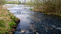
 The Rodau shortly before it flows into the Main |
||
The Rodau is a 28 km long stream in the Offenbach district in southern Hesse . It is a left and south tributary of the Main and a body of water of the type flowing water of the lowlands .
geography
course
The Rodau arises in a wooded headwaters southwest of Rödermark-Urberach . On the outskirts, it is reinforced by a spring called Rodauquelle (Lage) . Since the source area gives off little water in hot summers, a permanent water-bearing point has been enclosed in its young run on the outskirts of Urberach and called the Rodau spring . The Rodau flows through Urberach and Ober-Roden , all five districts of the city of Rodgau , the district area of Obertshausen and the village of Lämmerspiel .
At Mühlheim the Bieber (also called Bieberbach) flows into the Rodau, which in turn flows a few hundred meters further into the Main.
Tributaries
- Bach from the Langenwiese (right)
- Hörnersgraben (left)
- Schwarzbach (Bach von der Fasanerie) (right)
- Bauerbach (left)
- Pear tree ditch (right)
- Beaver (left)
Historical meaning

Finds from the Neolithic in Nieder-Roden have proven that the area on the Rodau was settled early. Grave finds from the Bronze Age near the Rodau complete the sparse settlement picture. In the further course of history, the dense forests of the Rodgau were cleared more and more, which could have given the area its name. The 19th century historian Johann Wilhelm Christian Steiner, however, was of the opinion that the name of Rodau (in medieval sources Rotaha ) originated from the color red. In the vicinity of the source, the stream would turn red in rainy weather. In fact, there are lawn iron ore deposits in the Urberacher Rodau spring that wash out red in heavy rain. In all old maps the Rodau first appears under the names Roda , Rodabach or Roda-Fluss , later also Rothenbach (1730), Roth (1755) or Rodt , which underpins Steiner's theory of origin. The name Rodau appears in documents and on maps only at the end of the 18th century.
The first documented settlement on the Rodau dates from February 25, 786 , according to the Lorsch Codex. In the document cited there, the Rotaha Monastery (Monastery on the Red Water) is mentioned in connection with a donation to the Lorsch Monastery . The exact location of Rotahas is not specified, but is assumed to be in Nieder-Roden or Ober-Roden on the basis of old field names.

Located directly on the Rodau, a moated castle owned by the von Hagenhausen family was mentioned in a document as Haginhusen in 1108 . Remnants of this castle are still slumbering under a meadow near the Rodau on today's Burgstrasse from Hainhausen . The Hagenhausen family, who, after moving to the Taunus as " Eppsteiner ", wrote a piece of German history in the Middle Ages, gained great importance and power from the 13th century .
On August 25, 1799 there was a skirmish between French soldiers and Rodgau farmers who belonged to the Kurmainzer Landsturm in the Rodau lowlands near the Tannenmühle (Weiskirchen district) in the course of the Second Coalition War against Napoleonic France . The fighting, known as Afaire an der Dannenmühl , ended in favor of the French. On July 9 and 10, 1800, Mainz Hussars fought again with the French cavalry at the Tannenmühle .
Buildings
Mills
Originally there were 21 water mills on the course of the Rodau , six of which still exist as buildings and one of them is run as a museum mill in Mühlheim.
The following mills were operated on the Rodau:
Roedermark
- Obermühle (Urberach) (~ 1475–1966)
- Untermühle (Urberach) (~ 1475–1951)
- Hanauer Mühle (Ober-Roden) (~ 1445- ~ 1632)
- Mainzer Mühle (also Maneval'sche Mühle) (Ober-Roden) (1569– ~ 1935)
Rodgau
- Wintermühle (also Heidmühle) (Jügesheim) (1742–1909?)
- Dorfmühle (Hainhausen) (<1551–1868)
- Obermühle (Weiskirchen) (<1397–1933)
- Bridge mill (Weiskirchen) (<1473– ~ 1846)
- Meckelsmühle (Weiskirchen) (<1576–1968), building exists as a residential building
- Grabenmühle (Weiskirchen) (<1576– ~ 1873)
- Tannenmühle (Weiskirchen) (<1495–1928), building exists as a restaurant
Obertshausen
- Obermühle (today YMOS) (?)
- Untermühle (? -1956?), Existing building, furnishings preserved
Muhlheim

- Dorfmühle (Lammerspiel) (<1490–1914)
- Hildebrandsmühle (also Weißkopfsmühle) (Mühlheim) (1576–1896)
- Street mill (also Reutermühle) (Mühlheim) (<1550– ~ 1907)
- Bridge mill (Mühlheim) (1576–1896), building exists as an operational museum mill
- Dorfmühle (Mühlheim) (<1490–1894), building exists as a residential building
- Lindenmühle (Mühlheim) (1352–1924), building exists as a residential building
- Kretzermühle (Mühlheim) (1497– ~ 1896)
- Mainmühle (Mühlheim) (1717– ~ 1780)
bridges
- Napoleon Bridge (near Tannenmühle, Weiskirchen) (1810)
- Rodaubrücke (Weiskirchen Bahnhofstrasse) (1853)
- Castle Bridge (Hainhausen Burgstrasse) (1872)
Sewage treatment plants
On the Rodau, between Ober-Roden and Nieder-Roden, the group sewage treatment plant of the city of Rödermark and between Weiskirchen and Obertshausen, the sewage treatment plant of the city of Rodgau.
Bach corrections

In the years 1938 and 1939, the Rodau was straightened and lowered over long distances by prisoners from the Rollwald camp . In the 1960s, it was piped in individual places and, in the case of the town house built in Nieder-Roden, even built over. In addition, several barriers were disabled. As a result, on August 19, 1981 a 24-hour continuous rain caused extensive flooding in the Rodgau area, especially in Nieder-Roden, with high levels of property damage.
In the 1990s the dismantled weirs were renewed as flood protection and in 2003 the renaturation of the Rodau lower reaches began. Today the Rodau winds between Rodgau-Weiskirchen and Mühlheim am Main again in its "old" stream bed. Species diversity has increased since the renaturation. Instead of only five, ten fish species have now been observed: among others gudgeon , three-spined stickleback , loach , chub , hazel and gable . In particular, the “water-land interlocking” and the “underwater landscape” have been improved. Near-natural riparian vegetation begins to develop on the banks.
Nevertheless, the Hessian State Office for Nature Conservation, Environment and Geology in Wiesbaden, together with the Bieber, classified the Rodau as one of the “most heavily polluted bodies of water in Hesse”. The stream has an extremely high proportion of clarified water. The water quality class would correspond to level III to IV (very heavily polluted). It is less about the actual quality of the water, but about the ratio of natural stream water to clarified water. The state office therefore recommends not to bathe in the stream. According to the State Office, small crabs or small snails are only found in limited numbers in Rodau. The living conditions are also rather unfavorable for diatoms .
Biking and hiking trails
From Weiskirchen to the confluence with the Main, the Rodauweg, part of the Rhine-Main Regional Park project, runs along the Rodau, as does the Mühlenwanderweg from Obertshausen via Lämmerspiel to Mühlheim.
Picture gallery

The headwaters near Rödermark-Urberach

so-called Rodau spring in Rödermark-Urberach

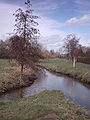
Flood plain on the Rodau
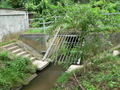
Piping of the Rodau in Nieder-Roden with floating debris retention

The renatured Rodau near Rodgau-Weiskirchen

Water place on Rodauweg near Obertshausen
The Bieber flows into the Rodau near Mühlheim
Rodau confluence with the Main in Mühlheim


See also
literature
- Gisela Rathert u. a .: Nieder-Roden - 786–1986. Nieder-Roden 1986.
- Margarete Zilch, Arnold Haag: Mills on the middle Rodau. Weiskirchen 2008.
Web links
- Level at Nieder-Roden on the HLUG side
- Hessian State Office for Nature Conservation, Environment and Geology: Retention Register of the Rodau River Area (PDF; 0.3 MB)
- Profile Rodau ( Memento from October 25, 2014 in the web archive archive.today )
Individual evidence
- ↑ Water map service of the Hessian Ministry for the Environment, Climate Protection, Agriculture and Consumer Protection ( information )
- ↑ Hessian State Office for Environment and Geology: Aquatic Area Directory 1: 25000 , accessed via hessenviewer on October 2, 2013
- ↑ WFD Hesse: Profile of Rodau surface water body
- ^ See Johann Wilhelm Christian Steiner: History and antiquities of the Rodgau in old Maingau , 1833, p. 28 ( Google books )
- ↑ Margarete Zilch and Arnold Haag: Mühlen an der Mittel Rodau , Weiskirchen 2008, page 25
- ↑ Glöckner, Karl, Codex Laureshamensis: Volume 1 - Introduction Regesten Chronik (1929), UrkNr. 12 (Reg. 1952), "Donatio Abe abbatisse de Rotaha monasterio, et aliis locis"
- ↑ Margarete Zilch and Arnold Haag: Mühlen an der Mittel Rodau , Weiskirchen 2008, page 156
- ↑ http://www.op-online.de/nachrichten/roedermark/buch-ueber-muehlen-638076.html Offenbach-Post February 20, 2010, Mühlen in Rödermark
- ↑ Margarete Zilch and Arnold Haag: Mills on the middle Rodau . Weiskirchen 2008, pages 48–168
- ↑ Margarete Zilch and Arnold Haag: Mills on the middle Rodau . Weiskirchen 2008, page 203
- ↑ http://www.muehlheim.de/images/pressestelle/wanderwegblau.pdf Mills in Lämmerspiel and Mühlheim
- ↑ http://www.op-online.de/nachrichten/muehlheim/extrem-hoch-RLetet-423368.html op-online.de: "Extremely high loaded"