
Rosenstein (mountain)
| Rosenstein | ||
|---|---|---|
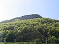
 Aerial view of Rosenstein from the southeast |
||
| height | 735.4 m above sea level NHN | |
| location | Baden-Wuerttemberg , Germany | |
| Mountains | Swabian Alb | |
| Coordinates | 48 ° 47 '47 " N , 9 ° 57' 37" E | |
|
||
| rock | White Jura | |


The Rosenstein is 735.4 m above sea level. NHN high mountain in the Swabian Alb above Heubach in the Ostalb district in Baden-Württemberg .
Recreation
The Rosenstein is a very popular local recreation area. On the saddle between the Glasenberg (telecommunications tower) and the actual Rosenstein there is a parking lot for hikers that can be reached by car from Heubach. At the west summit above the ruin there is a restaurant with a playground and barbecue facilities.
The Rosenstein has numerous vantage points over the lower northern land. In addition to the ruins in the west and the Sedelfelsen in the east, the noise rock protruding to the north offers an exposed vantage point with an orientation table above the ruins. When the view is clear, the view extends from here over the Stuttgart television tower to the northern Black Forest .
The Heubach telecommunications tower has a viewing platform that is occasionally open to the public.
Natural space
The many caves of the Rosenstein are also known, such as the Große Scheuer, the Dreieingangshöhle, the Pliksburggrotten, the Dampfloch, the Fuchsloch, the Haus, the Sandburrenschacht and the Finstere Loch . Most of these caves are freely accessible, at least in summer. In total, over 40 caves are known on the Rosenstein.
The eastern side of the Rosenstein was designated as a Rosenstein nature reserve by ordinance of the Stuttgart Regional Council of January 30, 1981 with the protected area number 1086 . The area has an area of 22.0 hectares. The protection purpose is the preservation and promotion of the plant and animal communities occurring there as well as the creation of a regeneration area for particularly threatened animal species.
history
Due to its exposed location as a protrusion of the Albtraufs , the Rosenstein has always had great strategic importance, which is impressively demonstrated by the history of the settlement. Tool finds in the caves on the Rosenstein date back to the Paleolithic Age . The place of discovery is the Kleine Scheuer , a cave on the southwestern edge of the rose stone, where artefacts from the Magdalenian and Aurignacian were found during excavations in the 20th century . During the pre-Roman Iron Age, a fortification was built on the Rosenstein massif, of which the remains of four ramparts, some from Celtic times, are still visible. It has been the subject of archaeological research since 2016.
The remains of a medieval castle, the Rosenstein castle ruins, stand above the Westfels .
Sports
For climbers , the Rosenstein is of national importance due to its up to forty meter high rock faces. For hikers, the Rosenstein is located on the Swabian Alb North Edge Path , the main hiking trail 1 of the Swabian Alb Association .
At the same time the Rosenstein is a popular area for mountain bike riders . Every year a race of the Mountain Bike Bundesliga takes place on the southwest side .
The city of Heubach organizes the mountain bike festival " Bike the Rock " on Rosenstein .
archaeological trail Rosenstein

In June 2018 the "Archaeopfad Rosenstein" was inaugurated. This approximately six-kilometer educational trail begins at the hiking car park on the Rosenstein. With display boards at eleven stations, it provides information about 15,000 years of settlement history on the Rosenstein, from the Stone Age through the Metal Age to the Middle Ages . The "Waldschenke Rosenstein" is located between stations 7 and 8.
| No. | station | image |
| 1 | Ramparts A and B |
|
| 2 | Wall system D |
|
| 3 | Dark hole |
|
| 4th | Great chafing |
|
| 5 | House |
|
| 6th | Celtic hill settlements |
|
| 7th | Wall system C |
|
| 8th | Lärmfels with a view of the Stone Age site "Sand" |
|
| 9 | Rosenstein castle ruins |
|
| 10 | Small barn |
|
| 11 | Three-entrance cave |
|
gallery

"Finsteres Loch" cave

"Great barn" cave

Cave "house"
East side of the rose stone: Sedelfelsen

Rosenstein ruins and the town of Heubach

Without leaves, you can see the spur location with the natural neck ditch of the Rosenstein ruin in winter

Telecommunication tower Heubach


Individual evidence
- ↑ Map services of the Federal Agency for Nature Conservation ( information )
- ↑ albtips.de, accessed on August 5, 2014
- ↑ accessed on July 28, 2018 ( page no longer available , search in web archives ) Info: The link was automatically marked as defective. Please check the link according to the instructions and then remove this notice.
- ↑ David Wagner: Experience the Rosenstein in a completely new way. in: Schwäbische Post from June 1, 2018.
Web links
- Profile of the nature reserve in the LUBW's list of protected areas
- Bergsucht.de - Climbing am Rosenstein ( Memento from February 20, 2012 in the Internet Archive )
- Virtual 360 ° bird's eye view from the television tower on the Glasenberg over the Rosenstein (alb360.de)
- Virtual 360 ° interior view of the Finsteren Loch (alb360.de)