Rudolfstein (Fichtel Mountains)
| Rudolfstein | ||
|---|---|---|
|
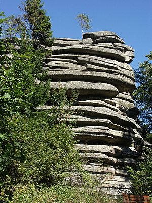
Typical rock formation on Rudolfstein |
||
| height | 866 m above sea level NN | |
| location | Bavaria , Germany | |
| Mountains | Fichtel Mountains | |
| Coordinates | 50 ° 4 '19 " N , 11 ° 52' 36" E | |
|
|
||
The Rudolfstein is a wooded mountain in the northeastern Schneeberg massif of the Fichtelgebirge , south of Weißenstadt . It is located on the Höhenweg at 866 m above sea level. NN . In the summit area there are several rock formations made of tin granite , layered by wool sack weathering , which form a protected natural monument. A staircase has been leading to the highest rock tower since 1890. Embedded in the rock formation there was a small castle ( Burgstall Rudolfstein ), which has disappeared almost without a trace.
The Rudolfstein is a popular hiking destination in spring and autumn because of its hardwood population. Starting points for hikes are Weißenstadt ( Höhenweg ) and the districts of Meierhof or Schönlind (Blaupunktweg). At the summit you have a beautiful view of the Weißenstädter See .
history
In the year 857, Count Palatine Rudolf, from whom the mountain got its name, is said to have built the first fortifications in the Nordgau , which is not documented. On the northern slope there was once brisk tin mining.
The first documentary mention of a castle, the "Rudolfstein Castle", comes from the year 1317, when Count Berthold von Henneberg received the castle and the associated places including Weißenkirchen (Weißenstadt) as an imperial fief (see also: Henneberg fiefdom directory ). He enfeoffed the brothers Heinrich, Friedrich, Arnold, Eberhard and Haymann von Hirschberg with the goods. The Hirschbergers allowed themselves to be carried away to attack the neighboring areas of the Waldsassen monastery , which is said to have resulted in the storming and destruction of the castle. On January 22nd, 1333 the Hirschbergers announced that they had got their goods back and that they were officials of Rudolfstein and Weißenstadt. In 1347 the burgraves of Nuremberg acquired the Rudolfstein and the associated goods. When the castle was actually destroyed cannot be clearly proven, after 1485 it is no longer mentioned in the files. During the War of the Spanish Succession in 1703, when Margrave Christian Ernst von Bayreuth and the Kaiser marched against Bavaria, a guard with a noise fire was set up on the Rudolfstein . The cartographer Johann Christoph Stierlein completed a very precise map of the Rudolfsstein for the first time in 1816 with the traces of a castle that still existed.
Geotope
The Rudolfstein summit has been designated as a valuable geotope (geotope number: 479R021) and a natural monument by the Bavarian State Office for the Environment .
literature
- Johann Theodor Benjamin Helfrecht : Ruins, antiquities and still standing castles on and on the Fichtel Mountains . Court 1795.
- Dietmar Herrmann, Helmut Süssmann: Fichtel Mountains, Bavarian Vogtland, Steinwald, Bayreuther Land. Lexicon . Ackermannverlag, Hof (Saale) 2000, ISBN 3-929364-18-2 .
- Bernhard Hermann Röttger : District of Wunsiedel and urban district of Marktredwitz . The Art Monuments of Bavaria , VIII. Administrative Region Upper Franconia, Volume 1 . Munich 1954. ISBN 3-486-41941-2 . Pp. 248-250.
- Hans Vollet and Kathrin Heckel: The ruins drawings by the Plassenburg cartographer Johann Christoph Stierlein . 1987.
Individual evidence
- ↑ Rudolfstein at bayern-fichtelgebirge.de
- ^ Rudolfstein Summit SE von Schönlind in the Bavarian Environmental Atlas, Bavarian State Office for the Environment (accessed on June 1, 2019).

