Ruprechtický Špičák
| Ruprechtický Špičák | ||
|---|---|---|
|
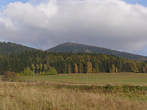
View from Vižňov to Ruprechtický Špičák |
||
| height | 880.5 m nm | |
| location | Czech Republic | |
| Mountains | Broumovská vrchovina | |
| Coordinates | 50 ° 39 ′ 41 ″ N , 16 ° 16 ′ 53 ″ E | |
|
|
||
| rock | Ignimbrite , rhyolite , rhyolite tuff | |
| Development | Observation tower | |
| particularities | highest mountain in the Heidelgebirge | |
The Ruprechtický Špičák (German Ruppersdorfer Spitzberg , Polish Ruprechticki Szpiczak ) is a wooded mountain in the north of the Broumovská vrchovina ( Braunauer Bergland ) in Okres Náchod in the Czech Republic . Its summit is five kilometers northeast of Meziměstí , and the state border with Poland runs 40 m east . The Ruprechtický Špičák, which is mostly covered with spruce forest, is the highest point in the Heidelberg Mountains ( Javoří hory )
geography
The Ruprechtický Špičák is part of the mountain range of the Heidelgebirge ( Javoří hory ) which forms the border between the Czech Republic and Poland and which merges into the Dürre Mountains ( Góry Suche ) to the north on Polish territory . The Broumovská kotlina ( Braunau Basin ), through which the Stěnava ( stones ) flow, extends to the south . The Ruprechtický potok ( Ruppersdorfer Wasser ), which rises north-west of the mountain in the water bed ( Vodní strž ), drains south to the Stěnava. North of the mountain is the source of the Złota Woda ( Goldwasser ), a tributary to the Bystrzyca ( Weistritz ). The Sokołowiec Mały ( Kleiner Freudengraben ) rises one and a half kilometers to the northwest , and its water flows northwest through the Büttnergrund into the Sokołowiec ( Freudengraben ). The yellow marked hiking trail leads from Meziměstí and the blue marked trail from Ruprechtice up the mountain.
To the north rise the Waligóra ( Heidelberg , 933 m npm), the Reimswaldauer Riegel (834 m npm) and the Granicznik ( Grenzberg , 801 m npm), to the east the Široký vrch ( wide mountain , 840 m nm), to the west the Světlina ( Lichtenhauberg) , 796 m nm) and to the northwest the Kopica ( Kesselkoppe , 797 m nm), the Garniec ( Schüsselberg , 763 m npm), the Scholzenköppel (785 m npm) and the Czarnek ( Schwarzer Berg , 868 m nm).
Surrounding villages are Trzy Strugi ( Dreiwässertal ) and Radosno ( Freudenburg ) in the northeast, Heřmánkovice ( Hermsdorf ) in the southeast, Hynčice ( Heinzendorf ) and Ruprechtice ( Ruppersdorf ) in the south, Vižňov ( meadows ) and Pomeznice ( border villages ) in the southwest, Lesní Domky ( Bushhouses ) in the west and Bednarski Jar ( Büttnergrund ) and Sokołowsko ( Görbersdorf ) in the northwest.
history
Several trade routes between Bohemia and the Glatzer Land used to lead around the Spitzberg . The Glashüttensteig ran from Ruppersdorf to Freudenburg over the pass between the Spitzberg and Breiten Berg. Another path led from Ruppersdorf through the bottom of the water over the pass between Spitzberg and Kesselkoppe, where it crossed the Hohe Straße, which ran from Wüstegiersdorf to Görbersdorf or Wiesen, to Reimswaldau .
Observation tower
After the tourist border crossing Ruprechtický Špičák - Łomnica was opened east of the summit on the old Glashüttensteig in the 1990s , the Broumov Forestry Department developed plans in 1999 to build a wooden lookout tower on Ruprechtický Špičák, as the dominant but wooded summit has little view granted. Due to a lack of funds, the time for implementation was open. At the same time, Český Mobil as ran a location search for a mobile radio station. Both projects were quickly merged.
In 2000, Český Mobil as began building a steel transmission tower on Ruprechtický Špičák, which could also be used as a freely accessible observation tower. In doing so, Český Mobil relied largely on the construction documents of a transmission and observation tower previously built on the Val in the Hannsdorfer Bergland . The 30 m high tower was opened on September 1st, 2002.
From the viewing platform at a height of 22 m there is a panoramic view over the Braunau basin to the Falkengebirge , the Großer Heuscheuer , the Ostaš , the Adlergebirge , the Turov and the Adršpach-Weckelsdorf rock town , as well as to the Rabengebirge , Rehorngebirge , Giant Mountains and Dürre Mountains .


