Soernewitz (Coswig)
|
Soernewitz
Large district town of Coswig
Coordinates: 51 ° 8 ′ 13 ″ N , 13 ° 31 ′ 13 ″ E
|
|
|---|---|
| Height : | 105 m above sea level NN |
| Incorporation : | July 1, 1950 |
| Postal code : | 01640 |
| Area code : | 03523 |

Sörnewitz is a district of Coswig in the Saxon district of Meißen . In the district Sörnewitz is also the district Coswiger Neusörnewitz .
geography
Sörnewitz is located in the far west of the Coswig urban area. The Sörnewitz district includes the Sörnewitz district and the western part of the Neusörnewitz district . The district of Sörnewitz is surrounded by the other Coswig districts of Brockwitz in the southeast and Neusörnewitz in the northeast. The city of Meissen ( Oberspaar district ) borders to the north and west , and the municipality of Klipphausen with the village of Scharfenberg to the south . The Sörnewitz district, on the other hand, borders on the Clieben district in the east, the Brockwitz district in the east, Weinböhla in the far northeast , the Zaschendorf district in the north and the Oberspaar district in the west. Scharfenberg lies to the south.
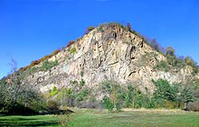
The village of Sörnewitz is located on the banks of the Elbe in the north-western part of the Elbe valley . The foothills of the Spaar Mountains, which are considered to be the smallest mountain range in Saxony, begin immediately to the west of the village center . In the Sörnewitz area there is the Deutsche Bosel with the distinctive Boselspitze (183 m above sea level) and to the north of it the Roman Bosel. In the south of the corridor, the village center has been preserved in the form of a street village with the two and three-sided courtyards and a four-sided courtyard typical of the area. In the latter there is a restaurant and a historic pigeon house on two pillars from 1845. To the north of the village center are areas used for agriculture and horticulture in Nassau , where wine is grown on the Bosel. In Sörnewitz the Lockwitzbach coming from Moritzburg flows into the Elbe.
history
Sörnewitz was first mentioned in a document in 1205, when Margrave Dietrich the Oppressed donated the village “Sornuitz” and its neighboring towns to the Augustinian Canons Monastery of St. Afra in Meißen. The place name comes from the Old Sorbian "Zornowica" and means " mill place ". Over the centuries it changed, among other things, to the current name via the forms "surnewytcz", "sarnewitz" and "sornewicz".
Bronze Age finds and settlement remains on the Bosel prove the early presence of people in the area. In Slavic times there was probably a sanctuary on the Bosel - the name of the mountain is derived from the Slavic word for "God" (cf. Czorneboh ). On the 418 hectare (as of 1900) Sörnewitz Gewannflur , the residents mainly farmed and raised livestock, and viticulture was added later on the slopes of the Spaar Mountains.
In the time of the Margraviate of Meißen , Sörnewitz was initially administered by the Hayn Office , and in 1625 this task was transferred to the Moritzburg Office . The basic rule practiced in 1547 proportionally the office itself, the Hospital Meissen and the parish Frauenhain out. Sörnewitz later became an official village and in 1764 was subordinate to the Meissen Abbey . From 1875 it belonged to the administrative authority of Meißen . Sörnewitz was and is a parish to Brockwitz. The Sörnewitzer Heeger, an Elbe island, was located below the village until the 19th century . Due to the flooding of the Elbe in 1845 , Sörnewitz with the Spaargebirge and several districts on the right Elbe was on a large island for several days. A passenger ferry has operated between Sörnewitz and Scharfenberg since the 19th century.
Sörnewitz introduced his first own seal in 1779. It shows three flowers of the corn wheel rising from water and reeds . On the basis of the rural community code of 1838 , Sörnewitz became an independent rural community . In the course of industrialization, the area of Neusörnewitz developed in the north. On July 1, 1950, the municipality of Sörnewitz was incorporated into Coswig.
Population development
|
Personalities
- Annemarie Dose (1928–2016), founder of the Hamburger Tafel
- Hans-Ulrich Thomale (* 1944), former German soccer player and coach, began his career at Motor Sörnewitz
Web links
- Sörnewitz (Coswig) in the Digital Historical Directory of Saxony
- Kultur- und Heimatverein Sörnewitz e. V.
- Sörnewitz at www.historisches-coswig.de
- History of the Elbe ferry Sörnewitz
- Friends of the Alter Gasthof Sörnewitz e. V.


