South Sandwich Islands
| South Sandwich Islands | |
|---|---|
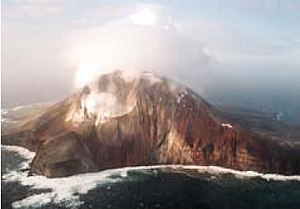
| Zavodovski Island, the northernmost island | |
| Waters | South Atlantic |
| Geographical location | 57 ° 45 ′ S , 26 ° 30 ′ W |
| Number of islands | 11 without secondary islands |
| Main island | Montagu Island |
| Total land area | 310 km² |
| Residents | uninhabited |
| Map of South Georgia and the South Sandwich Islands | |
The South Sandwich Islands are a chain of islands in the sub-Antarctic South Atlantic . Politically, the group belongs to the British overseas territory of South Georgia and the South Sandwich Islands , but is also claimed by Argentina . Due to their geographical location, the South Sandwich Islands are not subject to the Antarctic Treaty and therefore not subject to the status quo regulation of Article 4 of the Treaty.
geography
overview
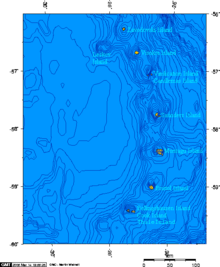
The South Sandwich Islands are located within the South Atlantic in a southeast direction from South Georgia . They extend as an island arc on the northeast and eastern edge of the sandwich plate , which in the region of the island chain in the northeast and east meets the South American plate , where the south sandwich trench is located. South of the chain of islands, the first-mentioned plate meets the Antarctic plate .
Almost all of the South Sandwich Islands are of volcanic origin . Some of them still have active volcanoes, such as Mount Belinda (1370 m) on Montagu Island , which has been active for several years . Because of their sub-Antarctic location and volcanic landscape, the islands are uninhabited. However, they are home to a large number of seabirds and seal colonies.
From 1976 to 1982, the permanently manned Argentine research station Corbeta Uruguay was on Morrell Island . In January 1955, Argentina built the Refugio Teniente Esquivel summer station at the same location, but had to be abandoned a year later due to a volcanic eruption. There and on Zavodovski Island today only automatic (unmanned) weather stations are available.
About 65 kilometers northwest of Zavadovski is the submarine volcano Protector Shoal , at position 55 ° 54 ′ S , 28 ° 6 ′ W , with a shallowest depth of 27 meters below sea level. The last outbreak occurred in 1962.
About 40 kilometers southwest of Thule Island is the Vysokaya Bank on position 59 ° 43 ' S , 27 ° 58' W . This has a shallowest depth of 84 meters.
The islands
![]() Map with all coordinates: OSM | WikiMap
The following table lists the South Sandwich Islands from north to south:
Map with all coordinates: OSM | WikiMap
The following table lists the South Sandwich Islands from north to south:
| Island ( Spanish name ) | Area (km²) |
Highest elevation | (m) | Coordinates | ||||
| Traversay Islands | ||||||||
| Zavodovski Island | 25th | Mount Curry | 550 | 56 ° 18 ′ S , 27 ° 35 ′ W | ||||
| Leskov Island | 0.36 | Rudder Point | 190 | 56 ° 40 ′ S , 28 ° 6 ′ W | ||||
| Visokoi Island | 35 | Mount Hodson | 915 | 56 ° 42 ′ S , 27 ° 12 ′ W | ||||
| Candlemas Islands (sometimes included in the Traversay Islands) | ||||||||
| Candlemas ( Candelaria ) | 14th | Mount Andromeda | 550 | 57 ° 6 ′ S , 26 ° 43 ′ W | ||||
| Vindication ( Vindicación ) | 5 | Quadrant Peak | 430 | 57 ° 7 ′ S , 26 ° 49 ′ W | ||||
| Centrally located islands | ||||||||
| Saunders Island | 40 | Mount Michael | 990 | 57 ° 48 ′ S , 26 ° 29 ′ W | ||||
| Montagu Island ( Jorge ) | 110 | Mount Belinda | 1370 | 58 ° 27 ′ S , 26 ° 22 ′ W | ||||
| Bristol Island ( Blanca ) 1) | 46 | Mount Darnley | 1100 | 59 ° 1 ′ S , 26 ° 32 ′ W. | ||||
| Southern Thule Islands | ||||||||
| Bellingshausen | 2 | Basilisk Peak | 255 | 59 ° 25 ′ S , 27 ° 5 ′ W | ||||
| Cook Island | 20th | Mount Harmer | 1115 | 59 ° 26 ′ S , 27 ° 11 ′ W | ||||
| Morrell Island ( Tule del Sur ) 2) | 14th | Mount Larsen | 710 | 59 ° 26 ′ S , 27 ° 22 ′ W | ||||
| South Sandwich Islands | 310 | Mount Belinda | 1370 | |||||
1) with three offshore islands to the west :
- Grindle Rock (0.30 km²)
- Wilson Rock
- Freezland Rock (0.32 km²)
2) with the secondary island Twitcher Rock (0.01 km²)
history
The three northernmost islands ( Traversay Islands ) were discovered in 1819 by the Russian navigator Fabian Gottlieb von Bellingshausen . Years before, around 1775, the British navigator James Cook had discovered the southern islands. The name of the entire island chain can be traced back to the English naval admiral John Montagu , the fourth Earl of Sandwich (1718–1792). The addition Southern was necessary because James Cook discovered what is now Hawaii in 1778 , the islands of which he also called the Sandwich Islands at the time .
See also
literature
- S James Clark Ross JR206 Cruise Report: Volcanic and Continental Slope Processes, South Georgia and South Sandwich Islands. PT Leat, AJ Tate, TJ Deen, SJ Day & MJ Owen: British Antarctic Survey Cruise Report: Falkland Islands - South Georgia - South Sandwich Islands - Halley - Montevideo. Report of RRS James Clark Ross cruise JR206, January-March 2010
- Patrick G. Quilty: Origin and Evolution of the Sub-Antarctic Islands: The Foundation. Papers and Proceedings of the Royal Society of Tasmania, Volume 141 (1), 2007, pp. 35–58 (PDF; 1.3 MB)
Web links
- Aviation chart , 1: 1 000 000 ( ONC chart , sheet U-19)
- Argentine nautical map of the South Sandwich Islands
- Natural Environment Research Council: Bathymetry and Geological Setting of the South Sandwich Islands Volcanic Arc. Side 2: The South Sandwich Islands, London 2014
Individual evidence
- ↑ http://www.histarmar.com.ar/Antartida/RefugioThule2-ElYeti.htm
- ↑ http://www.histarmar.com.ar/Antartida/RefugioThule1-.htm
- ↑ Argentine nautical chart with depth indication 84 meters southeast of Morrell. In Volume 124 of the Sailing Directions ( East Coast of South America ) this point is also described without a name: A bank, with a least charted depth of 84m, the position of which is approximate, lies about 28 miles SW of the W extremity of Thule Iceland.


