Saint-Etienne-de-Fursac
| Saint-Etienne-de-Fursac | ||
|---|---|---|
|
|
||
| local community | Fursac | |
| region | Nouvelle-Aquitaine | |
| Department | Creuse | |
| Arrondissement | Guéret | |
| Coordinates | 46 ° 9 ' N , 1 ° 31' E | |
| Post Code | 23290 | |
| Former INSEE code | 23192 | |
| Incorporation | January 1, 2017 | |
| status | Commune déléguée | |
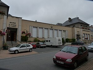
 The joint Mairie with Saint-Pierre-de-Fursac |
||
Saint-Étienne-de-Fursac is a village and a commune déléguée in the French commune of Fursac with 767 inhabitants (as of January 1, 2017). The residents call themselves Fursacois .
The municipality of Saint-Étienne-de-Fursac merged with Saint-Pierre-de-Fursac to form the new municipality of Fursac on January 1, 2017 . It belonged to the Nouvelle-Aquitaine region , the Creuse department , the Guéret arrondissement and the Le Grand-Bourg canton .
geography
Saint-Étienne-de-Fursac is located in the north-west of the Massif Central at 324 meters above sea level.
The municipality was bordered to the northwest by Saint-Pierre-de-Fursac , to the north by Saint-Priest-la-Feuille , to the northeast by Chamborand , to the east by Le Grand-Bourg , to the southeast by Marsac , to the south by Arrènes , to the southwest with Laurière and to the west with Folles .
Population development of the former municipality
| year | 1962 | 1968 | 1975 | 1982 | 1990 | 1999 | 2008 | 2012 |
|---|---|---|---|---|---|---|---|---|
| Residents | 1248 | 1084 | 882 | 904 | 843 | 816 | 849 | 811 |

