
Saint-Priest-la-Feuille
| Saint-Priest-la-Feuille | ||
|---|---|---|
|
||
| region | Nouvelle-Aquitaine | |
| Department | Creuse | |
| Arrondissement | Guéret | |
| Canton | La Souterraine | |
| Community association | Monts et Vallées Ouest Creuse | |
| Coordinates | 46 ° 12 ' N , 1 ° 32' E | |
| height | 328-456 m | |
| surface | 27.44 km 2 | |
| Residents | 771 (January 1, 2017) | |
| Population density | 28 inhabitants / km 2 | |
| Post Code | 23300 | |
| INSEE code | 23235 | |

Saint-Priest-la-Feuille is a municipality in France . It belongs to the Nouvelle-Aquitaine region , the Creuse department , the Guéret arrondissement and the Souterraine canton .
geography
The Via Lemovicensis , one of the four historical " Routes of the Pilgrims of St. James in France ", leads via Saint-Priest-la-Feuille. The neighboring communities are
- La Souterraine in the north-west and in the north,
- Lizières in the east,
- Le Grand-Bourg and Chamborand in the southeast,
- Fursac with Saint-Étienne-de-Fursac in the south and Saint-Pierre-de-Fursac in the southwest.
The Gartempe flows through the municipal marker .
Population development
| year | 1962 | 1968 | 1975 | 1982 | 1990 | 1999 | 2008 | 2013 |
|---|---|---|---|---|---|---|---|---|
| Residents | 901 | 790 | 689 | 638 | 635 | 619 | 695 | 812 |
Attractions
- Dolmen de la Pierre Folle
- Saint Laurent Church
- Menhir de la Rebeyrolle
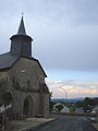
Saint Laurent Church

Menhir de la Rebeyrolle

Dolmen de la Pierre Folle

The Via Lemvicensis at Saint-Priest-la-Feuille
,_l%27%C3%A9glise.JPG)


,_sur_le_chemin_de_St.jacques.JPG)
Web links
Commons : Saint-Priest-la-Feuille - Collection of images, videos and audio files