
Saint-Goussaud
| Saint-Goussaud | ||
|---|---|---|
|
||
| region | Nouvelle-Aquitaine | |
| Department | Creuse | |
| Arrondissement | Guéret | |
| Canton | Le Grand-Bourg | |
| Community association | Monts et Vallées Ouest Creuse | |
| Coordinates | 46 ° 2 ′ N , 1 ° 35 ′ E | |
| height | 377-694 m | |
| surface | 24.3 km 2 | |
| Residents | 162 (January 1, 2017) | |
| Population density | 7 inhabitants / km 2 | |
| Post Code | 23430 | |
| INSEE code | 23200 | |

Saint-Goussaud is a French commune in the Creuse in the region Nouvelle-Aquitaine . It belongs to the arrondissement of Guéret and the canton of Le Grand-Bourg .
geography
It borders on Arrènes to the north, Châtelus-le-Marcheix to the east, Les Billanges to the south, Jabreilles-les-Bordes to the west and Laurière to the north-west . The settlement area consists of the villages of Bossabut, Champégaud, Le Châtain, La Châtenède, Le Crocq, La Feyte, Le Fieux, Friaulouse, Les Gabiauds, Lavaud, Millemilanges, Redondessagne, La Ribière, La Roche, Séjoux and La Verdenne. The highest point in the municipality is the mountain peak of the Puy de Jouer at 694 m . The origin of the village is Gallo-Roman .

Saint-Goussaud church from the 12th century, monument historique

Saint-Goussaud memorial, Monument historique
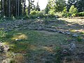
Remains of a Gallo-Roman theater, Monument historique

_lanterne_des_morts.JPG)

Population development
| year | 1962 | 1968 | 1975 | 1982 | 1990 | 1999 | 2008 | 2012 |
|---|---|---|---|---|---|---|---|---|
| Residents | 407 | 353 | 285 | 271 | 238 | 213 | 205 | 192 |