
Azerables
| Azerables | ||
|---|---|---|
|
||
| region | Nouvelle-Aquitaine | |
| Department | Creuse | |
| Arrondissement | Guéret | |
| Canton | Dun-le-Palestel | |
| Community association | Monts et Vallées Ouest Creuse | |
| Coordinates | 46 ° 21 ′ N , 1 ° 29 ′ E | |
| height | 273-394 m | |
| surface | 39.44 km 2 | |
| Residents | 815 (January 1, 2017) | |
| Population density | 21 inhabitants / km 2 | |
| Post Code | 23160 | |
| INSEE code | 23015 | |

Azerables , in Latin "Acer abulus", is a municipality in the Massif Central in France . It belongs to the Nouvelle-Aquitaine region , the Creuse department , the Guéret arrondissement and the Dun-le-Palestel canton . It is bordered by Les Grands-Chézeaux to the west, by Mouhet to the northwest , by Saint-Sébastien to the northeast, by Bazelat to the east, by Saint-Agnant-de-Versillat to the southeast, by Vareilles to the south and by Saint-Sulpice to the southwest . les-Feuilles . There are numerous small lakes in the municipality, including the Étang de la Chaume .
Population development
| year | 1962 | 1968 | 1975 | 1982 | 1990 | 1999 | 2008 | 2013 |
|---|---|---|---|---|---|---|---|---|
| Residents | 1297 | 1258 | 1136 | 1033 | 1019 | 958 | 890 | 868 |
Attractions
- Gothic chapel, Monument historique
- Saint-Georges church, also a monument historique
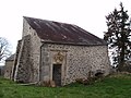
Gothic chapel

Saint-Georges church
.JPG)

Personalities
- Léonard-Léopold Forgemol de Bostquénard , General
Web links
Commons : Azerables - collection of images, videos and audio files