
Naillat
| Naillat | ||
|---|---|---|
|
||
| region | Nouvelle-Aquitaine | |
| Department | Creuse | |
| Arrondissement | Guéret | |
| Canton | Dun-le-Palestel | |
| Community association | Monts et Vallées Ouest Creuse | |
| Coordinates | 46 ° 16 ' N , 1 ° 38' E | |
| height | 316-530 m | |
| surface | 36.23 km 2 | |
| Residents | 639 (January 1, 2017) | |
| Population density | 18 inhabitants / km 2 | |
| Post Code | 23800 | |
| INSEE code | 23141 | |

Naillat is a municipality in the Massif Central in France . It belongs to the Nouvelle-Aquitaine region , the Creuse department , the Guéret arrondissement and the Dun-le-Palestel canton .
location
It borders in the north on Colondannes , Dun-le-Palestel and Saint-Sulpice-le-Dunois , in the east on Bussière-Dunoise , in the south on Fleurat and Saint-Priest-la-Plaine and in the west on Noth and Saint-Léger- Bridereix . The municipality is crossed by the Brézentine river.
Population development
| year | 1962 | 1968 | 1975 | 1982 | 1990 | 1999 | 2008 | 2013 |
|---|---|---|---|---|---|---|---|---|
| Residents | 1225 | 1084 | 955 | 809 | 721 | 641 | 657 | 680 |
Attractions
- Dolmen Pierre cubed
- Saint-Médard church from the 15th century

Dolmen Pierre cubed
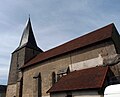
Saint-Médard church
.JPG)

Web links
Commons : Naillat - collection of images, videos and audio files