Saint-Avit-le-Pauvre
| Saint-Avit-le-Pauvre | ||
|---|---|---|
|
|
||
| region | Nouvelle-Aquitaine | |
| Department | Creuse | |
| Arrondissement | Guéret | |
| Canton | Ahun | |
| Community association | Creuse Sud Ouest | |
| Coordinates | 46 ° 0 ′ N , 2 ° 3 ′ E | |
| height | 529-618 m | |
| surface | 4.99 km 2 | |
| Residents | 78 (January 1, 2017) | |
| Population density | 16 inhabitants / km 2 | |
| Post Code | 23183 | |
| INSEE code | 23183 | |
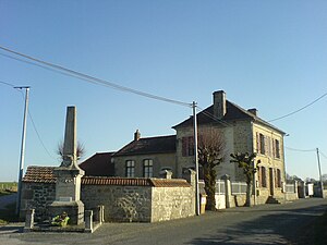
 Mairie and war memorial |
||
Saint-Avit-le-Pauvre is a commune in the Massif Central in France . It belongs to the Nouvelle-Aquitaine region , the Creuse department , the Guéret arrondissement and the Ahun canton .
geography
In addition to the main settlement, the hamlets of Montécudier, La Rebeyrette, Le Monteil and Combredet also belong to the municipality. The neighboring municipalities are Fransèches in the north, Ars in the east and Saint-Sulpice-les-Champs in the south and west.
Population development
| year | 1962 | 1968 | 1975 | 1982 | 1990 | 1999 | 2012 |
|---|---|---|---|---|---|---|---|
| Residents | 109 | 104 | 91 | 76 | 69 | 80 | 74 |
Attractions
- Saint Anthony Church
- War memorial
Web links
Commons : Saint-Avit-le-Pauvre - collection of images, videos and audio files

