
Saint-Sulpice-le-Dunois
| Saint-Sulpice-le-Dunois | ||
|---|---|---|
|
||
| region | Nouvelle-Aquitaine | |
| Department | Creuse | |
| Arrondissement | Guéret | |
| Canton | Dun-le-Palestel | |
| Community association | Monts et Vallées Ouest Creuse | |
| Coordinates | 46 ° 18 ′ N , 1 ° 44 ′ E | |
| height | 218-546 m | |
| surface | 30.85 km 2 | |
| Residents | 607 (January 1, 2017) | |
| Population density | 20 inhabitants / km 2 | |
| Post Code | 23800 | |
| INSEE code | 23244 | |

Saint-Sulpice-le-Dunois is a commune in the Massif Central in France . It belongs to the Nouvelle-Aquitaine region , the Creuse department , the Guéret arrondissement and the Dun-le-Palestel canton .
geography
Saint-Sulpice-le-Dunois is affected by the Creuse . In addition to the main settlement, the northern village of Champotier is also part of the municipality's mark. The neighboring municipalities are Villard in the north-west, La Celle-Dunoise in the north-east and east, Bussière-Dunoise in the south, Naillat in the south-west and Dun-le-Palestel in the west.
Attractions
- Saint Sulpice Church
- Chapel Saint-Jean in the district of Le Mas Saint-Jean at 473 meters above sea level

Remains of the former lavoir in the Champotier district
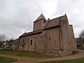
Saint Sulpice Church
_1.jpg)

Population development
| year | 1962 | 1968 | 1975 | 1982 | 1990 | 1999 | 2008 | 2013 |
|---|---|---|---|---|---|---|---|---|
| Residents | 965 | 913 | 795 | 750 | 698 | 634 | 638 | 650 |
Web links
Commons : Saint-Sulpice-le-Dunois - Collection of images, videos and audio files