
Saint-Yrieix-les-Bois
| Saint-Yrieix-les-Bois | ||
|---|---|---|
|
||
| region | Nouvelle-Aquitaine | |
| Department | Creuse | |
| Arrondissement | Guéret | |
| Canton | Ahun | |
| Community association | Grand Guéret | |
| Coordinates | 46 ° 6 ′ N , 1 ° 56 ′ E | |
| height | 417-645 m | |
| surface | 15.7 km 2 | |
| Residents | 286 (January 1, 2017) | |
| Population density | 18 inhabitants / km 2 | |
| Post Code | 23150 | |
| INSEE code | 23250 | |
 Town Hall ( Mairie ) |
||

Saint-Yrieix-les-Bois is a commune in the Massif Central in France . It belongs to the Nouvelle-Aquitaine region , the Creuse department , the Guéret arrondissement and the Ahun canton .
geography
It is bordered by La Saunière to the north, Mazeirat to the northeast, Saint-Hilaire-la-Plaine and Ahun to the east, Sous-Parsat to the south, Lépinas to the southwest and Peyrabout to the west . The settlement area consists of the villages of Beaumont, Bois-de-Chaumeix, Bois-Rousseau, Champrénier, La Charse, Chaumeix, Le Chezeau, Chierlat, Chiroux, L'Epeisse, La Faye, Massoux, Pierregrosse, Tigoulet and Villerégnier.
Population development
| year | 1962 | 1968 | 1975 | 1982 | 1990 | 1999 | 2008 | 2012 |
|---|---|---|---|---|---|---|---|---|
| Residents | 438 | 385 | 338 | 307 | 326 | 311 | 324 | 292 |
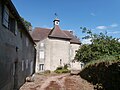
Château de Beaumont

Ruins of the Gallo-Roman fortress
.JPG)


Web links
Commons : Saint-Yrieix-les-Bois - Collection of images, videos and audio files