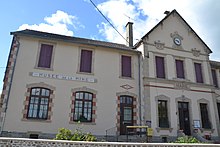
Bosmoreau-les-Mines
| Bosmoreau-les-Mines | ||
|---|---|---|
|
|
||
| region | Nouvelle-Aquitaine | |
| Department | Creuse | |
| Arrondissement | Guéret | |
| Canton | Bourganeuf | |
| Community association | Creuse Sud Ouest | |
| Coordinates | 46 ° 0 ′ N , 1 ° 45 ′ E | |
| height | 390-515 m | |
| surface | 9.01 km 2 | |
| Residents | 244 (January 1, 2017) | |
| Population density | 27 inhabitants / km 2 | |
| Post Code | 23400 | |
| INSEE code | 23027 | |
Bosmoreau-les-Mines , in Occitan "Bouo Mouré", is a municipality in the Massif Central in France . It belongs to the Nouvelle-Aquitaine region , the Creuse department , the Guéret arrondissement and the Bourganeuf canton . It borders in the north-west and north on Saint-Dizier-Masbaraud with Saint-Dizier-Leyrenne , in the east on Thauron and in the south and south-west on Masbaraud-Mérignat .
The Taurion forms the municipal boundary in the southeast.
Population development
| year | 1962 | 1968 | 1975 | 1982 | 1990 | 1999 | 2008 | 2016 |
|---|---|---|---|---|---|---|---|---|
| Residents | 414 | 444 | 377 | 301 | 249 | 272 | 249 | 249 |
Mining museum
The Musée de la Mine de Bosmoreau-les-Mines shows the 150-year history of hard coal mining .
Web links
Commons : Bosmoreau-les-Mines - Collection of images, videos and audio files

