
Saint-Agnant-de-Versillat
| Saint-Agnant-de-Versillat | ||
|---|---|---|
|
||
| region | Nouvelle-Aquitaine | |
| Department | Creuse | |
| Arrondissement | Guéret | |
| Canton | La Souterraine | |
| Community association | Monts et Vallées Ouest Creuse | |
| Coordinates | 46 ° 17 ′ N , 1 ° 31 ′ E | |
| height | 279-449 m | |
| surface | 50.46 km 2 | |
| Residents | 1,094 (January 1, 2017) | |
| Population density | 22 inhabitants / km 2 | |
| Post Code | 23300 | |
| INSEE code | 23177 | |

Saint-Agnant-de-Versillat is a municipality in the Massif Central in France . It belongs to the Nouvelle-Aquitaine region , the Creuse department , the Guéret arrondissement and the Souterraine canton . The residents call themselves Versillacois.
Geography and infrastructure
Saint-Agnant-de-Versillat is located on the Sedelle and borders Vareilles in the west, Azerables in the north-west, Bazelat in the north, Saint-Germain-Beaupré in the north-east, Saint-Léger-Bridereix in the east, Noth in the south-east and to the south at La Souterraine .
The Via Lemovicensis , one of the four historical " Paths of the Pilgrims of St. James in France ", leads via Saint-Agnant-de-Versillat.
The nearest train stations are in La Souterraine and Saint-Germain-Beaupré on the Saint-Sulpice-Laurière - Vierzon railway line .
history
Saint-Étienne-de-Versillat was an independent municipality until 1825 and was then incorporated into Saint-Germain-Beaupré and Saint-Agnant-de-Versillat.
Population development
| year | 1962 | 1968 | 1975 | 1982 | 1990 | 1999 | 2008 | 2013 |
|---|---|---|---|---|---|---|---|---|
| Residents | 1333 | 1253 | 1168 | 1067 | 1115 | 1100 | 1127 | 1112 |
Attractions
- War memorial
- Saint-Agnan Church, Monument historique

War memorial

War memorial
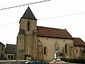
Saint-Agnan church with a war memorial in the foreground


_1.jpg)