
La Chapelle-Baloue
| La Chapelle-Baloue | ||
|---|---|---|
|
||
| region | Nouvelle-Aquitaine | |
| Department | Creuse | |
| Arrondissement | Guéret | |
| Canton | Dun-le-Palestel | |
| Community association | Monts et Vallées Ouest Creuse | |
| Coordinates | 46 ° 22 ′ N , 1 ° 35 ′ E | |
| height | 261-381 m | |
| surface | 8.68 km 2 | |
| Residents | 135 (January 1, 2017) | |
| Population density | 16 inhabitants / km 2 | |
| Post Code | 23160 | |
| INSEE code | 23050 | |

La Chapelle-Baloue is a municipality in the Massif Central in France . It belongs to the Nouvelle-Aquitaine region , the Creuse department , the Guéret arrondissement and the Dun-le-Palestel canton . It is bordered by Saint-Sébastien to the north, Crozant to the northeast, Lafat to the southeast, Saint-Germain-Beaupré (point of contact) to the south and Bazelat to the west .
Attractions
- Hall cross , Monument historique
- Notre-Dame de Lorette church, also a monument historique
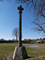
Floor cross

Notre-Dame de Lorette church

The Sedelle at La Chapelle-Balou

_1.JPG)

Population development
| year | 1962 | 1968 | 1975 | 1982 | 1990 | 1999 | 2008 | 2013 |
|---|---|---|---|---|---|---|---|---|
| Residents | 292 | 264 | 228 | 197 | 151 | 143 | 133 | 138 |
Web links
Commons : La Chapelle-Baloue - collection of images, videos and audio files