Saint-Michel (Paris Métro)
|
|
|
|---|---|

|
|
| Tariff zone | 1 |
| Line (s) |
|
| place | Paris V , Paris VI |
| opening | July 9, 1910 |
| Connected stations |
Saint-Michel - Notre-Dame → |

Saint-Michel is an underground station on line 4 of the Paris Métro . There is a possibility of changing to the S-Bahn -like RER lines B and C at the underground station Saint-Michel - Notre-Dame .
location
The station is located on the border of the Quartier de la Sorbonne in the 5th arrondissement and the Quartier de la Monnaie in the 6th arrondissement of Paris . It lies deep below the Place Saint-Michel and along the Rue Danton that leads off there.
Surname
It is named after the Place Saint-Michel and the Boulevard Saint-Michel that begins there . Saint-Michel is the biblical Archangel Michael , who is considered the slayer of the devil in Christianity . The Fontaine Saint-Michel, built in 1860 on the south side of the square, depicts this battle in a sculpture .
history
The station was commissioned on January 9, 1910 as part of the 3900 m long Châtelet - Raspail connection between the north branch opened in 1908 and the south branch of line 4 opened in 1909. On that day, the start of continuous operation of line 4 between Porte de Clignancourt in the north and Porte d'Orléans in the south. The tunnels and the Cité station were built using the caisson method (caisson). In 1979 the underground pedestrian connection to the RER station was opened.
description
The slightly curved station has side platforms under a tiled vault on two parallel tracks. Due to the close crossing under the southern arm of the Seine , at 15.4 m below the road surface, it is far lower than most Paris metro stations.
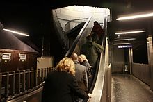
Because of the wet ground, caissons were installed, as was the case with the Cité station , which were manufactured on site. The central caisson with the shape of a round arch is 66 m long, 12.50 m high and 16.50 m wide. It was sunk horizontally in the excavation and takes up the central section of the station. At both ends there are vertically built elliptical caissons that extend from the floor to street level. In addition to the tracks and platforms, they take up the stairs and an elevator . The three caissons add up to the station length of 118 m, which is unusual for Paris.
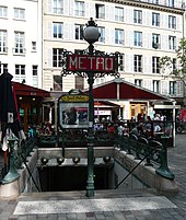
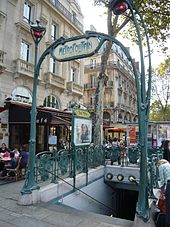
From the street, the station has five entrances, some of which bear Hector Guimard's signature . 1909, was at the station Saint-Michel for the first time at a metro access candelabra type Val d'Osne attached.
vehicles
Until 1928, five-car trains consisting of initially three twin-engine and later two four-engine railcars and sidecars ran on Line 4 . They were replaced by Sprague-Thomson trains , which were successively replaced by rubber-tired 6-car trains of the MP 59 series in 1966/67 . The MP 89 CC series is currently in use on Line 4 .
Surroundings
- The Latin Quarter, a traditional Parisian student district
- The Fontaine Saint-Michel , an ornamental fountain built in 1860 by Gabriel Davioud on a house facade with a sculpture by Francisque Joseph Duret
Remarks
- ↑ CC means "Conduite Conducteur" (driver-controlled), in contrast to the driverless type MP 89 CA
- ↑ Unlike the Quartier de la Sorbonne, the Quartier Latin is not a district according to the Paris administrative structure
Web links
literature
- Gérard Roland: Stations de métro. D'Abbesses à Wagram . 2003, ISBN 2-86253-307-6 .
Individual evidence
- ^ Gérard Roland: Stations de métro d'Abbesses à Wagram . Christine Bonneton, Clermont-Ferrand 2011, ISBN 978-2-86253-382-7 , pp. 195 .
- ↑ a b Jean Tricoire: Un siècle de métro en 14 lignes. De Bienvenüe à Météor . 2nd Edition. La Vie du Rail, Paris 2000, ISBN 2-902808-87-9 , p. 183 f .
- ↑ Jean Tricoire: op. Cit. P. 178 f.
- ↑ Jean Tricoire: op. Cit. P. 181.
- ↑ Mark Ovenden: Paris Underground . Penguin Books, London 2009, ISBN 978-0-14-311639-4 , pp. 68 .
| Previous station | Paris metro | Next station |
|---|---|---|
|
Cité ← Porte de Clignancourt |
|
Odéon Mairie de Montrouge → |
Coordinates: 48 ° 51 ′ 13.5 " N , 2 ° 20 ′ 39.4" E


