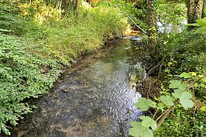
Salt Valley
|
"Salzetal" nature reserve
|
||
|
Salt Valley (2015) |
||
| location | Bad Salzuflen , Lippe district , North Rhine-Westphalia , Germany | |
| surface | 60.85 ha | |
| Identifier | LIP-039 | |
| WDPA ID | 329609 | |
| Geographical location | 52 ° 6 ' N , 8 ° 46' E | |
|
|
||
| Setup date | 2002 | |
The Salzetal area is a nature reserve designated in 2002 by the Detmold Regional Council (NSG number LIP – 039) in the north of the North Rhine-Westphalian town of Bad Salzuflen in the Lippe district in Germany .
location
The 60 hectare large nature reserve Salzetal is one natural area to Lippische Bergland . It extends north of Bad Salzuflen town center along the eponymous salts , between the Loose in the north, the landscape garden in the south, the highway 772 to the west and to the district deserts belonging Good Steinbeck in the east.
description
The salt flows here over a length of around 3.7 kilometers in a strongly meandering manner through its flat trough-shaped valley, a maximum of around 450 meters wide. The up to five meters wide salt is mainly bordered by willows and alders , in places also by ash - alluvial forest .
Protection purpose
The main protection purpose is the preservation and optimization of the salt vegetation by ensuring the local water regime as well as maintenance / grassland use tailored to the salt vegetation and a near-natural river meadow landscape with meandering river, (wet) grassland areas, fallow land and alluvial forest relics. The area is particularly valuable due to its high structural diversity, combined with a large number of near-natural biotope complexes. It also takes on important functions for the biotope network.
Biotope types
The following biotope types are designated in the Salzetal nature reserve :
- Alder forest accompanying the stream
- Stream middle course in the low mountain range
- Bachröhricht
- Disused wet and damp grassland
- Beech forest
- Mixed oak and beech forest
- Alder break forest
- Fettwiese
- Moist tall herbaceous corridor, extensive
- Bushes, group of shrubs
- Moist edge or tall herbaceous corridor accompanying the water
- dig
- Central mountain river
- Wet and humid meadow
- Lawn-Großseggenried
- Reeds of tall species
- Salt lawn
- Small standing water
- Riparian wood
Flora and fauna
flora

The following species (selection) from the flora worthy of protection are to be named:
- Ash willow ( Salix cinerea )
- Upright hedgehog ( Sparganium erectum )
- Broad-leaved cattail ( Typha latifolia )
- German ryegrass ( Lolium perenne )
- Lesser duckweed ( Lemna minor )
- Little clover ( Trifolium dubium )
- Burdock bedstraw ( Galium aparine )
- Garlic mustard ( Alliaria petiolata )
- Beach milkweed ( Glaux maritima ), only found in North Rhine-Westphalia
- Ufer-Wolfstrapp ( Lycopus europaeus )
- Forest ziest ( Stachys sylvatica )
See also
Web links
- "Salzetal" nature reserve in the specialist information system of the State Office for Nature, Environment and Consumer Protection in North Rhine-Westphalia
Individual evidence
- ↑ Map at www.protectedplanet.net, accessed on March 29, 2020.
- ↑ Protection goals of the LANUV .
- ↑ Biotopes worthy of protection (BK) in the protected area description of the LANUV .
- ↑ Information on habitats and species of the LANUV .


