
Sandkrug (Eckernförde)


Sandkrug (Danish: Sandkro , Low German: Sandkrog ) is a town on the Eckernförde Bay in Schleswig-Holstein , which today belongs entirely to Eckernförde . The Sandkrug site is located directly on federal highway 76 (B76) and in the immediate vicinity of the Baltic Sea beach (south beach). Sandkrug is named after an inn that stood there in the 18th to 20th centuries; The place has existed as a brickyard of the Windebyer brickworks since the middle of the 17th century . According to old maps, the name of the place itself should have been Tegelhof (f) or Zigelhof (f) at this time .
Limits

Since Eckernförde has renounced an official division into districts and a precise demarcation between them, the situation of a closed district, but separated from other parts of Eckernförde at the end of the Second World War, can be assumed for the district Sandkrug, supplemented by extensions clearly attributable to Sandkrug. The border lines to the Eckernförde district of Wilhelmsthal and to the communities Altenhof and Goosefeld are clear .
According to this, the beach section between the Goossee outlet and the level crossing at Berliner Straße / Preußerstraße on Bundesstraße 76 belongs to the Sandkrug area , the larger part of the Goosseewiesen with the area of the former Sandkrug warehouse , the border to the Wilhelmstal district runs south of the Eichkamp and Am Eichberg buildings, including Feldstedt , up to about the middle of Krumland . From there, a connecting line is to be drawn across the border of the Nettelbeckstrasse development that already existed at the beginning of the 1960s and the park-like footpath from Brennofenweg down to the Berliner Strasse / Preußerstrasse level crossing.
history
The name Sandkrug

Sandkrug was the name of an inn located near the beach , which belonged to Gut Marienthal . The inn that gave the place its name, which was first built as an excursion establishment and later expanded into a hotel, was closed in 1994. There are very different information on the question of when the inn existed, e.g. B. since 1840. or since 1870
This information can be wholly or partially countered by the fact that an inn was mentioned as early as 1841 in Hans Nicolai Andreas Jensen's book and also in 1854 in the topography of the Duchy of Schleswig . On April 21, 1848, near Altenhof and Sandkrug's beach, the battle at Altenhof took place: a contemporary map shows a total of six buildings in this area: Sandkrug (1 main building and 2 auxiliary buildings), less than 100 steps north of the Chausseehaus , around 400 steps south at the former Goosseekanal island house and on Altenhofer area beach station (the present Schmeerhörn having 1 primary and 1 secondary building).
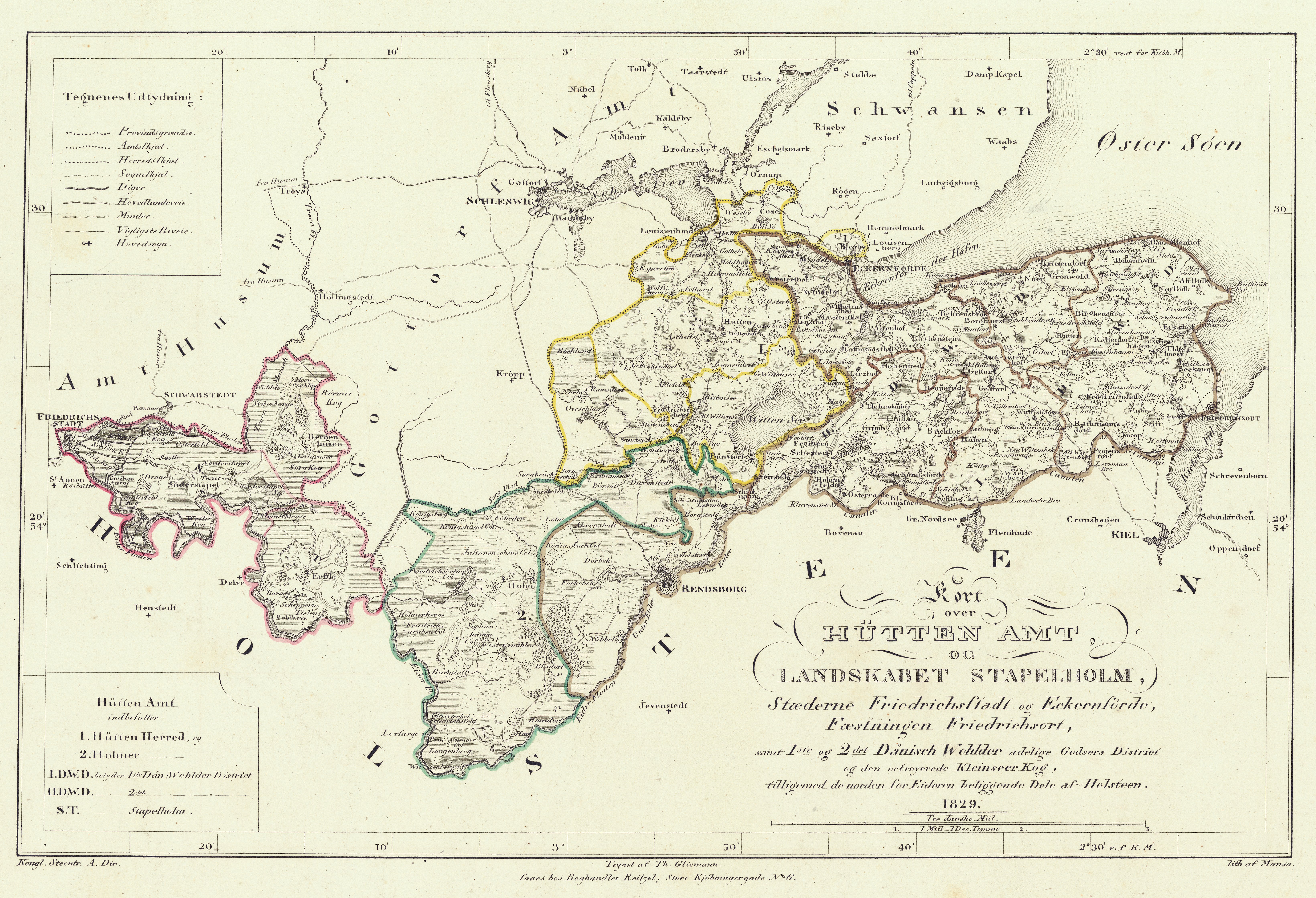
Already in 1829, was on the map huts Office og Landskabet Stapelholm of Theodor Gliemann the place name Sandkrug entered. Even earlier, namely as early as 1752, the place name for the Sand Kruge can be traced . Sand (e) as the name of a house appears in 1741.
Today the "Wohnpark Sandkrug" with 90 residential units is located on the site of the former inn.
The history


.jpg)
The history of Sandkrug did not just begin with the inn, but with a brick factory that had previously existed on this site and existed since the middle of the 17th century ( Windebyer brick factory ). On some old maps from the 17th and 18th centuries there are place names such as Zigelhof , Zigelhoff , Tegelhof , Tegelhoff , Teglhoff etc. at this point . The maps of that time were not yet so precise that the names could be assigned to exactly one point today ( compare e.g. the maps shown by Johannes Mejer from the years 1649 and 1652 from New State Description of the Two Duchies of Schleswig and Holstein and by Franz Johann Joseph von Reilly from 1791). Relatively certain seems to be in relation to today's Sandkrug in Johannes Mejer's map from 1652. There were also brickworks in the area in Kiekut and on the Marienthal and Hopesthal estates (both now part of Goosefeld ). Tiles and roof tiles made by the Windebyer brickworks were also exported to Copenhagen in the 18th century , where they were mainly used to rebuild the Danish metropolis after a large fire in 1728. In addition to the brickworks, there was also a lime kiln in today's Sandkrug. Bricks like lime were shipped from a loading point on the Goossee to the city port of Eckernfördes - a canal between Goossee and Eckernförde Bay existed roughly at the height of today's circular beach pavilion. The canal existed from the 17th century until 1873. The limestones came from Denmark by ship and were burned to lime on site. Quick lime was u. a. needed for the construction of the Rendsburg Christ Church and brought from Eckernförde by car to Schirnau and from there by ship to Rendsburg.
Looking further back in contemporary history, there are indications of a settlement in the area as early as the Neolithic and Bronze Age . At the end of the Second World War there were burial mounds from these epochs along the Cathedral Day and the Straße Auf der Höhe , which had to give way to building work . In the case of Cathedral Day, this applies above all to the area of today's buildings with house numbers 40 ff. And the properties with numbers 38 and 25. The property 25 (bakery) still had a Bronze Age grave mound with a stone box, the capstone, after the Second World War had an incision in the form of an antler pole, on property 38 large boulder blocks, the shape of girders and capstones of large stone chambers, came to light.

In 1841, the city of Eckernföhrde was not entirely inconsiderable , but also on the Rendsb. Ways, called Dohmstag, reported; The extent to which the urban lands also affect the Sandkrug site (the cathedral day - as it is spelled today - extends from Sophienhöhe to Sandkrug ) is not apparent from the text. Before that, 50 tons had moved from the city to Hof Wilhelmsthal and thus to the Marienthal estate . In the 19th century, around half a dozen buildings settled in the immediate vicinity of the inn, some of which from an administrative point of view belonged to the town of Eckernförde, the greater part of which belonged to the Marienthal district . When the Kiel – Flensburg railway was built from 1879 to 1881, the route had to be curved around the village. At the end of the 19th century, the Domstag uphill was the first building in the crossing area at that time (with today's street names ) Domstag / Auf der Höhe / Klintbarg recorded in the eastern triangle between Domstag and Auf der Höhe - at that time a corner of the Marienthal estate area reached to this Crossroads.
Sand pitcher in the 20th century
At the beginning of the 20th century, areas previously belonging to the Marienthal manor district were incorporated into the town of Eckernförde. From 1903 onwards there was a first branch for torpedo attempts of the Friedrichsort torpedo workshop in Sandkrug . In 1907 the lighthouse at Klintbarg was put into operation in the area.
Sandkrug developed into a district in 1909, when the Friedrichsort marine and torpedo workshop contacted the city's magistrate with the request to purchase a 140 meter long and 4000 m² strip of land in Sandkrug directly on the Baltic Sea to set up a torpedo firing range. At the beginning of 1910, negotiations began with the preparation of the purchase agreement. Despite uncertainties about the affiliation of the area, construction began on April 1, 1911 and the torpedo firing range was inaugurated on June 9, 1913. This was followed by administration and workshop buildings, a separate siding from Altenhofer Bahnhof, in 1914/15 its own coal-fired power station, etc. The siding was primarily used to transport coal for the company's own coal-fired power station.
Initially designed for 50 to 60 employees, the number of employees grew to 75 to 80 in 1913 and around 400 in 1933, only to explode under the Nazi dictatorship: in 1935 there were around 800 (including Eckernförde-Nord in the Louisenberg district ) , 1938: around 1700 (including Eckernförde-Nord and -Ost in Surendorf ), in 1939 it was around 3100, 1940 around 6200 and 1945: 24,404 (including E-Nord, E-Ost and branch offices in Neubrandenburg , Gotenhafen and Toplitzsee in Austria). According to the employment office, around 7,300 of these 24,000 employees worked directly in Eckernförde - the extent to which forced laborers and prisoners of war are included in this number is unknown.

Since workers and engineers from all over the Reich found employment at the torpedo firing range, from which the TVA Eckernförde developed in 1919 , and moved to Eckernförde, the procurement of living space became a problem. Within Eckernförde, new residential houses and settlements were gradually built, especially in Sandkrug near the TVA “headquarters” south, through publicly funded housing construction with the participation of the city of Eckernförde and the torpedo workshop: among other things, the Hoheluft was built with six wooden houses ( Finnish houses or Bonanza Houses ) for four families each (completed in March 1916 with prefabricated parts imported from Finland and with reindeer moss insulation), the buildings were built on Cathedral Day from the TVA up to around today's eastern junction Krumland (starting in 1920 on the southern side), the multi-family houses the Sehstedter Straße , the Eichberg development (1920s north side, from 1938 south side), the Klintbarg development, etc. Eigenheim Sandkrug was the name of this entire settlement with predominantly one, two and four-family houses. A look at the Pharus city maps from 1935 and 1940 shows that a new and isolated district had emerged: between Sandkrug and the other built-up areas of Eckernförd there were still considerable development gaps (with the exception of Hof Wilhelmstal) with predominantly agricultural use - the smallest gap existed to Sophienhöhe . This situation is impressively underpinned by a vertical aerial photo taken by British aerial reconnaissance on April 9, 1945. The situation remains unchanged on a map of Eckernförde from the early 1950s. This also corresponds with the expansion of the cathedral day into a street - even after the Second World War, the upper cathedral day towards the Rendsburger Landstraße was just a dirt road.
During the Second World War - in addition to further residential building - in and outside of Sandkrug on properties managed by the TVA (which were partly owned by the TVA, partly owned by the German Reich and only managed by the TVA), residential camps for around 4,500 employees and forced laborers were added which were mostly used as refugee camps after the end of the war. The camps set up in Sandkrug included the Sandkrug camp (partly designed for 150 people as of October 3, 1943) and the Domstag camp (designed for 460 people as of October 3, 1943). There were also smaller camps and individual barracks (e.g. at Eichkamp), some of which were also rented (e.g. on the property of the Hotel Sandkrug). The development was supplemented by flak positions and some buildings belonging to the Marine Flak Brigade I - Untergruppenkommando 211 Eckernförde on Brennofenweg.
Refugee camps and other barracks after the Second World War
The individual barracks in Sandkrug were of different sizes. The length was between approx. 10 meters and around 150 meters. After the Second World War, at least the following barracks were located in Sandkrug:
Under the administration of the city of Eckernförde
by Arnold Wicke listed
- Cathedral Day: 1 barrack (in 1952/53 there were still 56 refugees living here)
- Brennofenweg: 4 barracks ( 1952/53 still 80 residents )
- Eichkamp: 3 barracks ( 1952/53 still 32 residents )
- Sandkruglager: 2 barracks ( 1952/53 still 265 residents )
- Sehestedter Landstrasse: 3 barracks ( 1952/53 still 61 residents )
Under different management
- Domstag camp (8 barracks) ( 1952/53 still 282 residents )
- Hotel Sandkrug (1 or 2 barracks)
- Sand pitcher bearing (other parts)
Additional individual barracks
Additional small barracks were built in the street Hoheluft with the house numbers 7 and 9 at that time (together 9 residents) following the Finns houses.
Cathedral Day Camp
The Domstaglager (also: Domstaglager I , Domstag-Lager or Domstag-Lager I ) was built in 1939. In total, it consisted of eight individual barracks, each around 40 meters long, in the area of today's Feldstadt . According to information, it served as a makeshift housing camp for TVA engineers and partly as accommodation for prisoners of war or forced laborers during the Second World War. It was designed for 460 people as of October 3, 1943.
After the war ended, the camp served as a refugee camp. Shortly after the war, the Domstaglager was also likely to have been inhabited far beyond its original design capacity (see section: Sandkrug camp ). In 1952/53 there were still 282 residents registered in this camp, in 1953/54 there were still 250. In the second half of the 1950s, on Cathedral Day in front of the camp, the row of shops still existing today with three shops was built. The first occupancy consisted of a hairdressing salon (Splinter, still available), a fish shop (Sifferlin) and a grocery store ( Edeka- Petersen branch).
Sand pitcher camp
The Sandkrug-Lager (or also: Sandkruglager ) was established in 1939. The function of the camp was divided during the Second World War: it served about half as a residential camp for TVA employees and also as a refugee camp for the first arriving refugees, and the other part as a TVA administration and troop accommodation for the naval motor vehicle department. On October 3, 1943, the residential camp area was designed for 150 people and occupied by 72 TVA employees and refugees. The largest of the barracks was in the state of its maximum size in the shape of a rectangular border with an inner courtyard; the north wing was about 150 meters, the south wing about 130 meters, the length of the short sides was about 40 meters. In the period that followed, the Sandkrug camp - like the other camps - was likely to have been expanded. There were also factory halls of TVA Süd on the site and at the entrance to the site next to the railway line.
After the end of the Second World War, the camp was used as a whole as a refugee camp. Around 1000 people were housed here after the war. As early as 1945 or 1946, a camp kindergarten was set up in the camp, which the curative education department on the Baltic Sea Eckernförde cites as its origin. In 1947 the Sandkrug School was added as a camp school (see section: "Sandkrug School"). In 1952/53, the camp was still occupied by 265 people, a year later it was 164.
The barracks were demolished in the early 1960s, the factory halls remained in place until 1998.
Sand pitcher school
The Sandkrugschule was a primary and secondary school. It started operations in 1947 as an initially pure camp school in the Sandkrug camp for around 100 students. On June 20, 1950, the school moved to the transverse building (south wing) of the southernmost building (building D4) of the former TVA Eckernförde-Süd and at the same time became a primary and secondary school for almost the entire south of Eckernförde, the districts of Sandkrug and Sophienhöh, the Comprehensive houses of the Wilhelmstal court. Three large refugee camps ( Rendsburg camp , Sandkrug camp , Domstag camp ) and a few smaller ones belonged to the school district as well as the Weidenstraße settlement of bombed out Hamburgers and individual buildings closer to the city center outside Sandkrug and Sophienhöh. Immediately after moving to the former TVA building, there were a total of 633 pupils who were given lessons there. The D4 block was (next to the A1 block) one of two buildings that were not blown up on the TVA-Süd site on 7 December 1948 on behalf of the British military government. In addition to the Sandkrug School, this block (east, south and west wing together) also housed the city archive, a grocery store ( Konsum ), a butcher's shop (Rust), a hairdressing salon (Ziegler), at times a window cleaning company (Kortum), a school caretaker's apartment and 52 Housing units rented directly by the Federal Property Administration .
The special task in the Sandkrug School consisted in the integration of refugee children and local children as well as of refugee teachers and local teachers, some of whom had opposite lives during the Nazi dictatorship. After the Altenhofer Grundschule Jordanschule was dissolved in 1963, the pupils from the Altenhofer school area were assigned to the Sandkrugschule. In 1968 the school was closed - the school district was taken over by the newly created Albert Schweitzer School . One after the other, Messrs. Spiegelberg, Dronske and Jessen were the headmasters of the Sandkrug School.
Defense Technical Service 71

Test site 71 was set up in 1957 on the site of the former Eckernförde Süd torpedo testing facility (TVA Süd) and then gradually built up to 1968 on the former TVA south site and initially also in the former TVA factory buildings near the former Sandkrug warehouse. Today's Defense Technology Service for Ships and Naval Weapons of the German Armed Forces, Maritime Technology and Research (WTD 71) emerged from the former Test Center 71 with the integration of other independent services. The Federal Armed Forces Research Institute for Water- borne Sound and Geophysics was integrated into WTD 71 in 2009.
literature
- 100 years of torpedoes in the bay. In: Eckernförder Zeitung. June 8, 2013, (online) and June 22, 2013: A journey through military history. (on-line)
- Heimatgemeinschaft Eckernförde eV and department for regional history of the Christian-Albrechts-Universität Kiel: ECKernförde-Lexikon. Husum- Druck- und Verlagsgesellschaft, Husum 2014, ISBN 978-3-89876-735-4 , especially the keywords: Finnish houses, sand pitcher, sand pitcher school, torpedo research institute
- Tobias Hermann: Refugees and locals. The integration of 'strangers' in the Sandkrug school in Eckernförde. In: Tobias Hermann, Karl Heinrich Pohl (Hrsg.): Refugees in Schleswig-Holstein after 1945. Between exclusion and integration. Verlag für Regionalgeschichte, Bielefeld 1999, pp. 12–47.
- Helmut Jöhnk, Michael Packschies: Nature conservation in the Eckernförde Goossee meadows. (on-line)
- Oliver Krauss: Armaments and armament testing in German naval history with special consideration of the Torpedoversuchsanstalt (TVA). Dissertation. Kiel 2006.
- Klaus Nernheim: The Eckernförde economic area. Schmidt & Klaunig, Kiel 1958 (in another edition the work is a dissertation at the University of Kiel, 1958)
- Wolfgang Nolle: From the torpedo shooting range Eckernförde to the WTD 71. In: Jann-Markus Witt: Eckernförde - history of a port and naval city. Convent-Verlag, Hamburg 2006, ISBN 3-934613-96-9 .
- Lena Paschko, Heye Höltermann, Enno Schröder, Sven Köllner, Frederick Massmann: Beach profile south beach - Eckernförde. 2008 as part of the study project "Beaches and Beach Use in the Bay of Kiel" of the University of Kiel (online)
- Arnold Wicke: The fate of the expellees in the Eckernförde district. Publisher CJ Schwensen (Ed .: Heimatgemeinschaft Eckernförde), Eckernförde 1979.
Web links
- Expansion of Sandkrug to Wikimapia - however, the Sandkrug area is shown on this map too small on almost all sides
- Bunker-Kiel.com about Flak Brigade I
- Geschichtsspuren.de, forum about TVA Süd, bunker systems etc.
- City Eckernförde: suspected area J with detail from the Pharus map 1935 - a bad image of the Pharus city map from 1940 is here to see
References and comments
- ↑ the bunker tunnels embedded in the slope next to the railway line were also included in Sandkrug
- ↑ The school district of the former Sandkrug School - responsible for Sandkrug , Sophienhöhe including Rendsburger Lager and Hof Wilhelmsthal within the city - extended further north to the intersection of Rendsburger Strasse / Sehestedter Strasse / Adm.-Scheer-Strasse and also closed part of Berliner Strasse north of the level crossing with Preusserstrasse .
- ↑ Johannes von Schröder: Topography of the Duchy of Schleswig. 2., rework. Edition. Publishing house C. Fränckel, Odenburg i. H. 1854. (transcribed by the AKVZ project AKVZ - TOP2175 - Sandkrug - also mentioned by: Hans Nicolai Andreas Jensen, attempt at church statistics of the Duchy of Schleswig, 3rd delivery; AS Kastrup Verlag, Flensburg, 1841, p. 1220) .
- ^ Uwe Beitz: The hospitality industry in Eckernförde. Sutton Verlag, Erfurt 2012, ISBN 978-3-95400-067-8 , p. 67 ff.
- ^ Karl Friedrich Schinkel: Eckernförde - A walk through the city's history. Edited by Rolf Suhr - book and media publisher. 3. Edition. Haan 2009, p. 310.
- ↑ Heimatgemeinschaft Eckernförde eV and department for regional history of the Christian-Albrechts-Universität Kiel: ECKernförde-Lexikon. Husum- Druck- und Verlagsgesellschaft, Husum 2014, ISBN 978-3-89876-735-4 , p. 286.
- ↑ Hans Nicolai Andreas Jensen: Attempt at church statistics for the Duchy of Schleswig. 3. Delivery. AS Kastrup Verlag, Flensburg 1841, p. 1220.
- ↑ Johannes von Schröder : Topography of the Duchy of Schleswig. Oldenburg (Holstein) 1854, p. 341. (online) , and 445 (online) .
- ^ GL Martens: Special map of the battle near Altenhof. In: Diary of a volunteer of the vd Tann'schen Corps. Hamburg 1848, p. 20; Map shown in: Walter Wilde: Louise Aston - a women's rights activist in the battle of Altenhof. In: Heimatgemeinschaft Eckernförde eV: Yearbook 2007. P. 187 ff, P. 190.
- ↑ see here
- ↑ Landesarchiv Schleswig-Holstein ("Gottorf-Archiv"), Section 195, No. 440 according to information provided by Kr. Hald: Stednavne i Egernførde. In: Harald Jørgensen, OM Olesen, Frants Thygesen (Red.): Egernførde bys historie. Studieafdelingen ved Dansk Centralbibliotek for Sydslesvig. Flensburg 1980, ISBN 87-980393-5-0 , p. 32 ff., 39.
- ^ Karl Friedrich Schinkel: Eckernförde - A walk through the city's history. Edited by Rolf Suhr - book and media publisher. 3. Edition. Haan 2009, pp. 310-311.
- ↑ the round pavilion was built at the beginning of the 1950s; Architect: Petrick
- ^ Friedrich Schröder: Rendsburg as a fortress. Karl Wachholtz Verlag , Neumünster 1939, p. 72.
- ↑ Hans Jockisch: Older and more recent prehistory finds from the southern part of Eckernfördes. In: Yearbook of the home community of the Eckernförde district. 1966, p. 128 ff., 128 f.
- ^ Hans Nicolai Andreas Jensen, attempt at church statistics of the Duchy of Schleswig, 3rd delivery, p. 1217; AS Kastrup Verlag, Flensburg, 1841, p. 1207 f.
- ↑ Johannes von Schröder: Topography of the Duchy of Schleswig. 2., rework. Edition. Publishing house C. Fränckel, Odenburg i. H. 1854. (transcribed by the AKVZ project AKVZ - TOP2850 - Wilhelmsthal )
- ↑ At that time, Sandkrug was definitely inhabited: this is clearly documented by an emigrant from Sandkrug in 1881, emigration from the Eckernförde district in the 19th century , No. 267
- ↑ Königlich Prussische Landes -aufnahme, Mestischblatt Eckernförde , 1877 with additions 1895; According to the city administration in suspected area J (see web links), the first house still standing here was built around 1910.
- ↑ Today's Sehestedter Straße existed only a few meters as part of today's Brennofenweg , which was then a dirt road; the traffic from the city to Marienthal ran via Klintbarg and Höhenweg and flowed a little south of the level crossing (today the confluence of Preusserstraße ) into today's Berliner Straße (see photo on ndr.de ). The path width was probably narrowed in 1939/40 by bunker tunnels embedded in the slope or the path was moved further upwards due to this measure
- ↑ according to the address book and business manual for the town and district of Eckernförde (published by C. Heldt's bookstore) from 1897, Sandkrug still belonged to Marienthal (page 97); since the municipality border ran through the middle of the town at that time, this only applied to the southern part of the town
- ↑ Gerd Lüders: The fateful year 1948 of the torpedo research institutes in Eckernförde and Surendorf. In: Yearbook of the home community Eckernförde. 1993, pp. 79 ff., 79 f .; according to the table of contents (p. 6) Spelling of the author: Geert Lüders
- ↑ Krauss, p. 115 ff.
- ↑ Around 1920, the TVA site and its facilities were added in a preliminary draft for a revision of the Eckernförde measuring table sheet on the basis of the 1895 publication. On the editing instruction "Do not enter torpedo shooting range, shed on the beach and connecting railway in the maps to be published", this part of the official maps was not renewed
- ↑ Nolle, p. 82.
- ↑ including the locksmith Werner Kuhnt , who played a game for the German national team as a soccer goalkeeper
- ↑ Krauss, pp. 117, 230 ff.
- ↑ Krauss, p. 251: increased use of foreign workers and prisoners of war after the outbreak of war - Krauss also points out in several places that the exact number of workers in Eckernförde cannot be determined, on page 12 a number of almost 10,000 is Called the end of the war
- ^ Krauss, p. 117.
- ↑ Stefan Deiters: 'Bonanza houses' shape the cityscape. In: Kiel News. - Regional edition: Eckernförder Nachrichten of November 25, 1995.
- ↑ see: City of Eckernförde: Suspected area J - Link under web links
- ↑ Klaus formers Heim, S. 61st
- ^ While on the Pharus plan of 1935 C. v. Bruyn, although the northern buildings on the eastern cathedral day are missing, they are already present in the film Eckernförde 1935 - released on DVD by Willie Eulert in 2003. Either the development that existed in 1935 had not yet been included in the Pharus plan and / or the film was shot a little later than 1935
- ↑ illustrated in: Karl Friedrich Schinkel: Eckernförde - a walk through the city's history. 2nd Edition. Publisher Manfred Goos, Horn-Bad Meinberg 2002, p. 418.
- ↑ Main surveying office SH: Ostseebad Eckernförde without ang. Date (published between 1950 and 1955: evidence: Sandkrugschule in the former TVA-D4 building already, Kleinbahnstr. To Owschlag still, Krumland and central development of Domstag not yet available, Broosbyer Koppel still part of Windeby)
- ↑ Hans Jockisch: Older and more recent prehistory finds from the southern part of Eckernfördes. In: Yearbook of the home community of the Eckernförde district. 1966, p. 128 ff., 128
- ↑ Krauss, pp. 217, 250, 395.
- ↑ The largest of these camps in Eckernförde were the Rendsburg camp (designed for 1356 people) and the Louisenberg camp (occupied by approx. 1200 forced laborers)
- ↑ Most of the buildings in this unit, also known as the Flak Battery Zack , were on the Ykernburg site outside Sandkrug (between Rendsburger Strasse , Windebyer Weg and Admiral-Scheer-Strasse ); there were also positions in Altenhof , Barkelby , Bosniseck in the municipality of Waabs , Hemmelmark , Marienthal and Osterby
- ^ Arnold Wicke: The fate of the expellees in the Eckernförde district. Heimatgemeinschaft Eckernförde, 1979, p. 43.
- ↑ it would be the barracks in the area Domstag / current Berliner Straße / calibration fount, partly in sources other than Domstag II camp and probably as officers' camp was called
- ↑ Information on the number of residents in 1952/53 according to Klaus Nernheim: The Eckernförde economic area. Schmidt & Klaunig, Kiel 1958, Appendix-II, p. 61.
- ↑ Klaus Nernheim, p. 60.
- ↑ Klaus Nolle, p. 60.
- ^ Jürgen Andres: Foreign workers in Eckernförde. In: Kurt Hamer , Karl-Werner Schunck, Rolf Schwarz: Forgetting + Displaced. 3rd, supplemented edition. Schleswiger Druck- und Verlagshaus, Schleswig 1995, p. 233 f.
- ↑ Krauss, pp. 217, 250, 395.
- ↑ Klaus Nernheim, Appendix-II, p. 61.
- ↑ Klaus Nernheim, p. 60.
- ↑ Krauss, p. 395.
- ^ Report by Christian Schreiber In: Arnold Wicke, p. 118.
- ↑ here (press article on the history of curative education) , here (history of curative education) (Fig. 4) and here (Eckernförder Zeitung from February 12, 2010 on the death of Christian Schreiber) ; Christian Schreiber In: Arnold Wicke, p. 118.
- ↑ Nernheim, Appendix II, p. 61.
- ↑ On the death of Pastor Christian Schreiber. In: Eckernförder Zeitung. February 12, 2010 (www.shz.de)
- ↑ At times, 2,400 students had to attend the Willers-Jessen-Schule beforehand . a. was also responsible for the south of the city. Ref .: Hans Mathiessen: A Christmas party 20 years ago in the Sandkrug School, Eckernförde. In: Heimatgemeinschaft Eckernförde eV: Yearbook. Eckernförde 1974, p. 23 ff., 23.
Coordinates: 54 ° 27 ' N , 9 ° 51' E