Sandy Springs (Georgia)
| Sandy Springs (Georgia) | |
|---|---|
 View of Sandy Springs with the King and Queen Towers of the Perimeter Center |
|
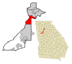
| Location of Sandy Springs in Georgia | |
| Basic data | |
| Foundation : | December 2005 |
| State : | United States |
| State : | Georgia |
| County : | Fulton County |
| Coordinates : | 33 ° 56 ′ N , 84 ° 22 ′ W |
| Time zone : | Eastern ( UTC − 5 / −4 ) |
| Residents : | 93,853 (as of 2010) |
| Population density : | 960.6 inhabitants per km 2 |
| Area : | 101.0 km 2 (approx. 39 mi 2 ) of which 97.7 km 2 (approx. 38 mi 2 ) are land |
| Height : | 333 m |
| Postcodes : | 30328, 30327, 30338, 30342, 30350, 30358 |
| Area code : | +1 404 470, 678, 770 |
| FIPS : | 13-68516 |
| GNIS ID : | 0332975 |
| Website : | www.sandyspringsga.org |
| Mayor : | Rusty Paul |
Sandy Springs is a city in northern Georgia in the United States . It is a suburb of Atlanta .
geography
Geographical location
Sandy Springs is located in Fulton County in the US state of Georgia . The city is a northern suburb of Atlanta and part of the Atlanta-Sandy Springs-Marietta Metropolitan Statistical Area , the most populous metropolitan area in Georgia. Sandy Springs is bordered to the west by Cobb County , to the north by the city of Roswell and to the east by the city of Dunwoody in DeKalb County .
climate
Sandy Springs has an east side climate with warm temperate summers and cool winters. Precipitation falls all year round, with the maximum values being reached in the months of January to March.
|
Average Monthly Temperatures and Rainfall for Sandy Springs
Source:
|
||||||||||||||||||||||||||||||||||||||||||||||||||||||||||||||||||||||||||||||||||||||||||
history
Foundation and name origin
In 1842 the Austin-Johnson House was built on what is now Johnson Ferry Road. It's the oldest house in Sandy Springs. After the construction of the Interstate Highway system began in 1956 with the signing of the Federal Aid Highway Act, housing construction began to flourish in the city. Georgia State Route 400 and Interstate 285 have connected Sandy Springs to Atlanta since the 1960s and 1970s .
In the 1970s, a debate began over local government ( incorporation ) after Atlanta tried to incorporate Sandy Springs through a state law. In a referendum on local self-government on June 21, 2005, 94 percent of the residents eligible to vote voted in favor of self-government in the city. On December 1, 2005, the city formally became independent.
The name of the city comes from sandy springs in their area. The springs are now a protected cultural and historical site.
Population development
| Population development | |||
|---|---|---|---|
| Census | Residents | ± in% | |
| 1980 | 46,877 | - | |
| 1990 | 67,842 | 44.7% | |
| 2000 | 85,781 | 26.4% | |
| 2010 | 93,853 | 9.4% | |
| Source: | |||
In 2010, 93,853 people lived in Sandy Springs. The population has been growing for several decades. In the 2000 census, only 85,781 people lived in the city's area. All figures before 2005 relate to the time before the city was founded, but relate to today's urban area.
Economy and Infrastructure
Established businesses
Sandy Springs is home to several major corporations including United Parcel Service , Newell Rubbermaid and First Data . The city's major business districts are along Roswell Road and in the Perimeter Center . Sandy Springs shares the latter with the neighboring town of Dunwoody. There are numerous high-rise buildings in the Perimeter Center, including the two twin towers of the Concourse at Landmark Center , which define the silhouette of the city. The twin towers are popularly referred to as The King and Queen Towers because of their resemblance to chess pieces .
supporting documents
- ↑ City of Sandy Springs: City of Sandy Springs - Mayor's Office . Retrieved February 1, 2016.
- ^ Monthly Averages for Sandy Springs, GA . Weather.com. Retrieved April 16, 2011.
- ^ Census of Population and Housing (1790-2000) . US Census Bureau . Retrieved April 16, 2011.
