
Zanzibar City
| Zanzibar City | |||
|---|---|---|---|
|
|||
| Coordinates | 6 ° 10 ′ S , 39 ° 12 ′ E | ||
| Basic data | |||
| Country | Tanzania | ||
| Unguja Mjini Magharibi | |||
| District | Urban (Mjini) | ||
| ISO 3166-2 | TZ-15 | ||
| Residents | 501,459 (August 28, 2012) | ||
| Post Code | 71101-71120 | ||
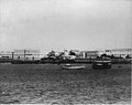
 Zanzibar old town (2012)
|
|||

Zanzibar City ( Swahili Zanzibar (Jiji) , English Zanzibar City ) is the largest city on Unguja Island , better known as Zanzibar. Zanzibar City is also the capital and seat of government of the semi-autonomous state of Zanzibar in Tanzania, comprising the two islands of Pemba and Unguja . In the administrative structure of Tanzania, Zanzibar City is one of the three districts ( wilaya ) of the region ( mkoa ) Unguja Mjini Magharibi , namely the Urban (Mjini) district . The population is 501,459 (as of August 28, 2012).
Internationally accessible Zanzibar City is through the Zanzibar Airport , around six kilometers south of the old town of Stone Town .
history


From 1698 Arabs from Oman built the first stone buildings and the fort , the extensions of which 80 years later left the shape still visible today. At the beginning of the 19th century there were only a few huts and a castle in the city of Zanzibar; in 1842 there were only five stores. In 1832, initially provisionally, then finally in 1840, the Sultan decided to move the Omani court to Zanzibar. With the regent, many influential and wealthy families moved to the new capital and the Arab population skyrocketed to 5,000. As early as the mid-1830s, the city had a population of 17,000. The US consulate was built in 1837 as the first “western” building .
By 1883, built by Sayyid Barghash Bait al-'Adschā'ib (now the House of Wonders ) and the lighthouse next to the Maruhubi - Sultan Palace the city got its first power station . By 1888 the city had over 3,000 houses and 80,000 inhabitants.
Culture
Almost all of the city's residents are Muslim . Their way of life is shaped accordingly. The Zanzibari culture is heavily influenced by Arabic, Indian and other Asian influences. With colonialism , western elements were also incorporated into the culture.
The Zanzibar International Film Festival (ZIFF) takes place annually in the old town . The ZIFF is an important event for African film productions and films with an African theme. The Festival of the Dhow Countries / Tamasha la Nchi za Jahazi will be held at the same time . The culture of Swahili , the coastal inhabitants of East Africa, is shown and celebrated in all its forms.
Zanzibar City is the seat of the Bishop of Zanzibar
Population development
The following overview shows the number of inhabitants by area since the 1978 census.
| year | population |
|---|---|
| 1978 (census) | 110,531 |
| 1988 (census) | 157,634 |
| 2002 (census) | 320.701 |
| 2012 (census) | 501.459 |
Districts
The most famous district is the historic center Stone Town (Swahili: Mji Mkongwe ), which since 2000 as a World Heritage Site under the protection of UNESCO stands. It covers about 96 hectares. Most of the brick houses were built from coral rock about 150 years ago , and many are being renovated and restored. The Aga Khan Trust For Culture (Historic Cities Program) , which has already renovated the Old Dispensary and the Old Customs House, is making great efforts in this regard . In addition, in cooperation with the Stone Town Conservation and Development Authority, a comprehensive plan for the preservation and design of the historic old town was drawn up, which includes the redesign of the Forodhani Garden on the waterfront .
Close to the old town is the city's port, from which ferries and dhows run to Dar es Salaam on the Tanzanian mainland and to Pemba.


Michenzani is one of the other residential areas in Zanzibar City with a row of houses made of prefabricated buildings , which was built in the 1970s with the help of the GDR in the style of the GDR architecture of the time.
The official neighborhoods of the city of Zanzibar are the 40 wards (shehia) :
| No. | Ward (Shehia) | Population August 1, 2002 |
Name meaning |
|---|---|---|---|
| 1 | Shangani | 2062 | |
| 2 | Mkunazini | 1829 | |
| 3 | Kiponda | 971 | |
| 4th | Malindi | 1525 | |
| 5 | Mchangani | 1205 | the sands |
| 6th | Mlandege | 1225 | |
| 7th | Muembe Ladu | 1752 | |
| 8th | Gulioni | 1283 | |
| 9 | Macadara | 2837 | |
| 10 | Shaurimoyo | 4296 | |
| 11 | Muembe Makumbi | 4384 | |
| 12 | Chumbuni | 5360 | |
| 13 | Kwamtipura | 4696 | |
| 14th | Kilimahewa | 4095 | airy hill |
| 15th | Amaani | 2859 | |
| 16 | Nyerere | 6810 | after Julius Nyerere |
| 17th | Sebleni | 2458 | in the sitting room |
| 18th | Magomeni | 5697 | |
| 19th | Mpendae | 6258 | love one another |
| 20th | Urusi | 6291 | Russia |
| 21st | Kilimani | 1524 | on the hill |
| 22nd | Miembeni | 2601 | mango trees |
| 23 | Kikwajuni Juu | 1323 | upper small tamarind |
| 24 | Kikwajuni Bondeni | 1283 | Valley of the small tamarind |
| 25th | Kisima Majongoo | 2235 | well of the millipedes |
| 26th | Vikokotoni | 946 | gravel pit |
| 27 | Mwembetanga | 1488 | mango tree of the tanga variety |
| 28 | Mwembeshauri | 1118 | mango tree of the shauri variety |
| 29 | Rahaleo | 1038 | happiness today |
| 30th | Kwaalamsha | 1848 | |
| 31 | Mikunguni | 1669 | |
| 32 | Mkele | 3180 | |
| 33 | Muungano | 2638 | United |
| 34 | Sogea | 2359 | move over |
| 35 | Jang'ombe | 3011 | |
| 36 | Kidongo Chekundu | 1165 | |
| 37 | Matarumbeta | 1394 | the trumpets |
| 38 | Kwahani | 2211 | |
| 39 | Kwaalinato | 2647 | |
| 40 | Karakana | 3213 | workshop garage |
| Zanzibar Urban | 206.292 |
Finally, the shehia Karakana was created by outsourcing from Chumbuni.
sons and daughters of the town
- Peter Lohmeyer (1911–2002), German naval officer
- Freddie Mercury (1946–1991), born Farrokh Bulsara, rock singer
photos
Zanzibar city in colonial times

Old fortress
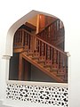
Stone Town, House Of Wonders (detail)

Stone Town , market


Climate table
| Zanzibar | ||||||||||||||||||||||||||||||||||||||||||||||||
|---|---|---|---|---|---|---|---|---|---|---|---|---|---|---|---|---|---|---|---|---|---|---|---|---|---|---|---|---|---|---|---|---|---|---|---|---|---|---|---|---|---|---|---|---|---|---|---|---|
| Climate diagram | ||||||||||||||||||||||||||||||||||||||||||||||||
| ||||||||||||||||||||||||||||||||||||||||||||||||
|
Average monthly temperatures and rainfall for Zanzibar
Source: Tanzania Meteorological Agency, data: 1971–2000
|
|||||||||||||||||||||||||||||||||||||||||||||||||||||||||||||||||||||||||||||||||||||||||||||||||||||||||
Web links
swell
- ^ Tanzania: Regions and Cities - Population Statistics in Maps and Tables. Retrieved February 7, 2018 .
- ^ Magharibi B, District Profile. (PDF) The Revolutionary Government of Zanzibar, June 2017, p. 1 , accessed on January 4, 2020 .
- ↑ Zanzibar International Film Festival (ZIFF)
- ^ Tanzania: Regions and Cities - Population Statistics in Maps and Tables. Retrieved January 7, 2019 .
- ↑ Aga Khan Trust For Culture - Historic Cities Program ( Memento of May 11, 2006 in the Internet Archive )
- ↑ 2002 Population and Housing Census. Archived from the original on November 18, 2008 ; accessed on March 4, 2015 .
- ↑ Tanzania Meteorological Agency: Climate information Zanzibar. World Meteorological Organization, accessed October 27, 2012 .