Pemba
| Pemba | ||
|---|---|---|
| Pemba with secondary islands | ||
| Waters | Indian Ocean | |
| Archipelago | Zanzibar Archipelago | |
| Geographical location | 5 ° 13 ′ S , 39 ° 44 ′ E | |
|
|
||
| length | 67 km | |
| width | 22 km | |
| surface | 984 km² | |
| Highest elevation | 50 m | |
| Residents | 406,808 (2012) 413 inhabitants / km² |
|
| main place | Chake chake | |
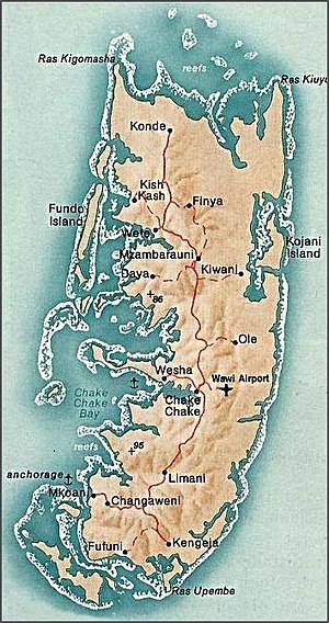
Pemba ( Arabic الجزيرة الخضراء al-Jazira al-Chadra ' , DMG al-Ǧazīra al-ḫaḍrāʾ ' the green island '; Roman name of the island in antiquity: Pyralax ) is with 984 km² (north-south extent 67 km; east-west extent up to 22 km) and approx. 410,000 inhabitants the second largest island of the East African Zanzibar archipelago . Together with the island of Unguja, 50 km to the south,and numerous small side islands, Pemba forms the semi-autonomous state of Zanzibar in Tanzania .
geography
Compared to the neighboring island of Unguja (island of Zanzibar) , Pemba is more fertile and also more hilly. Pemba has various smaller offshore islands (see Zanzibar Archipelago ), some of which are populated, and a number of bathing beaches, some of which are difficult to access (with otherwise strong mangrove growth or coral rock coast). The main places are Chake-Chake (airport), Wete (parliament building), Mkoani (ferry port), Kengeja , Micheweni and Konde .
population
Over 95% of the residents of Pembas are Muslim , u. a. from the Shirazi people . Due to the largely lack of social systems, family ties and security for old age through children are very important. In the country the children have to help with household chores and agriculture at an early age.
history

For most of the story, Pemba shares the fate of its neighbor Zanzibar .
politics
Politically, Pemba belongs to the semi-autonomous state of Zanzibar in the United Republic of Tanzania. Since the early 1990s, a strong political opposition movement ( Civic United Front - CUF) has developed on Pemba against the former unity party CCM ( Chama Cha Mapinduzi ).
The government of the Republic of Zanzibar has recently called for heightened environmental awareness . Fishing with poison or explosives should be completely stopped, the children are taught about sustainable cultivation methods for crops. Passages from the Koran underpin the new green movement.
economy
Agriculture
The main crops are cloves , but also coconuts , rice , nutmegs , bananas , sugar cane , mango , jackfruit , papaya , pineapple , bungo , okra , tomato , pepper and cassava .
During the clove harvest season, which lasts several months, mats are laid out in many places on the island, on which the cloves (Swahili: karafuu) are laid out to dry for several days. The carnation harvest used to attract migrant workers from the mainland each year; the harvesting work is dangerous because the not yet blooming stems have to be picked by hand from the very tall clove tree. However, the decline in world market prices for cloves only allows for low wage payments, so that nowadays mostly local workers are employed if necessary.
Industry and Infrastructure
There are no noteworthy industrial companies on the island. Due to the deep sea trench between Pemba and Zanzibar as well as the mainland, Pemba could not be supplied with electricity from outside until 2010. There was therefore an oil power plant in Wesha near Chake-Chake , which, however, could not supply the whole island. Frequent power outages were therefore the order of the day or only part of the island was alternately supplied with electricity. On June 3, 2010, a 36 kV submarine power cable (78 km length, depth up to 850 m) was activated, with which the island is now largely reliably supplied with electricity from the mainland from Tanga .
Natural resources
Oil deposits near Tundaua on the west coast have been known for a long time ( Tundaua oil seep ). In 2010, licenses for onshore and offshore exploration of oil and gas were granted.
tourism
In terms of tourism, Pemba, in contrast to Zanzibar, has so far only been poorly developed despite its diverse scenic attractions and now relatively good road network. There are mostly high-priced hotels on some beaches that can usually only be reached with arranged transport or a rental car; In the places Chake-Chake , Wete and Mkoani there are several hotels or guest houses of different categories.
To promote tourism, the Department of Surveys and Mapping in Chake-Chake, with the support of the Beuth University of Applied Sciences Berlin, has been issuing a map with a detailed travel guide and city maps since 1992.


