
Saußbach (Erlau)
| Saußbach | ||
 Saußbach in the Saußbachleite nature reserve |
||
| Data | ||
| Water code | DE : 191142 | |
| location |
Upper Palatinate-Bavarian Forest
|
|
| River system | Erlau | |
| Drain over | Erlau → Danube → Black Sea | |
| origin | Originating the Saußbachs at the mouth of the cross Bach in the Rosenau Bach 48 ° 43 '45 " N , 13 ° 39' 38" O |
|
| Source height | at about 603 m | |
| muzzle | north-west of the Saußbachmühle from the left and east into the upper Erlau coordinates: 48 ° 43 ′ 13 ″ N , 13 ° 34 ′ 31 ″ E 48 ° 43 ′ 13 ″ N , 13 ° 34 ′ 31 ″ E |
|
| Mouth height | approx. 449 m | |
| Height difference | approx. 154 m | |
| Bottom slope | approx. 18 ‰ | |
| length | approx. 8.6 km | |
The Saußbach is a brook in the Bavarian Forest in Lower Bavaria , which, together with the Rosenaubach, forms a continuous river system with a length of approx. 14.4 km. The name Rosenau Bach denotes the upper run between the source region and the inflow cross stream, Saußbach the lower portion to the mouth of the Eger .
The largest tributary is the Schauerbach , flowing south of the Erlauzwiesel from the left, which forms a further river system with a large catchment area with the Grundmühler Bach , the Steinerfurthbach , and the Holzlenzenbach .
geography
Run
Rosenaubach (upper course)
The Rosenaubach rises south of the Zillberg (828 m above sea level) and north-northeast of the town center of the parish village of Jandelsbrunn at an altitude of ( 682 m above sea level ). After about 200 m, another source branch flows towards it at an altitude of ( 669 m above sea level ), which rises at an altitude of ( 680 m above sea level ). A third source branch follows after a further 260 m at an altitude of ( 652 m above sea level ). This source branch rises at an altitude of ( 663 m above sea level ).
The Rosenaubach flows down from its headwaters first in a southerly direction before turning west of the Jandelsbrunn hamlet Jandelsbrunnermühle in a predominantly westerly direction. Here the Pfeierwiesgraben joins from the left and very last northeast and about 100 meters further west from the left and very last southeast another stream coming from the southeast and from the hamlet of Weid . The Rosenauchbach then touches the north-eastern end of the Jandelsbrunn industrial park, where it partially runs in a pipe system, before it joins the Zanglinggraben from the left to the south-east of the Freud desert and, at the very end, from the north . Approx. 200 meters further on, from the right and very last northeast, there is a stream coming from the hamlet of Schlag . Shortly before the sewage treatment plant south of the Mösing wastewater treatment plant, the Kramerbach flows from the left and very last south-southeast into the Rosenaubach, before the Kaltwassergraben joins approx. 400 meters further from the right and very last northeast . From here the Rosenaubach flows in a westerly direction through the little wood of Weidholz, at the western end of which the direction of the river swings to the south. From the right and very last north-north-east and north-west, two small streams flow from the direction of the village of Poppenreut . Approx. 500 meters further on, a short ditch is added from the left and very last south-southeast, before the Rosenaubach at the fish ponds east of the hamlet of Reichermühle turns again at the tributary of the Kreuzbach from the left and from the south in a westerly direction.
Saußbach (lower course)
Below the mouth of the Kreuzbach , the Rosenaubach is known as Saußbach . From here it first flows westwards in the direction of the hamlet of Reichermühle, before it assumes an increasingly south-westerly direction of the river, to meet the northeastern end of the artificial Erlauzwieseler See east of the Waldkirchen village of Erlauzwiesel .
The Erlauzwieseler See is a 7.68 hectare reservoir that was created in 1970 and is dammed with a dam at the southwest end to an altitude of ( 595 m above sea level ) (at the destination ). The Saußbach flows around the Erlauzwieseler See - only separated by a path - on its east and south banks without feeding it. In the southeastern area of the reservoir, an estuary of the Schauerbach flows from the left and south into the Saußbach. According to the map, this inflow is one meter below the target of the lake ( 594 m above sea level ). At the western end of the reservoir, a second estuary of the Schauerbach flows from the left and east-southeast .
From the Erlauzwieseler See the Saußbach flows westwards in the direction of the wasteland Reutmühle and feeds a mill ditch approx. 300 m downhill, which also flows into the Reutmühle south of the Saußbach and is used to generate electricity.
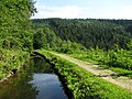
Down the Reutmühle, the Saußbach initially takes a westerly direction of the river, before it turns south of the hamlet Fresck in a southerly direction and at ( 582 m above sea level ) north of Fischerhäusl takes in the Schwarzbach coming from the left and east . Approx. The Saußbach is dammed 400 m to the west by a small dam. At this dam a ditch branches off to the right of the Saußbach, which follows the slope in a north-westerly direction, while the Saußbach flows downwards in the Saußbachklamm, which is a little further south . In this gorge, which runs in a north-westerly direction, the average gradient over the approximately 940 meters to the hamlet Saußmühle ( 504 m above sea level ) is about 85 per thousand. The Saußbachklamm is part of the Saußbachleite nature reserve, which is around 20 hectares in size .
The ditch branching off above the gorge continues for about 1120 m parallel to the slope, before it flows northeast of the Saußmühle with a height difference of about 78 m, partly underground and partly above ground, to the Saußmühle and is used to generate electricity. According to the Stadtwerke Waldkirchen, the Saußmühle hydropower plant was commissioned in 1951 and generates an output of 463 kW with the help of two Francis turbines .
Below the Saußmühle, another ditch branches off to the left of the Saußbach, which initially follows the wooded valley along the contour lines, while the Saußbach, a little further north, circles around half of the Saßberg ( 508 m above sea level ) and in the direction of the Waldkirchener Einöde Saßbachmühle flows. The ditch that runs along the slope runs about 910 m southwest on the wooded slope, before it flows - initially above ground, later underground - in a northwest direction to the privately operated Saßbachmühle.
About 200 m northwest and below the Saßbachmühle the Saußbach flows from the left and east ( 449 m above sea level ) into the upper Eger.
The river system from Saußbach and Rosenaubach has a total length of 14.4 km and - based on the height information of the origin and mouth - an average gradient of approx. 16 ‰. The lower section of this river system, called Saußbach, has a length of 8.63 km and a gradient of approx. 17.8 ‰.
Tributaries
Rosenaubach (upper course)
From the source to the Saußbach . Selection.
Origin of the Rosenaubach at approx. 828 m above sea level. NHN .
- Pfeiferwiesgraben from the left and northeast from the direction of the Jandelsbrunn hamlet Jandelsbrunnermühle
- Unmarked stream from the left and southeast from the direction of the Jandelsbrunn hamlet Weid
- Zanglinggraben from the right and north
- Unmarked stream from the right and north-northeast
- Kramerbach from the left and south-southeast from the direction of the parish village of Jandelsbrunn
- Cold moat from the right and northeast
- Unmarked stream from the right and north-northeast
- Unmarked stream from the right and northwest
- Unmarked stream from the left and east-southeast
- Kreuzbach from the left and south from the direction of the parish village of Wollaberg
Saußbach (lower course)
From the Rosenaubach to the confluence with the Erlau. Selection.
Origin of the Saußbach at approx. 603 m above sea level. NHN at the confluence of the Kreuzbach and the Rosenaubach.
- Schauerbach over two estuary arms from the left and south (1st estuary) or left and east-southeast (2nd estuary)
- Schwarzbach from the left and east
Mouth of Saußbach at approx. 449 m above sea level. NHN northwest of the hamlet of Saßbachmühle in the town of Waldkirchen from the left and, last but not least, east into the Eger .
gallery
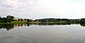
Erlauzwieseler See (the Saußbach flows around the Erlauzwieseler See without feeding it)

The Saußbach flows through the Saußbachklamm near Waldkirchen (the amount of water in the Saußbachklamm depends on the season due to diversions)
Ditch running parallel to the slope (diversion), which is used to generate electricity due to a height difference (slope)


Attractions
- The nearby Erlauzwieseler See with its circular path, the paved wooden footbridge, the granite themed garden and the lake stage invites you to linger and relax and is a popular destination for joggers and walkers.
- The Saußbachklamm is an approx. 20 hectare Bavarian nature reserve .
- The Saußbachklamm nature reserve also offers an easy-to-walk circular path that starts at the Waldkirchen tourist office and is approx. 6 km in length through the deeply cut Saußbachklamm with refreshment stops at the Haller Alm.
Individual evidence
- ↑ Willi Czajka , Udo Bodemüller: Geographical land survey: The natural spatial units on sheet 175 Passau. Federal Institute for Regional Studies, Bad Godesberg 1971. → Online map (PDF; 4.7 MB)
- ↑ a b Height queried (with a right click) on: BayernAtlas of the Bavarian State Government ( information )
- ↑ Length and catchment area according to: Directory of brook and river areas in Bavaria - Danube river area below Inn, page 3 of the Bavarian State Office for the Environment, as of 2016 (PDF; 390 kB)
- ↑ Saußbachleite nature reserve on protectedplanet.net