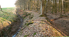
Schaumburger Landwehr

The Schaumburger Landwehr , also known as the Schaumburger Land kink , was a Landwehr established in the late Middle Ages . It ran on the northern edge of the county of Schaumburg and crossed the Schaumburg Forest , where it has been preserved for about 25 kilometers. Because of their extensive preservation, the trenches and ramparts of the Landwehr that still exist are an important archaeological monument in the Schaumburg district .
history
In the late Middle Ages, from the late 13th century onwards, the Grafschaft Schaumburg created a linear fortification and protection strip with land forces, including the Bückethaler Landwehr , which fenced in and enclosed their territory . The facilities were a systematic border security and thus a legal border. The Schaumburger Landwehr formed the border to the Guelph areas in the north with the Calenberg office of Rehburg as part of the Duchy of Braunschweig-Lüneburg . Furthermore, she secured against the possessions of the Loccum monastery . In the north-west, the Landwehr formed the border with the Duchy of Minden , where it can still be seen today over several kilometers as the border between North Rhine-Westphalia and Lower Saxony .
In the Schaumburg Chronicle published in 1614, the historian Cyriacus Spangenberg described the Schaumburger Landwehr as follows:
“A few years ago it was mostly the graffity that the county was surrounded and fortified with huge and solid land defenses, that is, in times of need, in feathers, wars and enemy passages, such land defenses with their slings and knocks are adequately kept, blocked and were locked, and not even easily could have made an incursion or passage without great danger to someone. "
The Schaumburger Landwehr was first mentioned in written sources in 1410. The mention concerned the section between Wiedensahl and Niedernwöhren , which was called "lantwere to wyndesolen".
Decline
At the end of the 16th century, when the Landwehr of the County of Schaumburg, with their trenches, ramparts and curtains, were in a state of disrepair, Count Ernst von Schaumburg had them renewed in 1616. The fortification and protection strip was last renewed in 1665. From the 18th century it began to deteriorate permanently. The separation in the second half of the 19th century led to the extensive removal of land defense systems . The walls and trenches were leveled and the curtains with their bushes and trees cleared and used as fields. In forest areas such as the Schaumburg Forest, on the other hand, the conservation conditions were more favorable for the land forces. In the 20th century they were disrupted in many ways by transport projects and agricultural and forestry activities.
Structure and course

As far as possible, the Schaumburger Landwehr used the natural protection of streams and lowlands. It consisted of two walls, each up to two meters high and seven meters wide. A ditch was in front of the outside. The space between the ramparts was covered with hornbeam , thorn bushes, and hedges. This vegetation zone extended as a strip of terrain to a width of 50 to 200 meters. Part of this vegetation is still present today and makes it difficult to pass.
The Landwehr of the county of Schaumburg have not yet been extensively researched, so their course is not fully known. The remains of the Landwehr in the western area of the Schaumburg Forest begin at the level of the Mittelland Canal . From there it led east to Baum Castle on the border with the Minden diocese . At the castle there was a passage station with a barrier , which is said to have given the castle its name. In the further course to the east, the Landwehr led to the Landwehr forester's house south of Wiedensahl , where there was also a passage. Even today you can see from the vegetation how the Landwehr created a gate-lane-like situation for the arriving ones. The section between Wiedensahl and Niedernwöhren was called the Wiedensahler Landwehr and is mentioned in written sources in 1410 as “lantwere to wyndesolen” . The easternmost remains of the Landwehr can be found at the Winzlarer Grenzgraben, which leads to the Hagenburger Moor and the Steinhuder Meer .
The southern course of the Schaumburger Landwehr in the direction of Rinteln has not yet been explored in more detail. In the 15th century, citizens of Rinteln are said to have provided guard duty at the Landwehr near Möllenbeck . There was a watchtower south of Rinteln, which secured a passage for the Landwehr at a trench crossing. It was called the Rottorf Tower or the Stumpfer Turm .
literature
- Hans-Wilhelm Heine : Schaumburger Land - Burgenland , in the series: Guide to the prehistory and early history of Lower Saxony . (29), Oldenburg 2010, published by the Lower Saxony State Office for Monument Preservation and the Archaeological Commission for Lower Saxony , ISBN 978-3-89995-673-3 .
- Hans-Wilhelm Heine: The medieval castles of the old county of Schaumburg , excursus on land military services in: Schaumburg in the Middle Ages , editor Stefan Brüdermann, publishing house for regional history, Bielefeld, 2013, ISBN 978-3-89534-870-9
Web links
- Description of the Schaumburger Landwehr ( Memento from March 11, 2014 in the Internet Archive ) (PDF, 600 kB)
- Mention of the Schaumburg Landwehr as an important ground monument in the regional spatial planning program of the Schaumburg district from 2003
