
Schaumburg Forest

The Schaumburger forest is one to about 75 m above sea level. NN high forest area with around 40 km² area in the district of Schaumburg in Lower Saxony and in the district of Minden-Lübbecke , in North Rhine-Westphalia ( Germany ).
Geographical location
The Schaumburg Forest is located directly east of the state border with North Rhine-Westphalia in the northwest part of the Schaumburg district not far east of the Weser , south of the Rehburg mountains and northwest of the Mittelland Canal . It extends between Wölpinghausen in the north, Pollhagen and Meerbeck in the east, (to the east of it lie the district town of Stadthagen and the town of Obernkirchen ); Bückeburg in the south, the central town of Minden in the southwest, as well as the city of Petershagen and the area of Wiedensahl in the west. In the north it borders with the Rehburg mountains almost on the district of Nienburg .
The Schaumburg Forest, which is a maximum of 19.5 km long in the southwest-northeast direction and up to four kilometers wide in the northwest-southeast direction, lies in the lowlands between about 45 and 75 m above sea level. NN . Its highest point ( ⊙ ) is to the west of the state road "L 371", which connects Wölpinghausen in the north - with Pollhagen in the south. Almost 800 meters to the west-northwest of this is a 74.3 m above sea level. NN high point.
The state border to the Minden-Lübbecke district, and thus to North Rhine-Westphalia, coincides almost exactly with the north-western border of the forest. Nevertheless, some forest tongues extend into the Westphalian area (e.g. south of Petershagen- Borstel). In addition, the numerous forest islands immediately upstream in the area of the city of Petershagen can still be counted as part of the Schaumburg Forest in a broader sense, so that the Minden-Lübbecke district also has a certain proportion of the Schaumburg Forest.
The "Landwehrallee" runs through the eastern areas in the central part of the Schaumburg Forest, roughly parallel to the Mittelland Canal. This is a wide driveway that leads near the edge of the forest from Mittelbrink-Landwehr (to Niedernwöhren ) in the northeast to Rusbend, to Bückeburg in the southeast.
history
The Schaumburg Forest used to be a border forest between the Principality of Schaumburg-Lippe and Prussia ; today, parts of its western edge form sections of the state border with North Rhine-Westphalia. The Schaumburger Landwehr , which used to extend as far as the Steinhuder Meer and marked the border between Schaumburg-Lippe and Westphalia in the Middle Ages, extends over a length of around 25 km in the Schaumburg Forest . The Schaumburg Forest is the western remnant of the historic Dülwald , which once stretched from Minden to the Steinhuder Meer and was a border forest of old Saxon districts.
In the middle of the forest, on the Petershagen – Bückeburg road, is the Baum hunting lodge and a small mausoleum ; the final resting place of the Schaumburg Count Wilhelm and his family.
Another mausoleum is located in the southern part of the Schaumburg Forest about one kilometer north of the connecting road Meinsen to Cammer (both to Bückeburg). It contains the coffins of the founder of Bad Eilsen , Countess Juliane von Schaumburg-Lippe (1761–1799) and her mother. Juliane had become a widow at an early age, and the grave of her secret lover, the princely chief forester Clemens August von Kaas (1760–1832), is in a very hidden place in the forest, east of Baum Castle.
The Schaumburg Forest acquired cultural and historical significance because Wilhelm Busch often painted and drew on its forest edges and on its forest meadows, because his birthplace Wiedensahl , where he often stayed later, is close to the western edge of the Schaumburg Forest.
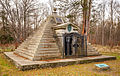
Mausoleum of Count Wilhelm zu Schaumburg-Lippe

Mausoleum of Countess Juliane zu Schaumburg-Lippe


Flora and fauna
The Schaumburg Forest is a commercial forest, about half of which belongs to Alexander Fürst zu Schaumburg-Lippe in Bückeburg . The other half of the forest, the entire part of the forest north of the L 372, from Wiedensahl to Niedernwöhren, is owned by the state of Lower Saxony. The Schaumburg Forest is a predominantly oaks - and book - mixed forest , while old with remnants hat -Eichen. The mighty oaks have always been the most important economic factor in the Schaumburg Forest.
The forest is popular with cyclists because of its straight, wide and shady forest paths on flat terrain that are often kilometers long. There are two touristic bike routes (thematic information on the route, route plan and description) through the Schaumburg Forest: the " Wilhelm Busch Route" and the "Prince Route ", which covers almost the entire length of the Schaumburg Forest from Spießingshol in the north, to Rusbend in the south. There are tourist stops in Hiddenserborn (on the Mittelland Canal, which borders the forest), in Mittelbrink (in the middle of the forest) and in Wiedensahl, which is close to the forest.
The deer and wild boar populations are particularly noteworthy, as well as fallow deer and roe deer.
literature
- Anna-Franziska von Schweinitz: The Derneburg grave pyramid and its model in the Baumer forest. In: Hildesheimer Jahrbuch für Stadt und Stift Hildesheim, Vol. 70/71, 1998/99, pp. 219–231
- Anna-Franziska von Schweinitz: Architecture for Eternity. The burial garden of Count Wilhelm zu Schaumburg-Lippe. In: Critical Reports, 29.2001 No. 2, pp. 21-29
Web links
Individual evidence
- ↑ Highest elevation of the Schaumburg Forest according to the topographical map ( Memento of the original from September 4, 2012 in the Internet Archive ) Info: The archive link has been inserted automatically and has not yet been checked. Please check the original and archive link according to the instructions and then remove this notice. , on natur-erleben.niedersachsen.de
Coordinates: 52 ° 21 ′ 0 ″ N , 9 ° 5 ′ 0 ″ E