
Schlatthof
|
Schlatthof

Community Waldstetten
Coordinates: 48 ° 46 ′ 33 ″ N , 9 ° 49 ′ 19 ″ E
|
|
|---|---|
| Height : | 402 m above sea level NN |
| Residents : | 11 (Jan 1, 2012) |
| Postal code : | 73550 |
| Area code : | 07171 |
 Location of the Schlatthof in the Waldstetten district (gray) and to the village of Waldstetten (black)
|
|
The Schlatthof is a former part of the municipality of Waldstetten in the Ostalb district , which consists of two farms , the front and the rear Schlatthof. The hamlet has been part of the main town of Waldstetten since 1977 .
geography
The Schlatthof is located in the eastern foreland of the Swabian Alb on the edge of the Remstal on a plateau, the Schlattfeld named after it, in the north of the Waldstetten district. The Schlatthof is accessible via the community road Waldstetten– Schwäbisch Gmünd . The Schlatthof is located on circular hiking trail 5 of the Swabian Alb Association Waldstetten (Waldstetten – Schwäbisch Gmünd– Straßdorf –Waldstetten, marking red bars on a white background) and on the Hölltal and Rechberg hiking trail (Schwäbisch Gmünd - Straßdorf - Marienkapelle - Römerbad Schirenhof - Hölltal - Metlangen - Rechberg - Hohenrechberg ruins - Hohenrechberg pilgrimage church - Waldstetten - Schwäbisch Gmünd, blue cross on a white background) of the Swabian Alb Association.
The Schlattfeld drops steeply to the west towards the valley of the Waldstetter Bach , which drains into the Rems . In the south, the terrain also drops steeply into the valley of the Waldstetter Bach at a break-off edge . To the north, the Schlattfeld drops steeply into the Remstal and the town of Schwäbisch Gmünd . In the east and northeast there is a clear break in the terrain into the valley of the Schapfenbach, which flows around the Schlattfeld from east to northeast and then drains into the Rems. In the southeast the Schlattfeld merges almost seamlessly into the first foothills of the Alb mountains.
The approximately 1.56 km² large Schlattfeld slopes slightly to the southeast, the highest point of the inclined plane is at 415 m above sea level. NN approx. 800 m north of the farm, the lowest point at 391 m above sea level. NN approx. 600 m south of the farm.
geology
The soil-forming rock is the Dogger (Brown Jura), more precisely the typical frond sandstone formation of the eastern foothills of the Alb.
history
The name of the farm goes back to the terrain formation "lying on a slope" and is derived from the Old High German word "slad" for "slope, depression in the ground".
The Schlatthof was first mentioned in a document on March 12, 1358 in a deed of ownership. At that time the farm belonged to the patrician Walther von Rinderbach . In 1390 his son Konrad von Rinderbach was registered as the owner. The regesta of the State Archives Ludwigsburg also see the Schlatthof in a "hof zu Slot" named in a document dated January 21, 1410. If this is the case, Wilhelm von Rechberg-Gröningen and his wife Katharina von Heimberg sold Gülten des Hofes, who had to deliver a "Walle von Gegingen", to his uncle Schenk Friedrich zu Limpurg that year . On April 30, 1414, the Adelberg Monastery exchanged Gülten from the Schlatthof for the Lorch Monastery . It could have been the same property "Slathof" that was given to the Adelberg Monastery in exchange on June 12, 1383 by the citizens of Gmünd, Hans Hug and Ludwig Gul, as guardians of Georg ("Georien") Gul. According to this document, the courtyard was built by a "Köllin". Count Kaspar Bernhard II from Rechberg pledged the Schlatthof in 1636 to the then largest landowner in Schwäbisch Gmünd, the Gmünd Hospital , which belonged to the Hospital Order of the Holy Spirit . The farm remained Fallgut until 1818 , before it was triggered by Michael Knödler and then passed on to his descendants.
In the days of falling property, the farm was not always passed on continuously within one family, sometimes several families lived on the farm at the same time, and they were probably not related to each other. If the feudal farmer died, the feud reverted to the liege lord and was re-awarded.
Guaranteed feudal farmers on the Schlatthof were:
- Andreas Frey (1537–1559)
- his son Lorenz Frey (from 1559)
- Lorenz Aubele (1538)
- Lorenz Aubele (possibly his son) (1571)
- the widow of Lorenz Aubele Anna Rötin (until 1599)
- Utz (Ulrich) Rieck (1599–1636)
- Georg Krieg (1623)
- Johannes Georg Betz (1623)
- Ulrich Betz (1636–1655)
- his widow Katharina Betz (from 1655)
- their son Michael Betz (until 1698)
- his widow Barbara Weber (until 1700)
- their son Johannes Betz (until 1715)
- his widow Eva Betz born Maier, later with her second husband Hie (ü) über von Waldau (until 1734)
- their daughter Juliane Betz and her husband Anton Baur from Mutlangen (until 1781)
- their son Jakob Baur with his wife Katharina Kaiser, b. Scheuerle, after her second marriage to Katharina Baur (until 1783)
- the widow Katharina Baur and her third husband Josef Knödler
- their son Michael Knödler (from 1818)
Michael Knödler can release the farm and thus becomes the first free farmer on the Schlatthof. In addition to the actual yard, the Schlatthof includes 12 days' work (approx. 40 a ) meadows, 6 days' work (approx. 20 a ) fields and 8 days' work (approx. 30 a ) forest. Michael Knödler's son Gustav August Knödler (1838–1914) separates from his parents' (rear) Schlatthof and builds a new farm southeast of it, the front Schlatthof.
The area around the Schlatthof is an important place of discovery of Stone Age artifacts for prehistoric research . “Waldstetten-Schlatt”, the name of the place where it was found in experts, is the only open field site in southwest Germany where a Gönnersdorf type woman was found.
Current situation

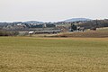
The Schlatthof photographed from the war level
The Vordere Schlatthof

The rear Schlatthof

Company logo of the front Schlatthof

The Schlatthof from the southwest


Front Schlatthof
Josef Knödler, the son of Gustav August Knödler, took over the front Schlatthof in 1908. He became overindebted and had to sell the farm in 1928 to Johann Georg Weber from Dangelhof in Reichenbach , who bought it for his son Eugen. Since then, the front Schlatthof has been owned by the family.
Rear Schlatthof
The Knödler family sold the rear Schlatthof to the Küchle family in 1880 and moved from the farm. The only daughter Franziska Küchle marries Johannes Klingler from Schnittlingen . The rear Schlatthof has been family-owned since then.
In 1977 the Schlatthof, which was previously a separate district , is assigned to the community of Waldstetten. The front Schlatthof today consists of two residential buildings, the Schlatthof 5 built by the Knödler family and the Schlatthof 1 built by the Weber family . There are also stables and farm buildings. The rear Schlatthof also consists of two residential buildings, Schlatthof 3 and Schlatthof 7 and the associated farm buildings.
literature
- Friedgund Betz war: Waldstetter farms - Gschicht 'ond G'schichta von Haus, Hof ond de Leut' . Waldstetten community [ed.], Waldstetten 2008.
Individual evidence
- ↑ Schwäbischer Albverein: Hiking map 1: 50000 Schwäbisch Gmünd and the surrounding area .
- ^ A b Pastor Weser: Locations in, around and to Gmünd , Schwäbisch Gmünd 1937, manuscript in the Schwäbisch Gmünd city archive .
- ^ State archive Ludwigsburg B 113 IU 478 ( digitized version in the state archive Baden-Württemberg ).
- ↑ Wolfgang Runschke: The manorial rule of the Lorch monastery. Studies on the economic history of a Swabian Benedictine abbey from the High Middle Ages to the Reformation , dissertation, University of Tübingen, 2010, p. 388 online . [Note: Runschke does not provide the individual records in footnote 1736, but in footnote 1737: Main State Archives Stuttgart, inventory 102.45 (Lorch monastery stock books), vol. 1].
- ↑ Main State Archives Stuttgart A 469 IU 233 ( digitized in the State Archives Baden-Württemberg ).
- ↑ Friedgund Betz War: Waldstetter Farms Gaiser Print Media, Schwabisch Gmund of 2008.
- ↑ Adolf Regen, Wolfgang Naak, Stefan Wettengl, Simon Fröhle, Harald Floss: A female figure of the Gönnersdorf type from the Magdalenian open-air discovery site in Waldstetten-Schlatt, Ostalbkreis, Baden-Württemberg . In: Harald Floss (Ed.): The Magdalénien in southwest Germany, in Alsace and in Switzerland, Kerns Verlag, Tübingen 2019, ISBN 978-3-935751-29-2 , pp. 267-276; Stefan Wettengl: The Magdalenian around Heubach - The Kleine Scheuer, the Sand and the Schlattäcker near Waldstetten. In: Harald Floss (Ed.): The Magdalénien in southwest Germany, in Alsace and in Switzerland, Tübingen 2019, pp. 33–56.