
Schlottenhof
|
Schlottenhof
City of Arzberg
|
|
|---|---|
 |
|
| Height : | 466–501 m above sea level NN |
| Residents : | 816 (1987) |
| Incorporation : | January 1, 1978 |
| Postal code : | 95659 |
| Area code : | 09233 |
Schlottenhof is a district of the city of Arzberg in the district of Wunsiedel in the Fichtelgebirge , Upper Franconia .
Geography and history
Schlottenhof is located northeast of the core town of Arzberg. The district borders directly on the core city.
From the end of the 19th century to 1964, the Schlottenhof porcelain factory with up to 200 employees produced table and decorative porcelains in Schlottenhof .
As part of the regional reform in Bavaria , Schlottenhof was incorporated into Arzberg on January 1, 1978.
Schlottenhof was also affected by the flood in spring 2018.
coat of arms
Blazon : "In silver a bearded farmer in the costume of the Sechsämterland with a high black pointed hat, black trousers, black suspenders, black slippers, red doublet, silver shirt and silver stockings, holding a black pitchfork in his left hand."
Population development
- 1910: 746
- 1933: 701
- 1939: 677
- 1961: 759
- 1970: 825
- 1987: 816
Culture and sights
Schlottenhof manor
In the village there is a former manor and castle of the von Benckendorff family. The feudal estate at that time was built from 1750 to 1753 using an older part from 1600. The angled passage in the southern part of the wing is artistically interesting for local reasons. The portal has paneled pilasters with profiled fighters and a likewise paneled classical archway with an accentuated keystone. In the courtyard there is a stone fountain basin in a simple rococo shape . The Schlottenhofer Brunnenwastl in traditional Egerland costume is depicted on the eight-sided fountain column .

The manor in Schlottenhof

Sandstone slab from 1726 above the portal of the New Palace with the marriage coat of arms of Benckendorff and Niclot
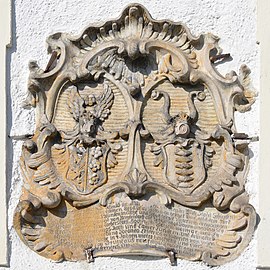
Marriage coats of arms from Benckendorff and von Wiesenthau

Fountain basin


traffic
The district road WUN 18 leads to Oschwitz or Arzberg to the state road St 2176 .
literature
- Friedrich Wilhelm Singer: The Brunnen-Wastl tells. From the life of the community of Schlottenhof . Schlottenhof 1973 (322 pages).
Web links
Individual evidence
- ↑ a b c Federal Statistical Office (ed.): Historical municipality directory for the Federal Republic of Germany. Name, border and key number changes in municipalities, counties and administrative districts from May 27, 1970 to December 31, 1982 . W. Kohlhammer GmbH, Stuttgart and Mainz 1983, ISBN 3-17-003263-1 , p. 701 .
- ↑ http://www.ulischubert.de/geografie/gem1900/gem1900.htm?oberfranken/wunsiedel.htm
- ^ Michael Rademacher: German administrative history from the unification of the empire in 1871 to the reunification in 1990. District of Wunsiedel. (Online material for the dissertation, Osnabrück 2006).
- ↑ http://gov.genealogy.net/item/show/SCHHOFJO60CB
.svg)
Arzberg | Bergnersreuth | Floor house | Dötschenmühle | Elisenfels | Trout Mill | Garmersreuth | Hagenhaus | Haid | Heiligenfurt | Pebble mill | Klausen | Krippnermühle | Märzenhaus | Oschwitz | Preisdorf | Rosenbühl | Röthenbach | Sand mill | Shaft | Schlottenhof | Sussia | Steinau | Pond mill | Theresienfeld