Schwarzbach (Saalach)
| Schwarzbach | ||
|
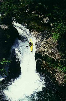
Kayaking in a kayak (November 2006) |
||
| Data | ||
| Water code | DE : 1864912 | |
| location | District of Berchtesgadener Land | |
| River system | Danube | |
| Drain over | Saalach → Salzach → Inn → Danube → Black Sea | |
| source | a cave (Schwarzbachloch) of the Reiter Alm 47 ° 38 ′ 20 ″ N , 12 ° 50 ′ 49 ″ E |
|
| Source height | 770 m above sea level NN | |
| Spring discharge |
MNQ MHQ |
30 l / s 17 m³ / s |
| muzzle | near Unterjettenberg (Gem. Schneizlreuth ) in the Saalach coordinates: 47 ° 40 ′ 47 " N , 12 ° 49 ′ 48" E 47 ° 40 ′ 47 " N , 12 ° 49 ′ 48" E |
|
| Mouth height | 500 m above sea level NN | |
| Height difference | 270 m | |
| Bottom slope | 45 ‰ | |
| length | 6 km | |
The Schwarzbach is an approximately 6 km long right tributary of the Saalach in the Berchtesgadener Land in Bavaria .
Schwarzbachloch
The Schwarzbach rises from an active water cave, the Schwarzbachloch (cadastral number 1337/1). It is located on the eastern flank of the Reiter Alm near the Schwarzbachwacht near Ramsau near Berchtesgaden . The 3120 meter long water cave was created by the groundwater accumulation between Ramsaudolomit and Dachstein limestone . The karst spring rises directly from the cave or a little below (min. 30 l / s, max 17,000 l / s), depending on the bed . The water temperature is 5.4 ° Celsius. When the water level is low, it is possible to penetrate up to 40 meters into the tunnel system. However, this is prohibited by a nature reserve ordinance issued by the government of Upper Bavaria. The Schwarzbachloch was already marked on the Bavarian map published in 1554 by Philipp Apian . In 1968 Jochen Hasenmayer dived through the cave.
course
The gorge-like mountain stream runs north with many waterfalls and flows into the Saalach on the right at Unterjettenberg (Gem. Schneizlreuth ) . For reasons of nature conservation, there has been a year-round traffic ban since 1996.
Tributaries
- Reitkendlgraben (left)
- Big Kälblgraben (left)
- Eisbach (left)
Schwarzbachalm
On the upper reaches of the Schwarzbach, northwest below the Schwarzbachwacht , is the Schwarzbachalm, which is divided as Schwarzbachalmen into Obere and Untere Schwarzbachalm .
Web links
Individual evidence
- ↑ Salzburger Höhlenbuch, Volume 1, p. 40.

