Sehlde (Elze)
|
Sehlde
City of Elze
|
||
|---|---|---|
| Coordinates: 52 ° 5 ′ 50 " N , 9 ° 41 ′ 47" E | ||
| Height : | 92 m above sea level NHN | |
| Area : | 4.95 km² | |
| Residents : | 456 (Jun. 30, 2018) | |
| Population density : | 92 inhabitants / km² | |
| Incorporation : | March 1, 1974 | |
| Postal code : | 31008 | |
| Area code : | 05068 | |
|
Location of Sehlde in Lower Saxony |
||
|
Church building
|
||
Sehlde is a south-western district of the city of Elze in the Lower Saxony district of Hildesheim .
geography
Sehlde is a little off the beaten track between the B 1 and B 3 federal highways .
history
First mention, incorporations
Sehlde was first mentioned in a document around 1300 in documents from the Bock von Nordholz, in which their possessions were recorded in Sehlde.
As a result of the regional reform in Lower Saxony , Sehlde became one of seven districts of the city of Elze on March 1, 1974.
Population development
| year | Residents | source |
|---|---|---|
| 1910 | 391 | |
| 1925 | 890 | |
| 1933 | 349 | |
| 1939 | 319 | |
| 1950 | 748 | |
| 1956 | 610 | |
| 1973 | 544 | |
| 2018 | 456 |

|
politics
City Councilor and Mayor
Sehlde is represented at the municipal level by the Elze City Council.
Mayor
The mayor of Sehlde is Leon Grünhagen (SPD). His deputy is Dirk Garve.
coat of arms
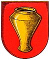
The municipality was awarded the municipal coat of arms on September 28, 1938 by the President of the Province of Hanover . The district administrator from Alfeld presented it on March 3, 1939.
| Blazon : "In red a golden Cherusker vessel (so-called situla ) from the 1st century after the turn of the century." | |
| Justification of the coat of arms: The coat of arms of the Sehlde community coat of arms is based on the coat of arms of the "von Grapendorf" family, who once lived in Sehlde and shows a medieval pot; only now the community chose this beautiful Cheruscan vessel, which was found during the construction of the water pipeline in the village, as its coat of arms symbol. |
Culture and sights
The Liebfrauenkirche stands in the center of the place. The church was built around 1300 and substantially rebuilt in 1770. There is a listed cemetery to the north and south of the church.
Web links
- Website from the Sehlde district
- Sehlde on the website of the city of Elze
- Internet portal Elzer Spiegel - Sehlde district
Individual evidence
- ↑ a b c Numbers and dates. In: Website City of Elze. June 30, 2018, accessed April 10, 2019 .
- ^ Federal Statistical Office (ed.): Historical municipality directory for the Federal Republic of Germany. Name, border and key number changes in municipalities, counties and administrative districts from May 27, 1970 to December 31, 1982 . W. Kohlhammer, Stuttgart / Mainz 1983, ISBN 3-17-003263-1 , p. 205 .
- ^ Ulrich Schubert: Community directory Germany 1900 - Landkreis Gronau. Information from December 1, 1910. In: gemeindeververzeichnis.de. January 5, 2020, accessed February 14, 2020 .
- ^ A b c Michael Rademacher: German administrative history from the unification of the empire in 1871 to the reunification in 1990. Alfeld district ( see under: No. 64 ). (Online material for the dissertation, Osnabrück 2006).
- ↑ a b Statistisches Bundesamt Wiesbaden (ed.): Official municipality register for the Federal Republic of Germany - 1957 edition (population and territorial status September 25, 1956, for Saarland December 31, 1956) . W. Kohlhammer, Stuttgart 1958, p. 164 ( digitized version ).
- ↑ Lower Saxony State Administration Office (ed.): Municipal directory for Lower Saxony . Municipalities and municipality-free areas. Self-published, Hanover January 1, 1973, p. 28 , district of Alfeld (Leine) ( digitized [PDF; 21.3 MB ; accessed on February 14, 2020]).
- ↑ Head of the districts - Sehlde. In: Website of the city of Elze. Retrieved March 25, 2019 .
- ^ A b Wilhelm Barner : Coat of arms and seal of the Alfeld district . Rebinding. Lax GmbH & Co. KG, Hildesheim 1998 ( digitized version of the text part of the first edition from 1940 [PDF; 10.0 MB ; accessed on June 11, 2019]).


