
Sekong Province
| ເຊ ກອງ Sekong
|
|
|---|---|
  |
|
| Basic data | |
| Country | Laos |
| Capital | Sekong |
| surface | 7665 km² |
| Residents | 113,048 (2015) |
| density | 15 inhabitants per km² |
| ISO 3166-2 | LA-XE |
.jpg) |
|
Coordinates: 15 ° 42 ' N , 106 ° 42' E
Sekong (also Xekong , Lao : ເຊ ກອງ - [ Sēkɔ̄ṅ ]) is a province of Laos .
geography
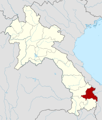
Sekong is located in the southeast of the country. The neighboring provinces are (clockwise from the south): Attapeu , Champasak and Salavan . To the east, Sekong borders the Quảng Nam Province of Vietnam .
Sekong is the second smallest province with 7,665 km², it has the smallest number of inhabitants (around 85,000 in the 2005 census, estimated for 2009 95,000) and also the lowest population density of all provinces (11.1 inhabitants / km²). This is due to the remoteness and rocky landscape.
population
The population consists mainly of Lao Theung , who are represented here by several ethnic groups. Malaria is very common in the province and the child mortality rate is the highest in the country.
history
Sekong was created in 1984 when the area was separated from Salavan Province .
Administrative division
The province consists of the following four districts ( ເມືອງ - [ mʉ̄aṅ ]):
| code | District | Lao |

|
|---|---|---|---|
| 15-01 | Lamam (lamarm) | ລະ ມາມ [ lamām ] | |
| 15-02 | Kaleum | ກະ ເລິມ [ Kalœm ] | |
| 15-03 | Dakcheung | ດັກ ເຈິງ [ Dâkčœṅ ] | |
| 15-04 | Thateng | ທ່າ ແຕງ [ Tʰā̀tǣṅ ] |
Individual evidence
- ↑ Lao Department of Statistics: Mid-Year Population: Area and average mid-year population by provinces in 1976 - 2005 ( Memento of the original from May 17, 2012 in the Internet Archive ) Info: The archive link was inserted automatically and has not yet been checked. Please check the original and archive link according to the instructions and then remove this notice.
- ↑ Martin Stuart-Fox : Historical Dictionary of Laos. 3rd edition, Scarecrow Press, 2008, p. 386.
Web links
Provinces: Attapeu | Bokeo | Bolikhamsai | Champasak | Houaphan | Khammuan | Luang Namtha | Luang Prabang | Oudomxay | Phongsali | Sainyabuli | Salavan | Savannakhet | Saysomboun | Sekong | Vientiane | Xieng Khouang
Prefecture: Vientiane