Semerville
| Semerville | ||
|---|---|---|

|
|
|
| local community | Beauce la Romaine | |
| region | Center-Val de Loire | |
| Department | Loir-et-Cher | |
| Arrondissement | Blois | |
| Coordinates | 47 ° 56 ' N , 1 ° 23' E | |
| Post Code | 41160 | |
| Former INSEE code | 41244 | |
| Incorporation | January 1, 2016 | |
| status | Commune déléguée | |
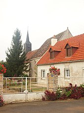
 former Semerville Town Hall |
||
Semerville is a village and a former French commune of 100 people (as of January 1, 2017) in the department of Loir-et-Cher in the region Center-Val de Loire . It belonged to the arrondissement of Blois and the canton of La Beauce (until 2015: canton of Ouzouer-le-Marché ).
With effect from January 1, 2016, Semerville merged with the former municipalities of La Colombe , Membrolles , Ouzouer-le-Marché , Prénouvellon , Tripleville and Verdes to form the Commune nouvelle Beauce la Romaine and has the status of a Commune déléguée in the new municipality .
location
Semerville is about 44 kilometers west-northwest of Orléans .
Demographic development
| 1962 | 1968 | 1975 | 1982 | 1990 | 1999 | 2006 | 2013 | |
| 143 | 116 | 111 | 101 | 101 | 79 | 98 | 97 | |
| Source: Cassini and INSEE | ||||||||
Attractions
- Remains of the Roman road, monument historique since 1978
- Sainte-Madeleine church from the 12th century
Web links
Commons : Semerville - collection of images, videos and audio files

