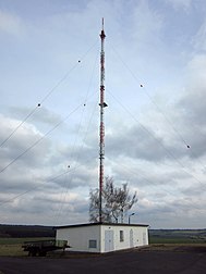
Keula transmitter
|
Keula transmitter
Radio transmission point Menteroda 2
|
||
|---|---|---|
| Basic data | ||
| Place: | Keula ( Helbedündorf ) | |
| Country: | Thuringia | |
| Country: | Germany | |
| Altitude : | 429 m above sea level NHN | |
| Coordinates: 51 ° 20 ′ 7.7 ″ N , 10 ° 32 ′ 2.8 ″ E | ||
| Use: | Broadcasting station | |
| Owner : | German radio tower | |
| Mast data | ||
| Construction time : | 1993 | |
| Operating time: | Since 1993 | |
| Total height : | 180 m | |
| Data on the transmission system | ||
| Waveband : | FM transmitter | |
| Radio : | VHF broadcasting | |
| Position map | ||
|
|
||
The Keula transmitter is a facility of Deutsche Telekom AG northeast of Keula in the Kyffhäuserkreis in Thuringia for the distribution of VHF radio programs.
history
On October 7, 1974, broadcasting operations in Keula began on the site of the current transmitter. The mobile 5 kW medium wave transmitter broadcast the program of Radio DDR 1 on the frequency 557 kHz. It was operated until February 1975 by colleagues from the operating office 6412 of the Leipzig radio office. From March 1975, the colleagues at the Erfurt radio office took over the broadcasting operations. It was blasted with a 50 m steel lattice mast. With the frequency change in 1978 to 1575 kHz, the program was broadcast by Berlin radio. In the mid-1980s the frequency was changed to 1170 kHz. After the fall of the Wall, the transmitter was demolished.
In 1993, a new, 180 meter high guyed steel truss mast was erected at the same location .
Frequencies and Programs
Analog radio (VHF)
|
Frequency (MHz) |
program | RDS PS | RDS PI | Regionalization |
ERP (kW) |
Antenna pattern round (ND) / directional (D) |
Polarization horizontal (H) / vertical (V) |
|---|---|---|---|---|---|---|---|
| 98.5 | MDR Thuringia | MDR_THUE | D7F1 | Heiligenstadt | 20th | D (30-180 °) | H |
| 104.5 | Landeswelle Thuringia | COUNTRY | D6F9 (regional), D3F9 |
North | 10 | D (270–220 °) | H |
Until January 2010, a DAB ensemble was broadcast on DAB channel 12B.
| Former DAB multiplex in the disconnected DAB old network Kanal 12B (Thuringia) | ||||||||||
|---|---|---|---|---|---|---|---|---|---|---|
|
Analog television (PAL)
Before the switch to DVB-T, the broadcasting location was still used for analog television.
| channel |
Frequency (MHz) |
program |
ERP (kW) |
Transmission diagram round (ND) / directional (D) |
Polarization horizontal (H) / vertical (V) |
|---|---|---|---|---|---|
| 45 | 663.25 | MDR television Thuringia | 50 | D. | H |


