Seto-Ōhashi
Seto-Ōhashi ( Japanese 瀬 戸 大橋 'Great Seto Bridge') is the name of a bridge-viaduct combination over the Seto Inland Sea . It connects Okayama Prefecture on the Japanese main island of Honshu with the city of Sakaide ( Kagawa Prefecture ) on Shikoku Island .
When it was completed in 1988, Seto-Ōhashi was the first bridge connection between Honshū and Shikoku. It was followed in 1998 by the Kobe-Awaji-Naruto highway between Kobe and Naruto and in 1999 by the Nishiseto highway between Onomichi ( Hiroshima Prefecture ) and Imabari ( Ehime Prefecture ).
The bridge complex
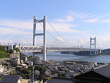
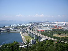
The Seto-Ōhashi is divided into three suspension bridges , two cable-stayed bridges , a normal steel truss bridge and four viaducts / elevated roads over five of the Shiwaku Islands ( 塩 飽 諸島 Shiwaku-shotō ). The total length is 13.1 km, with 9368 m above the water, and the average height of the bridge pylons is 160 m. The construction time was almost ten years.
The bridges are consistently two-story. The 35 meter wide upper deck is 22.5 meters from the Seto-Chūō highway with four lanes (i.e. two in each direction) plus median and hard shoulders. The double-track JR Seto-Ōhashi line ( Cape gauge ) runs on the 30-meter-wide lower deck , leaving space for a second pair of tracks. The height of the two-storey bridge is 13 meters.
Use of the bridge complex is subject to a toll and costs 3500 yen per trip , which corresponds to around 28 euros at 1 € = 125 ¥ (as of August 28, 2020) .
Compared to the ferry, which takes about an hour to cross from Uno ( Tamano ) to Takamatsu , the Seto-Ōhashi, with a journey time of about 15 minutes, connects Shikoku much better to the metropolitan areas of Japan on Honshū, especially since it is less connected in bad weather fails as the shipping traffic. The bridge complex is earthquake-proof and withstands typhoons .
history
A railway bridge over the Seto Inland Sea at this point was proposed by Ōkubo Jinnojō ( 大 久保 諶 之 丞 ) as early as 1889 . The thought only got a boost in 1955 when the Shiun state railway ferry leaked in the thick fog off Takamatsu in a collision with another state railway ferry and 168 people died, including 100 elementary and middle school students on school trips. After various preparatory conferences and studies, the Honshū Shikoku Bridge Authority was established in 1970. After the oil crisis was overcome in 1973, an environmental impact analysis was published in 1978 and construction began. It lasted just under ten years and cost about 1.1338 trillion yen . 705,000 tons of steel and 3,646,000 cubic meters of concrete were used. Around 2000 companies were involved. Although nets and lifeline ropes were used to the highest safety standards, the construction cost 13 workers their lives. On April 10, 1988, the route was opened to traffic.
The individual sections from north to south
- Shimotsui Seto Bridge
- The Shimotsui-Seto Bridge ( 下 津 井 瀬 戸 大橋 Shimotsui-Seto-ōhashi ) is a suspension bridge with a span of 940 meters and a total length of 1,447 meters, which made it one of the 13 most spanned bridges in the world when it was inaugurated in 1988 . It connects the 205 m (road) or 230 m (rail) long Washūzan tunnel ( 鷲 羽山 ト ン ネ ル Washūzan-tonneru ) on the Japanese main island of Honshū with the island of Hitsuishi-jima ( 櫃 石島 ), to which a descent leads. The clearance height for the passage of ships is 31 meters.
- Hitsuishijima Viaduct
- The Hitsuishijima Viaduct ( 櫃 石島 高架橋 Hitsuishijima-kōkakyō ) leads 1316 meters further to the other end of the island of Hitsuishi-jima and merges there into the Hitsuishijima Bridge.
- Hitsuishijima Bridge
- The Hitsuishijima Bridge ( 櫃 石島 橋 Hitsuishijima-hashi ) is a cable-stayed bridge with two pylons standing in the water . The span is a good 420 meters with a total length of 792 meters. The bridge leads to the island of Iwakuro-jima ( 岩 黒 島 ), where there is another exit.
- Iwakurojima Viaduct
- The adjoining Iwakurojima Viaduct ( 岩 黒 島 高架橋 Iwakurojima-kōkakyō ) merges into the Iwakurojima Bridge after 93 meters.
- Iwakurojima Bridge
- The Iwakurojima Bridge ( 岩 黒 島 橋 Iwakurojima-hashi ) is an image of the Hitsuishijima Bridge in terms of its dimensions and appearance. It ends on the 4246 square meter island Wasa-shima ( 羽 佐 島 ).
- Yoshima Bridge
- From there, the Yoshima Bridge ( 与 島 橋 Yoshima-hashi ) made of steel framework leads to the largest of the islands crossed by Seto-Ōhashi, Yoshima ( 与 島 ), with 1.1 square kilometers , where there is another exit. The Yoshima Bridge is 877 meters long with a span of 245 meters.
- Yoshima Viaduct
- Yoshima Viaduct ( 与 島 高架橋 Yoshima-kōkakyō ) is the name of the 717 meter long route that leads across Yoshima.
- Kita-Bisan-Seto-Bridge
- With the Kita-Bisan-Seto-Bridge ( 北 備 讃 瀬 戸 大橋 Kita-Bisan-Seto-ōhashi ) another suspension bridge follows. Their span of 990 meters with a total length of 1611 meters was only exceeded by ten bridges in the world when they opened in 1985 . The clear height for the passage of ships is at least 65 meters above the mean tide level. Due to the arching of the bridge body, a height of up to 93 meters above sea level is reached on the roadway of the upper deck. The bridge ends on the 646 square meter islet Mitsugo-shima ( 三 つ 子 島 ), which is hardly wider than the bridge.
- Minami-Bisan-Seto Bridge
- This is where the Minami-Bisan-Seto Bridge ( 南 備 讃 瀬 戸-Minami -Bisan-Seto-ōhashi ) connects , the two pylons of which are anchored in the seabed. It is an image of the Kita-Bisan-Seto-Bridge, but much longer with the same carriageway height. Its span of 1,100 meters with a total length of 1,723 meters made it the number 5 suspension bridge in the world when it opened. A bridge for combined road and rail traffic with a larger span was only opened in 1997 with the Tsing Ma Bridge .
- Bannosu Viaduct
- Shikoku is followed by the Bannosu Viaduct ( 番 の 州 高架橋 Bannosu-kōkakyō ) with a length of 2939 meters.
Web links
- Honshu Shikoku Bridges (PDF; 17.2 MB)
- Honshu-Shikoku Bridge Expressway Company Limited - Route Description
- Honshu-Shikoku Bridge Expressway Company Limited - Company History
Individual evidence
- ↑ a b c d e f g h i j k l m 瀬 戸 大橋 (本州 四 国 連絡 橋) . Sakaide City, January 1, 2012, accessed May 18, 2013 (Japanese).
- ↑ Honshu-Shikoku Bridges. (PDF) Honshu-Shikoku Bridge Expressway Company, March 2011, p. 11 , accessed on May 13, 2011 .
- ↑ 橘 正 範 : 大 久保 諶 之 丞 . Retrieved May 13, 2011 (Japanese, biography of Ōkubo Jinnojō with full text of the speech of May 23, 1889 for the opening of the Sanuki Railway between Marugame and Kotohira ).
- ↑ Un'yu anzen iinkai ( 運輸 安全 委員会 , “Traffic Safety Commission”; English Japan Transporation Safety Board ) of the MLIT : “謎 の 左 転” か ら 半 世紀 ( “nazo no saten” kara hanseiki , “Half a century after the “Puzzling left turn” [the Shiun-maru before the collision] “; report on the 50th anniversary of the accident, pdf)
Coordinates: 34 ° 23 '54 " N , 133 ° 48' 36" E


