Sakaide
| Sakaide-shi 坂 出 市 |
||
|---|---|---|
| Geographical location in Japan | ||
|
|
||
| Region : | Shikoku | |
| Prefecture : | Kagawa | |
| Coordinates : | 34 ° 19 ' N , 133 ° 52' E | |
| Basic data | ||
| Surface: | 92.46 km² | |
| Residents : | 51,196 (October 1, 2019) |
|
| Population density : | 554 inhabitants per km² | |
| Community key : | 37203-0 | |
| Symbols | ||
| Flag / coat of arms: | ||
| Tree : | Viburnum odoratissimum var. Awabuki | |
| Flower : | Cherry blossom , jewelry basket | |
| town hall | ||
| Address : |
Sakaide City Hall 2 - 3 - 5 , Muro-machi Sakaide -shi Kagawa 762-8601 |
|
| Website URL: | http://www.city.sakaide.lg.jp/ | |
| Location Sakaides in Kagawa Prefecture | ||
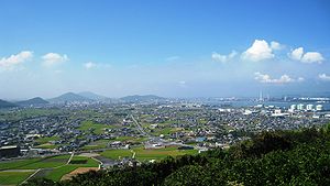
Sakaide ( Japanese 坂 出 市 , - shi ) is a city in the Japanese prefecture of Kagawa .
history
The tomb of Emperor Sutoku (1119–1164) is located on Mount Shiramine, 7 km to the east. The city was founded on July 1, 1942 . Since 1988 the Seto-Ōhashi Bridge has been connecting Okayama with Shikoku via the Sakaide area.
economy
It has been a salt mining center since the early 17th century. A part of the salt fields has meanwhile been converted into industrial land. In addition to salt extraction, the manufacture of chemicals, oil products and machines is also important today.
traffic
- Train:
- Street:
- Takamatsu Highway
- Seto Chūō Highway
- National Road 11 : to Tokushima and Matsuyama
- National Road 30 : to Okayama and Takamatsu
- National Road 438
- medium sized port
Town twinning
Neighboring cities and communities
Personalities
- Yūki Fuke (* 1991), soccer player
Individual evidence
Web links
Commons : Sakaide - Collection of images, videos and audio files
- 財政 状況 資料 集 . Finances. Sakaide, May 9, 2016;accessed August 22, 2016(Japanese).


