Sanuki (Kagawa)
| Sanuki-shi さ ぬ き 市 |
||
|---|---|---|
|
|
||
| Geographical location in Japan | ||
| Region : | Shikoku | |
| Prefecture : | Kagawa | |
| Coordinates : | 34 ° 20 ′ N , 134 ° 10 ′ E | |
| Basic data | ||
| Surface: | 158.88 km² | |
| Residents : | 47,506 (October 1, 2019) |
|
| Population density : | 299 inhabitants per km² | |
| Community key : | 37206-4 | |
| Symbols | ||
| Flag / coat of arms: | ||
| Tree : | jaw | |
| Flower : | Jewelry baskets | |
| Color : | green | |
| town hall | ||
| Address : |
Sanuki City Hall 5385 - 8 , Shido Sanuki -shi Kagawa 769-2195 |
|
| Website URL: | http://www.city.sanuki.kagawa.jp | |
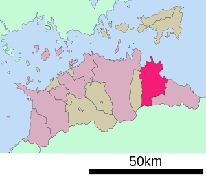
| Location of Sanukis in Kagawa Prefecture | ||
Sanuki ( Japanese さ ぬ き 市 , - shi ) is a city in the Japanese prefecture of Kagawa .
history
The city of Sanuki was formed on April 1, 2002 from the former communities Tsuda ( 津 田 町 , -chō ), Ōkawa ( 大川 町 , -chō ), Shido ( 志 度 町 , -chō ), Sankawa ( 寒 川 町 , -chō ) and Nagao ( 長尾 町 , -chō ) of the district Ōkawa founded. The name of the city is based on the old province name Sanuki (讃 岐).
Attractions
- The last three temples on the Shikoku pilgrimage route :
traffic
- Train:
- Street:
- Takamatsu Highway
- National Road 11 : to Tokushima and Matsuyama
- National Road 377
education
The Kagawa campus of the private Bunri University Tokushima is located in Sanuki .
Neighboring cities and communities
Town twinning
-
 Eisenstadt , since 1993
sons and daughters of the town
- Hiraga Gennai (1728–1780), naturalist and painter, born in Shido
- Toshihiro Horikawa (* 1989), football player
Individual evidence
- ↑ Originally with Shido.
- ^ Austrian-Japanese relations. Japanese Embassy Austria, archived from the original on December 19, 2012 ; accessed on August 22, 2016 .
Web links
Commons : Sanuki - collection of images, videos and audio files


