Mannō (Kagawa)
| Mannō-chō ま ん の う 町 |
||
|---|---|---|
| Geographical location in Japan | ||
|
|
||
| Region : | Shikoku | |
| Prefecture : | Kagawa | |
| Coordinates : | 34 ° 12 ' N , 133 ° 50' E | |
| Basic data | ||
| Surface: | 194.17 km² | |
| Residents : | 17,504 (October 1, 2019) |
|
| Population density : | 90 inhabitants per km² | |
| Community key : | 37406-7 | |
| Symbols | ||
| Flag / coat of arms: | ||
| town hall | ||
| Address : |
Mannō Town Hall 430 Yoshinoshimo Mannō -chō, Nakatado-gun Kagawa 766-0022 |
|
| Website URL: | http://www.town.manno.lg.jp | |
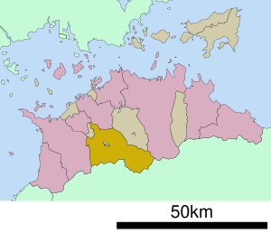
| Location Mannōs in Kagawa Prefecture | ||
Mannō ( Japanese ま ん の う 町 , - chō ) is a city in Nakatado-gun in the Japanese prefecture of Kagawa .
history
Mannō, at that time still in the Kanji spelling ( 満 濃 町 , Mannō-chō ), was created on April 1, 1955 from the merger of the Mura or Son Kanno ( 神 野村 , -son ), Shijō ( 四条 村 , -mura ) and Yoshino ( 吉野 村 , -mura ) in the nakatado-gun. On July 1, 1955, the Mura Takashino ( 高 篠 村 ) was incorporated into the Nakatado-gun and on September 30, 1956 the Mura Nagasumi ( 長 炭 村 , -mura ) was incorporated into the Ayauta-gun . On March 31, 1956 a western and on October 10, 1957 an eastern district was incorporated into Kotohira .
On March 20, 2006 the Chō Mannō, Chūnan ( 仲 南 町 , -chō ) and Kotonami ( 琴 南 町 , -chō ) merged to form the new Mannō, this time in Hiragana spelling.


